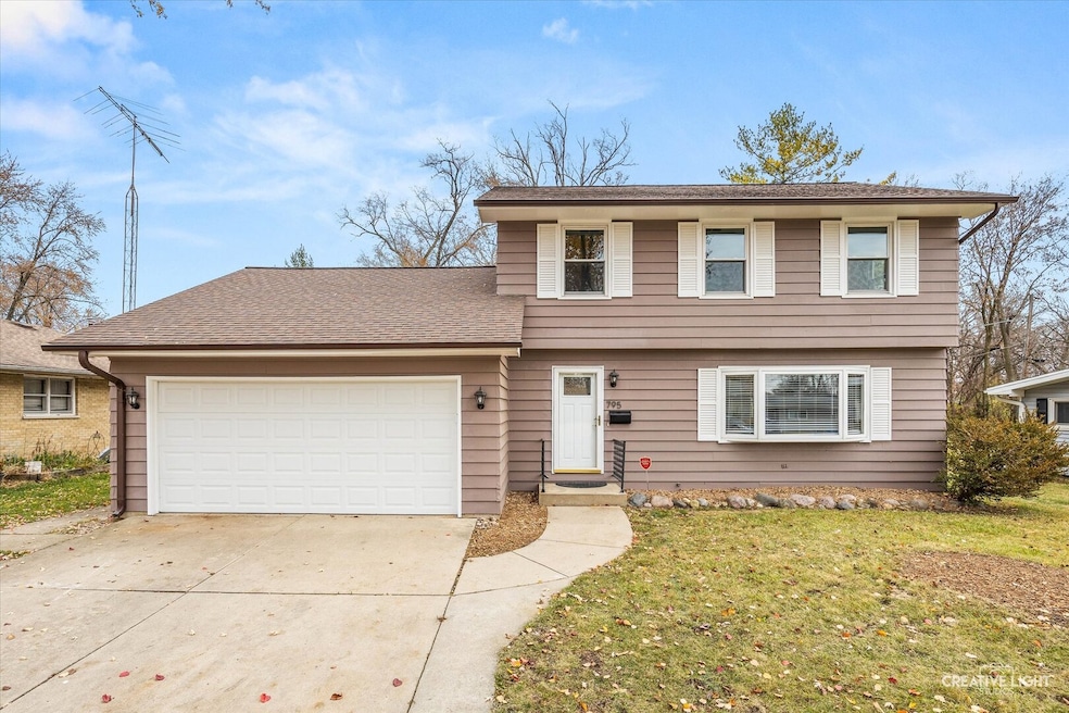
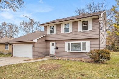
795 N Elmwood Dr Aurora, IL 60506
North River NeighborhoodEstimated payment $2,534/month
Highlights
- Popular Property
- Bay Window
- Living Room
- Formal Dining Room
- Patio
- Laundry Room
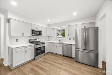
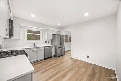
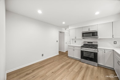
About This Home
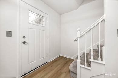
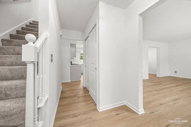
Completely renovated and move-in ready! This beautiful 3-bed, 2.5-bath home has been updated from top to bottom throughout. Enjoy a brand-new kitchen featuring new stainless steel appliances, modern cabinetry, & stylish quartz countertops & backsplash. The interior offers fresh neutral paint, white trim & doors, new carpet, and new vinyl plank flooring for a clean, updated look. The exterior has been freshly painted and includes a newer roof- 2 years old. Other updates include a new water heater and newer HVAC (2013) for added peace of mind. The full unfinished basement is large providing endless possibilities and provides excellent storage. This stunning home is truly turnkey-just move in and enjoy! No HOA, lower taxes, close to i88, schools & shopping.
Home Details
Home Type
- Single Family
Est. Annual Taxes
- $5,881
Year Built
- Built in 1972 | Remodeled in 2025
Lot Details
- Lot Dimensions are 124x69x124x69
Parking
- 2 Car Garage
- Parking Included in Price
Home Design
- Concrete Perimeter Foundation
Interior Spaces
- 1,800 Sq Ft Home
- 2-Story Property
- Bay Window
- Family Room
- Living Room
- Formal Dining Room
- Basement Fills Entire Space Under The House
- Laundry Room
Kitchen
- Range
- Microwave
- Dishwasher
Flooring
- Carpet
- Laminate
Bedrooms and Bathrooms
- 3 Bedrooms
- 3 Potential Bedrooms
Outdoor Features
- Patio
- Shed
Utilities
- Central Air
- Heating System Uses Natural Gas
Listing and Financial Details
- Senior Tax Exemptions
- Homeowner Tax Exemptions
Map
Home Values in the Area
Average Home Value in this Area
Tax History
| Year | Tax Paid | Tax Assessment Tax Assessment Total Assessment is a certain percentage of the fair market value that is determined by local assessors to be the total taxable value of land and additions on the property. | Land | Improvement |
|---|---|---|---|---|
| 2024 | $5,881 | $90,274 | $9,711 | $80,563 |
| 2023 | $5,538 | $80,660 | $8,677 | $71,983 |
| 2022 | $5,541 | $73,595 | $7,917 | $65,678 |
| 2021 | $5,255 | $68,518 | $7,371 | $61,147 |
| 2020 | $5,741 | $72,326 | $6,847 | $65,479 |
| 2019 | $5,549 | $67,746 | $6,344 | $61,402 |
| 2018 | $5,082 | $61,905 | $5,868 | $56,037 |
| 2017 | $5,099 | $60,545 | $5,407 | $55,138 |
| 2016 | $4,476 | $53,131 | $4,635 | $48,496 |
| 2015 | -- | $46,338 | $3,986 | $42,352 |
| 2014 | -- | $42,941 | $3,663 | $39,278 |
| 2013 | -- | $49,604 | $3,714 | $45,890 |
Property History
| Date | Event | Price | List to Sale | Price per Sq Ft |
|---|---|---|---|---|
| 11/26/2025 11/26/25 | For Sale | $389,900 | -- | $217 / Sq Ft |
Purchase History
| Date | Type | Sale Price | Title Company |
|---|---|---|---|
| Interfamily Deed Transfer | -- | None Available | |
| Interfamily Deed Transfer | -- | First American Title Ins Co |
Mortgage History
| Date | Status | Loan Amount | Loan Type |
|---|---|---|---|
| Closed | $97,500 | No Value Available |
Source: Midwest Real Estate Data (MRED)
MLS Number: 12524179
APN: 15-16-302-015
Disclaimer: Certain information contained herein is derived from information provided by parties other than Homes.com. All information provided is deemed reliable, but is not guaranteed to be accurate and should be independently verified.
![]() Based on information submitted to the MLS GRID. All data is obtained from various sources and may not have been verified by broker or MLS GRID. Supplied Open House Information is subject to change without notice. All information should be independently reviewed and verified for accuracy. Properties may or may not be listed by the office/agent presenting the information. Some IDX listings have been excluded from this website.
Based on information submitted to the MLS GRID. All data is obtained from various sources and may not have been verified by broker or MLS GRID. Supplied Open House Information is subject to change without notice. All information should be independently reviewed and verified for accuracy. Properties may or may not be listed by the office/agent presenting the information. Some IDX listings have been excluded from this website.
The Digital Millennium Copyright Act of 1998, 17 U.S.C. § 512 (the “DMCA”) provides recourse for copyright owners who believe that material appearing on the Internet infringes their rights under U.S. copyright law. If you believe in good faith that any content or material made available in connection with our website or services infringes your copyright, you (or your agent) may send us a notice requesting that the content or material be removed, or access to it blocked.
Notices must be sent in writing by email to DMCAnotice@MLSGrid.com.
The DMCA requires that your notice of alleged copyright infringement include the following information:
(1) description of the copyrighted work that is the subject of claimed infringement;
(2) description of the alleged infringing content and information sufficient to permit us to locate the content;
(3) contact information for you, including your address, telephone number and email address;
(4) a statement by you that you have a good faith belief that the content in the manner complained of is not authorized by the copyright owner, or its agent, or by the operation of any law;
(5) a statement by you, signed under penalty of perjury, that the information in the notification is accurate and that you have the authority to enforce the copyrights that are claimed to be infringed; and
(6) a physical or electronic signature of the copyright owner or a person authorized to act on the copyright owner’s behalf. Failure to include all of the above information may result in the delay of the processing of your complaint.
- 781 N Elmwood Dr
- 1104 New Haven Ave
- 616 Morton Ave
- 1351 Monomoy St Unit D
- 1389 Monomoy St Unit B2
- 1296 Yellowpine Dr
- 833 N Randall Rd Unit C4
- 943 Charles St
- 910 Southbridge Dr
- 809 W Park Ave
- 900 Charles St
- 602 N May St
- 930 W New York St Unit 932
- 972 Westgate Dr
- 526 N View St
- 1035 Newcastle Ln
- 519 N View St
- 850 W Galena Blvd
- 931 W Downer Place
- 541 Charles St
- 874 Foran Ln
- 1240 Nantucket Rd
- 1240 W Indian Trail
- 1241 Coffeeberry Ln
- 305 N View St Unit 2
- 305 N View St Unit 3
- 125 S Fordham Ave
- 208-212 Blackhawk St Unit 210
- 537-541 N Edgelawn Dr Unit 537
- 534 Palace St
- 557 Hardin Ave
- 2000 W Illinois Ave
- 1939 Ashwood Ln
- 685 Laurel Dr
- 111 W Park Ave
- 140 S River St Unit 402
- 7 S Stolp Ave
- 2261 Bittersweet Ct
- 1154 Rathbone Ave
- 220 E Downer Place
