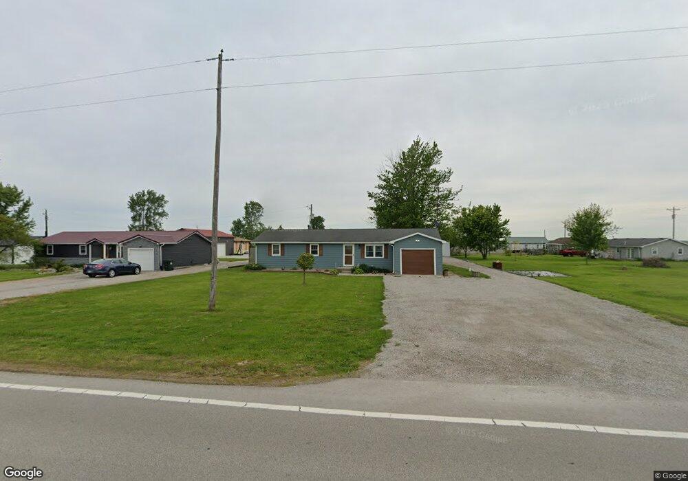
7951 State Route 111 Paulding, OH 45879
Estimated Value: $141,655 - $179,000
3
Beds
2
Baths
1,176
Sq Ft
$136/Sq Ft
Est. Value
About This Home
This home is located at 7951 State Route 111, Paulding, OH 45879 and is currently estimated at $159,914, approximately $135 per square foot. 7951 State Route 111 is a home located in Paulding County with nearby schools including Paulding High School.
Ownership History
Date
Name
Owned For
Owner Type
Purchase Details
Closed on
Sep 3, 2021
Sold by
Bohner Brent A and Bohner Mackenzie A
Bought by
Hire Michelle
Current Estimated Value
Home Financials for this Owner
Home Financials are based on the most recent Mortgage that was taken out on this home.
Original Mortgage
$135,327
Outstanding Balance
$121,788
Interest Rate
2.8%
Mortgage Type
New Conventional
Estimated Equity
$38,126
Purchase Details
Closed on
Nov 5, 2015
Sold by
Noneman Lowell D
Bought by
Bohner Brent A
Home Financials for this Owner
Home Financials are based on the most recent Mortgage that was taken out on this home.
Original Mortgage
$50,925
Interest Rate
3.87%
Mortgage Type
New Conventional
Purchase Details
Closed on
Aug 29, 1988
Bought by
Bohner Brent A
Create a Home Valuation Report for This Property
The Home Valuation Report is an in-depth analysis detailing your home's value as well as a comparison with similar homes in the area
Purchase History
| Date | Buyer | Sale Price | Title Company |
|---|---|---|---|
| Hire Michelle | $140,000 | None Available | |
| Bohner Brent A | $52,500 | None Available | |
| Bohner Brent A | $33,300 | -- |
Source: Public Records
Mortgage History
| Date | Status | Borrower | Loan Amount |
|---|---|---|---|
| Open | Hire Michelle | $135,327 | |
| Previous Owner | Bohner Brent A | $50,925 |
Source: Public Records
Tax History
| Year | Tax Paid | Tax Assessment Tax Assessment Total Assessment is a certain percentage of the fair market value that is determined by local assessors to be the total taxable value of land and additions on the property. | Land | Improvement |
|---|---|---|---|---|
| 2025 | $1,504 | $46,140 | $3,680 | $42,460 |
| 2024 | $1,504 | $35,500 | $2,840 | $32,660 |
| 2023 | $1,237 | $35,500 | $2,840 | $32,660 |
| 2022 | $1,205 | $35,500 | $2,840 | $32,660 |
| 2021 | $671 | $18,620 | $2,520 | $16,100 |
| 2020 | $694 | $18,620 | $2,520 | $16,100 |
| 2019 | $700 | $17,150 | $2,520 | $14,630 |
| 2018 | $650 | $17,150 | $2,520 | $14,630 |
| 2017 | $651 | $17,150 | $2,520 | $14,630 |
| 2016 | $651 | $17,150 | $2,520 | $14,630 |
| 2015 | $680 | $18,170 | $4,100 | $14,070 |
| 2014 | $676 | $18,170 | $4,100 | $14,070 |
| 2013 | $746 | $18,170 | $4,100 | $14,070 |
Source: Public Records
Map
Nearby Homes
- 11051 Road 93
- 4337 Road 162
- 780 W Jackson St
- 717 W Harrison St
- 714 W Wayne St
- 614 W Jackson St
- 215 N Dewitt St
- 520 W Wayne St
- 508 W Jackson St
- 214 Weber St
- 212 Weber St
- 210 Weber St
- 314 E Canal St
- 106 Buffalo St
- 830 N Walnut St
- 516 N Williams St
- 780 N Williams St
- 301 N Main St
- 6306 Road 55
- 412 S Laura St
- 7935 State Route 111
- 11025 Road 71
- 11037 Road 71
- 7905 State Route 111
- 11051 Road 71
- 7887 State Route 111
- 11071 Road 71
- 7871 State Route 111
- 7871 Sr 111
- 7856 State Route 111
- 11201 Road 71
- 7621 State Route 111
- 7658 State Route 111
- 7484 State Route 111
- 7401 State Route 111
- 8668 State Route 111
- 8019 Road 144
Your Personal Tour Guide
Ask me questions while you tour the home.