
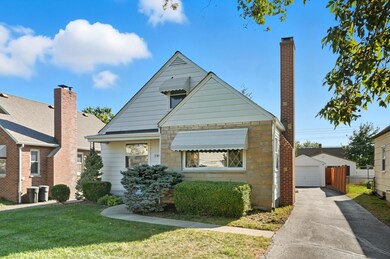
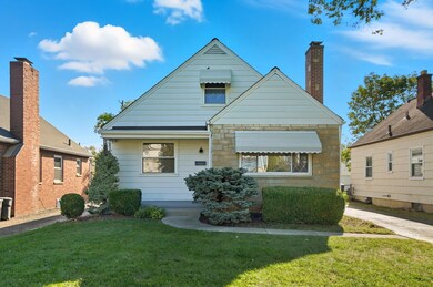
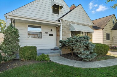
796 Binns Blvd Columbus, OH 43204
Southwest Hilltop NeighborhoodEstimated payment $1,197/month
Highlights
- Cape Cod Architecture
- No HOA
- Patio
- Main Floor Primary Bedroom
- 1 Car Detached Garage
- Forced Air Heating and Cooling System
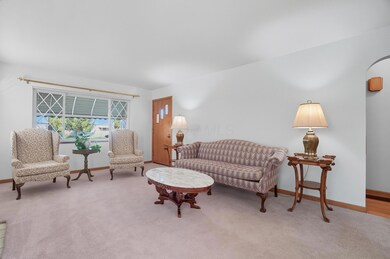
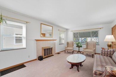
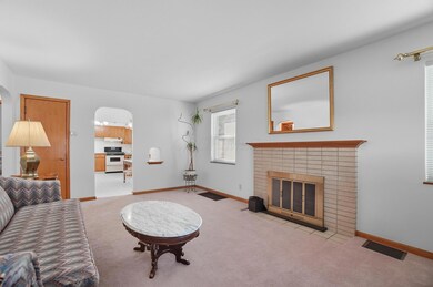
About This Home
Welcome to 796 Binns Blvd. Charming and well-maintained, this home offers 3 bedrooms, 2 full bathrooms, and a sitting room—perfect for a home office. The spacious kitchen features built-ins and great potential to update to your taste. A full basement offers generous storage or the option to finish for added living space. Outside, there is a detached 1-car garage and a nice yard area. This home has been meticulously maintained, and it shows. This is a great opportunity for a beautiful home you can add your touch to!
Home Details
Home Type
- Single Family
Est. Annual Taxes
- $2,385
Year Built
- Built in 1951
Parking
- 1 Car Detached Garage
Home Design
- Cape Cod Architecture
- Block Foundation
Interior Spaces
- 1,291 Sq Ft Home
- 2-Story Property
- Gas Log Fireplace
- Basement Fills Entire Space Under The House
- Gas Range
- Laundry on lower level
Bedrooms and Bathrooms
- 3 Bedrooms | 1 Primary Bedroom on Main
Utilities
- Forced Air Heating and Cooling System
- Heating System Uses Gas
Additional Features
- Patio
- 4,792 Sq Ft Lot
Community Details
- No Home Owners Association
Listing and Financial Details
- Assessor Parcel Number 010-069112
Map
Home Values in the Area
Average Home Value in this Area
Tax History
| Year | Tax Paid | Tax Assessment Tax Assessment Total Assessment is a certain percentage of the fair market value that is determined by local assessors to be the total taxable value of land and additions on the property. | Land | Improvement |
|---|---|---|---|---|
| 2024 | $2,385 | $53,140 | $12,500 | $40,640 |
| 2023 | $2,354 | $53,130 | $12,495 | $40,635 |
| 2022 | $1,821 | $35,110 | $4,620 | $30,490 |
| 2021 | $1,824 | $35,110 | $4,620 | $30,490 |
| 2020 | $1,827 | $35,110 | $4,620 | $30,490 |
| 2019 | $1,752 | $28,880 | $3,850 | $25,030 |
| 2018 | $874 | $28,880 | $3,850 | $25,030 |
| 2017 | $1,751 | $28,880 | $3,850 | $25,030 |
| 2016 | $1,630 | $24,610 | $4,060 | $20,550 |
| 2015 | $740 | $24,610 | $4,060 | $20,550 |
| 2014 | $1,484 | $24,610 | $4,060 | $20,550 |
| 2013 | $860 | $28,910 | $4,760 | $24,150 |
Property History
| Date | Event | Price | List to Sale | Price per Sq Ft |
|---|---|---|---|---|
| 10/02/2025 10/02/25 | For Sale | $189,900 | -- | $147 / Sq Ft |
Purchase History
| Date | Type | Sale Price | Title Company |
|---|---|---|---|
| Quit Claim Deed | -- | None Listed On Document | |
| Quit Claim Deed | -- | None Listed On Document | |
| Quit Claim Deed | -- | None Listed On Document | |
| Warranty Deed | -- | -- | |
| Deed | $57,000 | -- | |
| Deed | -- | -- | |
| Deed | $45,000 | -- |
Source: Columbus and Central Ohio Regional MLS
MLS Number: 225037360
APN: 010-069112
Disclaimer: Certain information contained herein is derived from information provided by parties other than Homes.com. All information provided is deemed reliable, but is not guaranteed to be accurate and should be independently verified.
![]() IDX information is provided exclusively for personal, non-commercial use, and may not be used for any purpose other than to identify prospective properties consumers may be interested in purchasing.
IDX information is provided exclusively for personal, non-commercial use, and may not be used for any purpose other than to identify prospective properties consumers may be interested in purchasing.
Information is deemed reliable but not guaranteed.
- 793 Binns Blvd
- 828 Binns Blvd
- 3103 Vanderberg Ave
- 840 S Roys Ave
- 890 S Roys Ave
- 898 Chestershire Rd
- 3029 Rosedale Ave
- 638 Binns Blvd
- 610 Salisbury Rd
- 737 S Brinker Ave
- 804 S Hague Ave
- 733 S Hague Ave
- 903 S Harris Ave
- 1037 Chestershire Rd
- 690 S Hague Ave
- 840 Mark Place
- 2783-2785 Vanderberg Ave
- 790 Racine Ave
- 3318 Miriam Dr S
- 805 S Warren Ave
- 821 S Harris Ave
- 914 S Harris Ave
- 2895 Sullivant Ave
- 453 S Powell Ave
- 587 S Ogden Ave
- 661 S Burgess Ave
- 599 S Burgess Ave Unit 601
- 2911 N Gresham Rd
- 341 S Roys Ave
- 825 S Terrace Ave
- 706 S Richardson Ave
- 534 S Richardson Ave
- 633 S Terrace Ave
- 478 S Richardson Ave Unit 2
- 661 S Eureka Ave
- 299 S Warren Ave
- 2727 Hafton Rd
- 751 Kingsford Rd Unit C
- 3399 Clime Rd
- 195 S Sylvan Ave
