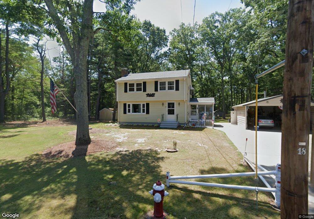
797 Warren Ave Swansea, MA 02777
Monroes-South Seekonk NeighborhoodEstimated Value: $463,000 - $523,000
3
Beds
2
Baths
1,344
Sq Ft
$361/Sq Ft
Est. Value
About This Home
This home is located at 797 Warren Ave, Swansea, MA 02777 and is currently estimated at $485,031, approximately $360 per square foot. 797 Warren Ave is a home located in Bristol County with nearby schools including Joseph Case High School, Barrington Christian Academy, and St. Andrews School.
Ownership History
Date
Name
Owned For
Owner Type
Purchase Details
Closed on
Oct 10, 2024
Sold by
Silva Linda L
Bought by
Lida Lee Silva Irt and Rowan
Current Estimated Value
Purchase Details
Closed on
Jan 19, 2024
Sold by
Silva Robert D and Silva Linda L
Bought by
Silva Linda L
Purchase Details
Closed on
Jul 23, 2008
Sold by
Silva Robert D
Bought by
Silva Linda L and Silva Robert D
Create a Home Valuation Report for This Property
The Home Valuation Report is an in-depth analysis detailing your home's value as well as a comparison with similar homes in the area
Home Values in the Area
Average Home Value in this Area
Purchase History
| Date | Buyer | Sale Price | Title Company |
|---|---|---|---|
| Lida Lee Silva Irt | -- | None Available | |
| Lida Lee Silva Irt | -- | None Available | |
| Silva Linda L | -- | None Available | |
| Silva Linda L | -- | None Available | |
| Silva Linda L | -- | -- | |
| Silva Linda L | -- | -- | |
| Silva Linda L | -- | -- |
Source: Public Records
Tax History Compared to Growth
Tax History
| Year | Tax Paid | Tax Assessment Tax Assessment Total Assessment is a certain percentage of the fair market value that is determined by local assessors to be the total taxable value of land and additions on the property. | Land | Improvement |
|---|---|---|---|---|
| 2025 | $4,410 | $370,000 | $178,000 | $192,000 |
| 2024 | $4,424 | $369,000 | $178,000 | $191,000 |
| 2023 | $4,011 | $305,500 | $130,900 | $174,600 |
| 2022 | $3,845 | $267,200 | $119,200 | $148,000 |
| 2021 | $3,925 | $251,100 | $119,200 | $131,900 |
| 2020 | $3,900 | $250,300 | $119,200 | $131,100 |
| 2019 | $3,802 | $245,100 | $106,600 | $138,500 |
| 2018 | $3,696 | $241,900 | $104,900 | $137,000 |
| 2017 | $3,194 | $240,500 | $104,900 | $135,600 |
| 2016 | $3,020 | $223,400 | $90,600 | $132,800 |
| 2015 | $2,929 | $223,100 | $90,600 | $132,500 |
| 2014 | $2,740 | $213,400 | $90,600 | $122,800 |
Source: Public Records
Map
Nearby Homes
- 7 Cheshire Dr
- 15 George w Finnerty Rd
- 4 Old Chimney Rd
- 5 George St
- 15 Lamson Rd
- 7 Wright Place
- 19 Evergreen St
- 3 Pine Top Rd
- 1261 Grand Army of the Republic Hwy
- 7 Simmons Rd
- 43 Baptist St
- 20 Burr Ave
- 6 Plymouth Dr
- 23 Pine Top Rd
- 7 Jill Ct
- 15 Stanhope Dr
- 72 School St
- 3 Kenmore Ct
- 6 Kenmore Ct
- 6 Hazelton Rd
- 775 Warren Ave
- 827 Warren Ave
- 10 Hollister Rd
- 151 New Meadow Rd
- 11 Hollister Rd
- 804 Warren Ave
- 764 Warren Ave
- 758 Warren Ave
- 820 Warren Ave
- 27 Hollister Rd
- 750 Warren Ave
- 30 Hollister Rd
- 142 New Meadow Rd
- 39 Hollister Rd
- 39 Hollister Rd
- 39 Hollister Rd Unit 1
- 141 New Meadow Rd
- 853 Warren Ave
- 748 Warren Ave
- 140 New Meadow Rd