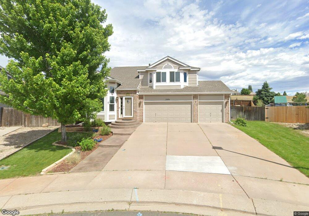
7970 Henslow Ct Colorado Springs, CO 80920
Briargate NeighborhoodEstimated Value: $533,000 - $593,000
4
Beds
4
Baths
2,060
Sq Ft
$273/Sq Ft
Est. Value
About This Home
This home is located at 7970 Henslow Ct, Colorado Springs, CO 80920 and is currently estimated at $562,426, approximately $273 per square foot. 7970 Henslow Ct is a home located in El Paso County with nearby schools including Prairie Hills Elementary School, Timberview Middle School, and Liberty High School.
Ownership History
Date
Name
Owned For
Owner Type
Purchase Details
Closed on
Jun 4, 2015
Sold by
Taggart Theodore Peter and Taggart Suzanne Murphy
Bought by
The Taggart Family Living Trust
Current Estimated Value
Purchase Details
Closed on
Sep 6, 1996
Sold by
Richmond Homes Inc Ii
Bought by
Taggart Theodore Peter and Taggart Suzanne Murphy
Home Financials for this Owner
Home Financials are based on the most recent Mortgage that was taken out on this home.
Original Mortgage
$150,550
Outstanding Balance
$12,973
Interest Rate
8.24%
Estimated Equity
$549,453
Create a Home Valuation Report for This Property
The Home Valuation Report is an in-depth analysis detailing your home's value as well as a comparison with similar homes in the area
Home Values in the Area
Average Home Value in this Area
Purchase History
| Date | Buyer | Sale Price | Title Company |
|---|---|---|---|
| The Taggart Family Living Trust | -- | None Available | |
| Taggart Theodore Peter | $189,120 | Land Title |
Source: Public Records
Mortgage History
| Date | Status | Borrower | Loan Amount |
|---|---|---|---|
| Open | Taggart Theodore Peter | $150,550 |
Source: Public Records
Tax History Compared to Growth
Tax History
| Year | Tax Paid | Tax Assessment Tax Assessment Total Assessment is a certain percentage of the fair market value that is determined by local assessors to be the total taxable value of land and additions on the property. | Land | Improvement |
|---|---|---|---|---|
| 2025 | $2,331 | $38,410 | -- | -- |
| 2024 | $2,301 | $40,020 | $5,360 | $34,660 |
| 2023 | $2,301 | $40,020 | $5,360 | $34,660 |
| 2022 | $1,902 | $26,950 | $4,340 | $22,610 |
| 2021 | $2,103 | $27,720 | $4,460 | $23,260 |
| 2020 | $2,033 | $24,980 | $3,720 | $21,260 |
| 2019 | $2,013 | $24,980 | $3,720 | $21,260 |
| 2018 | $1,755 | $21,420 | $2,880 | $18,540 |
| 2017 | $1,748 | $21,420 | $2,880 | $18,540 |
| 2016 | $1,960 | $23,980 | $2,930 | $21,050 |
| 2015 | $1,956 | $23,980 | $2,930 | $21,050 |
| 2014 | $1,763 | $21,600 | $2,930 | $18,670 |
Source: Public Records
Map
Nearby Homes
- 4255 Scotch Pine Dr
- 8110 Lythrum Dr
- 8230 Camfield Cir
- 7950 Sangor Dr
- 4035 Scotch Pine Dr
- 4120 Limberwood Ct
- 4955 Ramblewood Dr
- 4315 Basswood Dr
- 4465 Archwood Dr
- 4455 Archwood Dr
- 8138 Steadman Dr
- 8030 Chancellor Dr
- 8315 Capewood Ct
- 7866 Brandy Cir
- 3895 Beltana Dr
- 8330 Pepperridge Dr
- 4865 Criswell Ct
- 4564 Peak Crest View
- 4684 Peak Crest View
- 3855 Beltana Dr
- 7960 Henslow Ct
- 7980 Henslow Ct
- 7950 Henslow Ct
- 7975 Henslow Ct
- 7940 Henslow Ct
- 7965 Henslow Ct
- 7955 Henslow Ct
- 7902 Antelope Ridge Point
- 7925 Henslow Ct
- 7930 Henslow Ct
- 7878 Antelope Ridge Point
- 7926 Antelope Ridge Point
- 7854 Antelope Ridge Point
- 7920 Henslow Ct
- 7913 Antelope Ridge Point
- 7950 Antelope Ridge Point
- 7910 Henslow Ct
- 7865 Antelope Ridge Point
- 7941 Silver Maple Ln
- 4185 Scotch Pine Dr