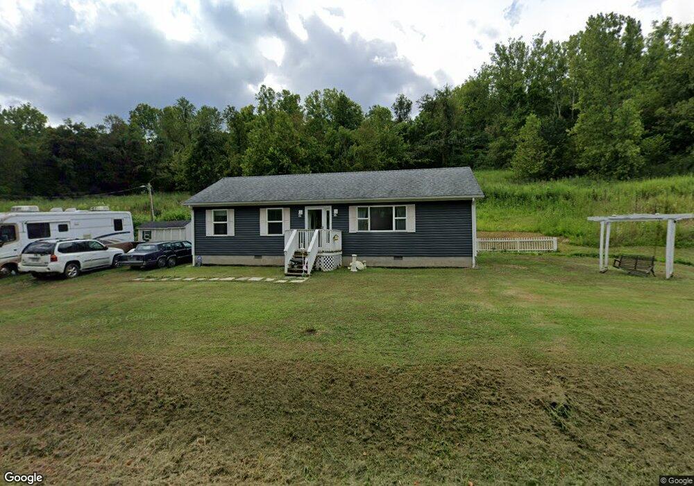
7976 State Route 243 South Point, OH 45680
Estimated Value: $119,000 - $171,670
2
Beds
1
Bath
1,152
Sq Ft
$134/Sq Ft
Est. Value
About This Home
This home is located at 7976 State Route 243, South Point, OH 45680 and is currently estimated at $154,668, approximately $134 per square foot. 7976 State Route 243 is a home with nearby schools including Dawson-Bryant Elementary School, Dawson-Bryant Middle School, and Dawson-Bryant High School.
Ownership History
Date
Name
Owned For
Owner Type
Purchase Details
Closed on
Jan 9, 2014
Sold by
Rice Carl A and Rice Helen Virginia
Bought by
Markins Debbie L and Jenkins Debbie
Current Estimated Value
Home Financials for this Owner
Home Financials are based on the most recent Mortgage that was taken out on this home.
Original Mortgage
$39,500
Interest Rate
3.5%
Mortgage Type
Adjustable Rate Mortgage/ARM
Purchase Details
Closed on
Oct 8, 1997
Sold by
Rice James E and Rice Betty D
Bought by
Rice James E and Rice Betty D
Purchase Details
Closed on
Jun 27, 1997
Sold by
Rice James E and Rice Betty D
Bought by
Rice James E and Rice Betty D
Purchase Details
Closed on
Jul 12, 1996
Sold by
Rice James E and Rice Betty D
Bought by
Rice James E and Rice Betty D
Purchase Details
Closed on
May 12, 1993
Sold by
Rice Carl A and Rice James E
Bought by
Rice James E and Rice Betty D
Create a Home Valuation Report for This Property
The Home Valuation Report is an in-depth analysis detailing your home's value as well as a comparison with similar homes in the area
Home Values in the Area
Average Home Value in this Area
Purchase History
| Date | Buyer | Sale Price | Title Company |
|---|---|---|---|
| Markins Debbie L | $21,000 | None Available | |
| Rice James E | -- | -- | |
| Rice James E | -- | -- | |
| Rice James E | -- | -- | |
| Rice James E | -- | -- |
Source: Public Records
Mortgage History
| Date | Status | Borrower | Loan Amount |
|---|---|---|---|
| Closed | Markins Debbie L | $39,500 |
Source: Public Records
Tax History Compared to Growth
Tax History
| Year | Tax Paid | Tax Assessment Tax Assessment Total Assessment is a certain percentage of the fair market value that is determined by local assessors to be the total taxable value of land and additions on the property. | Land | Improvement |
|---|---|---|---|---|
| 2024 | -- | $42,790 | $6,290 | $36,500 |
| 2023 | $1,216 | $42,790 | $6,290 | $36,500 |
| 2022 | $1,213 | $42,790 | $6,290 | $36,500 |
| 2021 | $1,295 | $43,970 | $5,870 | $38,100 |
| 2020 | $239 | $7,570 | $5,870 | $1,700 |
| 2019 | $244 | $7,850 | $5,870 | $1,980 |
| 2018 | $242 | $7,690 | $5,750 | $1,940 |
| 2017 | $241 | $7,690 | $5,750 | $1,940 |
| 2016 | $221 | $7,690 | $5,750 | $1,940 |
| 2015 | $216 | $7,230 | $4,630 | $2,600 |
| 2014 | $216 | $7,230 | $4,630 | $2,600 |
| 2013 | $216 | $7,230 | $4,630 | $2,600 |
Source: Public Records
Map
Nearby Homes
- 9040 Ohio 243
- 6881 State Route 243
- 1122 Township Road 266
- 1122 Township Road 266
- 66 County Road 30
- 4404 County Road 15
- 66 Township Road 1523
- 3569 County Road 6
- 3493 County Road 31
- 25 Township Road 1524
- 3171 County Road 31
- 1225 County Road 15
- 48 Private Drive 1179
- 859 County Road 53
- 885 County Road 53
- 119 County Road 15
- 719 County Road 15
- 6757 County Road 15
- 6897 County Road 15
- 571 County Road 52
- 7863 State Route 243
- 8098 State Route 243
- 7842 State Route 243
- 7842 State Route 243
- 8114 State Route 243
- 253 Ohio 243 Unit 1357
- 8191 State Route 243
- 8208 State Route 243
- 651 Township Road 250
- 7685 State Route 243
- 171 Township Road 117
- 8256 State Route 243
- 547 Township Road 250
- 7512 State Route 243
- 771 Township Road 250
- 771 Township Road 250 Unit JO-42
- 771 Township Road 250 Unit JO-1
- 7561 State Route 243
- 8394 State Route 243
- 8208 Ohio 243