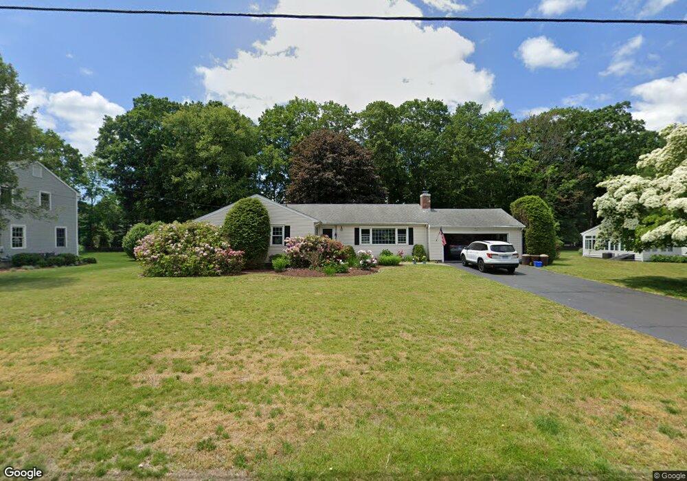
798 Mountain Laurel Rd Fairfield, CT 06824
Lake Mohegan Hills NeighborhoodEstimated Value: $870,897 - $1,075,000
3
Beds
3
Baths
1,677
Sq Ft
$566/Sq Ft
Est. Value
About This Home
This home is located at 798 Mountain Laurel Rd, Fairfield, CT 06824 and is currently estimated at $949,474, approximately $566 per square foot. 798 Mountain Laurel Rd is a home located in Fairfield County with nearby schools including Burr Elementary School, Tomlinson Middle School, and Fairfield Warde High School.
Ownership History
Date
Name
Owned For
Owner Type
Purchase Details
Closed on
Jan 12, 2018
Sold by
Carr Charles N
Bought by
Carr Charles N and Carr Jillian L
Current Estimated Value
Home Financials for this Owner
Home Financials are based on the most recent Mortgage that was taken out on this home.
Original Mortgage
$418,680
Outstanding Balance
$352,954
Interest Rate
3.9%
Mortgage Type
Purchase Money Mortgage
Estimated Equity
$596,520
Purchase Details
Closed on
Apr 30, 1997
Sold by
Suthern Curtis A and Suthern Virginia W
Bought by
Carr Helen W
Create a Home Valuation Report for This Property
The Home Valuation Report is an in-depth analysis detailing your home's value as well as a comparison with similar homes in the area
Home Values in the Area
Average Home Value in this Area
Purchase History
| Date | Buyer | Sale Price | Title Company |
|---|---|---|---|
| Carr Charles N | $505,000 | -- | |
| Carr Charles N | $505,000 | -- | |
| Carr Helen W | $350,000 | -- | |
| Carr Helen W | $350,000 | -- |
Source: Public Records
Mortgage History
| Date | Status | Borrower | Loan Amount |
|---|---|---|---|
| Open | Carr Helen W | $418,680 | |
| Closed | Carr Helen W | $418,680 | |
| Previous Owner | Carr Helen W | $170,000 |
Source: Public Records
Tax History Compared to Growth
Tax History
| Year | Tax Paid | Tax Assessment Tax Assessment Total Assessment is a certain percentage of the fair market value that is determined by local assessors to be the total taxable value of land and additions on the property. | Land | Improvement |
|---|---|---|---|---|
| 2025 | $9,303 | $327,670 | $216,860 | $110,810 |
| 2024 | $9,142 | $327,670 | $216,860 | $110,810 |
| 2023 | $9,014 | $327,670 | $216,860 | $110,810 |
| 2022 | $8,926 | $327,670 | $216,860 | $110,810 |
| 2021 | $8,841 | $327,670 | $216,860 | $110,810 |
| 2020 | $8,129 | $303,450 | $188,160 | $115,290 |
| 2019 | $8,129 | $303,450 | $188,160 | $115,290 |
| 2018 | $7,999 | $303,450 | $188,160 | $115,290 |
| 2017 | $7,835 | $303,450 | $188,160 | $115,290 |
| 2016 | $7,723 | $303,450 | $188,160 | $115,290 |
| 2015 | $7,641 | $308,210 | $208,110 | $100,100 |
| 2014 | $7,520 | $308,210 | $208,110 | $100,100 |
Source: Public Records
Map
Nearby Homes
- 210 Pansy Rd
- 947 Galloping Hill Rd
- 750 Burr St
- 706 Judd St
- 1137 Stillson Rd
- 31 High Ridge Rd
- 28 Stillson Place
- 1165 Stillson Rd
- 99 Old Academy Rd
- 2107 N Benson Rd
- 251 Winnepoge Dr
- 1207 Stillson Rd
- 115 Mayfair Rd
- 79 Mayfair Rd
- 109 Buckboard Ln
- 25 Millspaugh Dr
- 338 Orchard Hill Ln
- 2959 Congress St
- 2492 Congress St
- 359 Reid St
- 820 Mountain Laurel Rd
- 766 Mountain Laurel Rd Unit Furn
- 766 Mountain Laurel Rd Unit Unfurn
- 766 Mountain Laurel Rd
- 722 Mountain Laurel Rd
- 850 Mountain Laurel Rd
- 789 Mountain Laurel Rd
- 817 Mountain Laurel Rd
- 140 Stroll Rock Common
- 739 Mountain Laurel Rd
- 845 Mountain Laurel Rd
- 125 Stroll Rock Common
- 120 Stroll Rock Common
- 652 Mountain Laurel Rd
- 38 Oriole Ln
- 872 Mountain Laurel Rd
- 55 Oriole Ln
- 60 Oriole Ln
- 150 Stroll Rock Common
- 296 Springer Rd