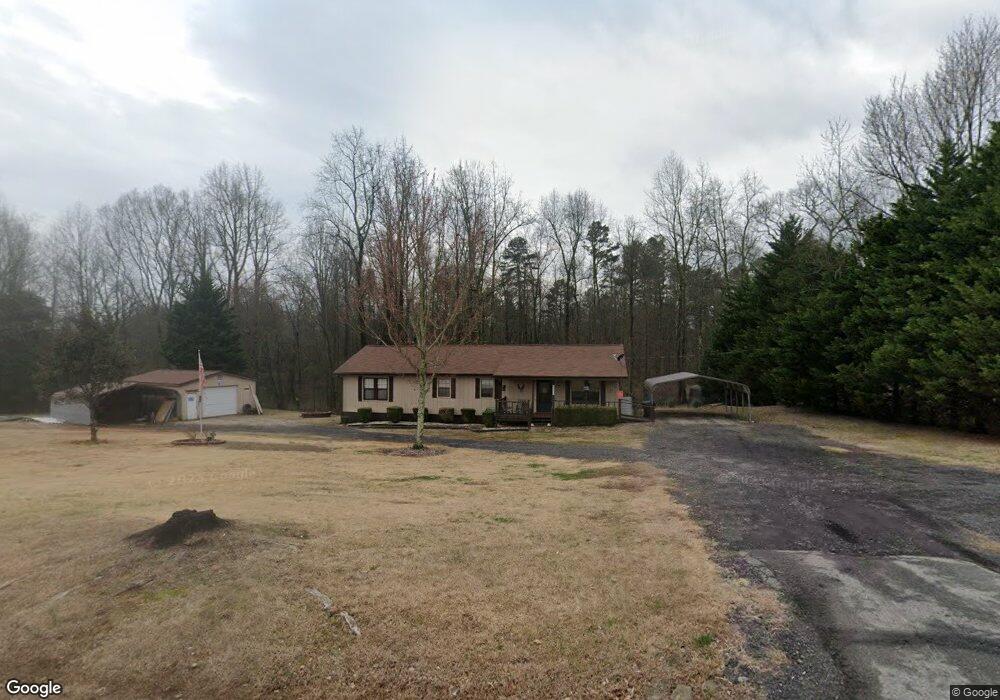
7980 Dawsonville Hwy Dawsonville, GA 30534
Estimated Value: $164,621 - $365,000
3
Beds
2
Baths
1,674
Sq Ft
$143/Sq Ft
Est. Value
About This Home
This home is located at 7980 Dawsonville Hwy, Dawsonville, GA 30534 and is currently estimated at $238,655, approximately $142 per square foot. 7980 Dawsonville Hwy is a home located in Lumpkin County with nearby schools including Lumpkin County High School and Bay Creek Christian Academy.
Ownership History
Date
Name
Owned For
Owner Type
Purchase Details
Closed on
Sep 16, 2024
Sold by
Jones Glenda M
Bought by
Jones David Brian
Current Estimated Value
Purchase Details
Closed on
Jan 9, 2014
Sold by
Dove Glenda Rebecca Mcdani
Bought by
Dove Glenda Mcdainel
Purchase Details
Closed on
Jun 30, 2012
Sold by
Dove Jeffrey Wade
Bought by
Dove Glenda Rebecca
Purchase Details
Closed on
Jun 30, 2010
Sold by
Dove Jeffrey Wade Dove Glenda
Bought by
Dove Glenda Rebecca
Purchase Details
Closed on
Jun 12, 2003
Sold by
Dove Jeffrey Wade Dove Glenda
Bought by
Dove Jeffrey Wade Dove Glenda Rebec
Purchase Details
Closed on
Sep 1, 1986
Sold by
Thompson Timothy
Bought by
Prescott Ralph
Purchase Details
Closed on
Apr 1, 1983
Bought by
Thompson Timothy
Create a Home Valuation Report for This Property
The Home Valuation Report is an in-depth analysis detailing your home's value as well as a comparison with similar homes in the area
Home Values in the Area
Average Home Value in this Area
Purchase History
| Date | Buyer | Sale Price | Title Company |
|---|---|---|---|
| Jones David Brian | $160,499 | -- | |
| Dove Glenda Mcdainel | -- | -- | |
| Dove Glenda Rebecca | -- | -- | |
| Dove Glenda Rebecca | -- | -- | |
| Dove Jeffrey Wade Dove Glenda Rebec | -- | -- | |
| Dove Jeffrey Wade Dove Glenda Rebec | $100,000 | -- | |
| Prescott Ralph | -- | -- | |
| Thompson Timothy | $37,000 | -- |
Source: Public Records
Tax History Compared to Growth
Tax History
| Year | Tax Paid | Tax Assessment Tax Assessment Total Assessment is a certain percentage of the fair market value that is determined by local assessors to be the total taxable value of land and additions on the property. | Land | Improvement |
|---|---|---|---|---|
| 2024 | $56 | $68,386 | $8,080 | $60,306 |
| 2023 | $1 | $64,199 | $7,551 | $56,648 |
| 2022 | $1,416 | $57,186 | $6,293 | $50,893 |
| 2021 | $1,434 | $50,534 | $6,293 | $44,241 |
| 2020 | $1,397 | $49,245 | $6,031 | $43,214 |
| 2019 | $1,397 | $49,245 | $6,031 | $43,214 |
| 2018 | $1,289 | $45,443 | $6,031 | $39,412 |
| 2017 | $0 | $45,843 | $6,031 | $39,812 |
| 2016 | -- | $41,674 | $6,031 | $35,643 |
| 2015 | $1,115 | $41,674 | $6,031 | $35,643 |
| 2014 | $1,115 | $42,289 | $6,031 | $36,258 |
| 2013 | -- | $42,903 | $6,031 | $36,872 |
Source: Public Records
Map
Nearby Homes
- 0 Rider Rd Unit 7481902
- 0 Rider Rd Unit 10408283
- 27 Bryn Ct
- 50 Hannahs Ct
- 382 Candler Ln
- 0x Pink Williams Rd
- 0x Pink Williams Rd Unit 124AC
- 120 Kings Crossing Dr
- 6380 Dawsonville Hwy
- 66 Patriot Trail
- 322 Miller Dr
- 3050 Burt Creek Rd
- 771 Rattlesnake Ridge
- 136 Morgan Ln
- 114 Morgan Ln
- 23 Morgan Ln
- 174 Morgan Ln
- 437 Morgan Ln
- 7952 Dawsonville Hwy
- 0 Rider Rd
- 0 Rider Rd Unit 10145264
- 0 Rider Rd Unit 10144613
- 0 Rider Rd Unit 7182072
- 0 Rider Rd Unit 10027098
- 0 Rider Rd Unit 7013227
- 0 Rider Rd Unit 20007260
- 0 Rider Rd Unit 6981428
- 0 Rider Rd Unit 3237426
- 0 Rider Rd Unit 8838570
- 0 Rider Rd Unit 7593669
- 0 Rider Rd Unit 7582006
- 0 Rider Rd Unit 8876284
- 0 Rider Rd Unit 8848757
- 0 Rider Rd Unit 8848754
- 0 Rider Rd Unit 9065953
- 0 Rider Rd Unit 6956822
- 0 Rider Rd Unit 8243140
- 400 Bryndemere Dr