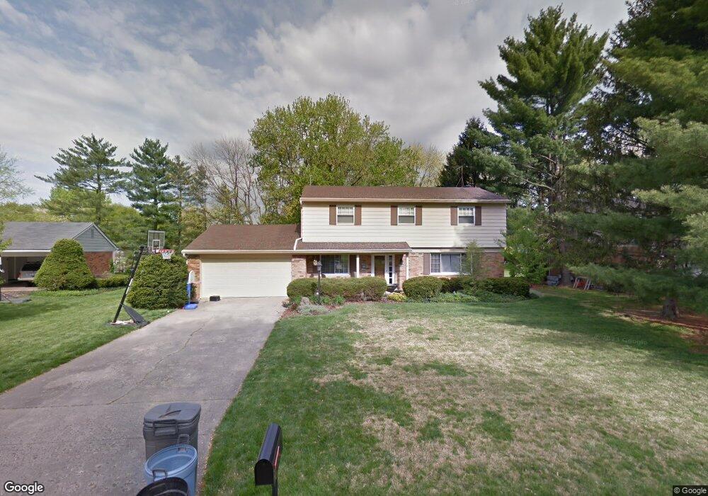
799 Ackley Rd Cincinnati, OH 45255
Estimated Value: $325,000 - $395,000
4
Beds
3
Baths
1,989
Sq Ft
$186/Sq Ft
Est. Value
About This Home
This home is located at 799 Ackley Rd, Cincinnati, OH 45255 and is currently estimated at $370,070, approximately $186 per square foot. 799 Ackley Rd is a home located in Hamilton County with nearby schools including Ayer Elementary School, Nagel Middle School, and Anderson High School.
Ownership History
Date
Name
Owned For
Owner Type
Purchase Details
Closed on
Apr 18, 2002
Sold by
Cobb Naurine M Tr
Bought by
Robertson Derek T and Robertson Sarah L
Current Estimated Value
Home Financials for this Owner
Home Financials are based on the most recent Mortgage that was taken out on this home.
Original Mortgage
$163,875
Outstanding Balance
$66,691
Interest Rate
7.13%
Estimated Equity
$303,379
Purchase Details
Closed on
Nov 16, 1999
Sold by
Cobb Donald K and Cobb Naurine M
Bought by
Cobb Naurine M and Naurine M Cobb Revocable Trust
Create a Home Valuation Report for This Property
The Home Valuation Report is an in-depth analysis detailing your home's value as well as a comparison with similar homes in the area
Home Values in the Area
Average Home Value in this Area
Purchase History
| Date | Buyer | Sale Price | Title Company |
|---|---|---|---|
| Robertson Derek T | $172,500 | -- | |
| Cobb Naurine M | -- | -- |
Source: Public Records
Mortgage History
| Date | Status | Borrower | Loan Amount |
|---|---|---|---|
| Open | Robertson Derek T | $163,875 |
Source: Public Records
Tax History
| Year | Tax Paid | Tax Assessment Tax Assessment Total Assessment is a certain percentage of the fair market value that is determined by local assessors to be the total taxable value of land and additions on the property. | Land | Improvement |
|---|---|---|---|---|
| 2025 | $6,289 | $100,671 | $21,137 | $79,534 |
| 2023 | $5,814 | $100,671 | $21,137 | $79,534 |
| 2022 | $4,854 | $74,851 | $18,417 | $56,434 |
| 2021 | $4,739 | $74,851 | $18,417 | $56,434 |
| 2020 | $4,794 | $74,851 | $18,417 | $56,434 |
| 2019 | $4,673 | $66,242 | $16,300 | $49,942 |
| 2018 | $4,377 | $66,242 | $16,300 | $49,942 |
| 2017 | $4,128 | $66,242 | $16,300 | $49,942 |
| 2016 | $3,640 | $57,057 | $16,625 | $40,432 |
| 2015 | $3,536 | $57,057 | $16,625 | $40,432 |
| 2014 | $3,538 | $57,057 | $16,625 | $40,432 |
| 2013 | $3,280 | $55,938 | $16,300 | $39,638 |
Source: Public Records
Map
Nearby Homes
- 7988 Woodruff Rd
- 8016 Hignite Ct
- 881 Asbury Rd
- 7978 Nagel Village Dr
- 7754 Forest Rd
- 849 Shawnee Trace Ct
- 684 Balbriggan Ct
- 792 Farmsworth Ct
- 559 Asbury Rd
- 8303 Tidewater Ct
- 906 Woodlyn Dr N Unit 4
- 854 Woodlyn Dr S
- 965 Woodlyn Dr N
- 1357 Oak Ct
- 1363 Oak Ct
- 8512 Prilla Ln
- 8345 Cherry Ln
- 807 Nordyke Rd
- 1400 Sigma Cir
- 8022 Stonegate Dr
- 793 Ackley Rd
- 805 Ackley Rd
- 810 Kipp Dr
- 7987 Asbury Hills Dr
- 787 Ackley Rd
- 7971 Asbury Hills Dr
- 7949 Asbury Hills Dr
- 818 Kipp Dr
- 800 Kipp Dr
- 815 Ackley Rd
- 8007 Eastdale Dr
- 806 Ackley Rd
- 788 Ackley Rd
- 779 Ackley Rd
- 780 Kipp Dr
- 814 Ackley Rd
- 780 Ackley Rd
- 771 Ackley Rd
- 8017 Eastdale Dr
- 8024 Eastdale Dr