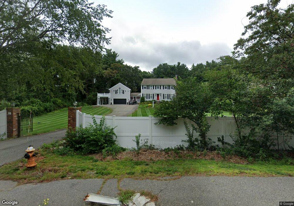
799 Hanover St Hanover, MA 02339
Estimated Value: $1,033,950 - $1,238,000
About This Home
This home is located at 799 Hanover St, Hanover, MA 02339 and is currently estimated at $1,133,488, approximately $364 per square foot. 799 Hanover St is a home located in Plymouth County with nearby schools including Hanover High School, Cadence Academy Preschool - Hanover, and The Master's Academy.
Ownership History
We collect this data history from publicly available records. To have your information removed, we recommend requesting removal directly through your county’s website.
Purchase Details
Home Values in the Area
Average Home Value in this Area
Purchase History
We collect this data history from publicly available records. To have your information removed, we recommend requesting removal directly through your county’s website.
| Date | Buyer | Sale Price | Title Company |
|---|---|---|---|
| -- | -- |
Mortgage History
We collect this data history from publicly available records. To have your information removed, we recommend requesting removal directly through your county’s website.
| Date | Status | Borrower | Loan Amount |
|---|---|---|---|
| Open | $300,000 | ||
| Closed | $200,000 | ||
| Closed | $100,000 | ||
| Closed | $25,000 |
Tax History
We collect this data history from publicly available records. To have your information removed, we recommend requesting removal directly through your county’s website.
| Year | Tax Paid | Tax Assessment Tax Assessment Total Assessment is a certain percentage of the fair market value that is determined by local assessors to be the total taxable value of land and additions on the property. | Land | Improvement |
|---|---|---|---|---|
| 2025 | $10,502 | $850,400 | $282,100 | $568,300 |
| 2024 | $10,227 | $796,500 | $282,100 | $514,400 |
| 2023 | $9,916 | $735,100 | $256,800 | $478,300 |
| 2022 | $10,190 | $668,200 | $244,100 | $424,100 |
| 2021 | $9,800 | $600,100 | $199,000 | $401,100 |
| 2020 | $5,386 | $594,500 | $210,600 | $383,900 |
| 2019 | $9,360 | $570,400 | $210,600 | $359,800 |
| 2018 | $8,734 | $536,500 | $210,600 | $325,900 |
| 2017 | $4,327 | $535,000 | $206,700 | $328,300 |
| 2016 | $8,585 | $509,200 | $188,100 | $321,100 |
| 2015 | $8,002 | $495,500 | $174,400 | $321,100 |
Map
- 17 Hammer Hook Dr
- 16 Cervelli Farm Dr
- 51 Cervelli Farm Dr
- 28 Cervelli Farm Dr
- 23 Cervelli Farm Dr
- 178 Main St
- 286 Mayflower Cir
- 250 Main St
- 221 Circuit St
- 113 Bradford Rd
- 28 Lantern Ln
- 114 Longwater Dr
- 63 Massasoit Ln
- 87 School St
- 42 Willow Rd
- 36 Monroe Rd
- 20 Jackson Rd
- 31 Osprey Ln
- 114 Graham Hill Dr
- 15 Rockland St
- 811 Hanover St
- 787 Hanover St
- 827 Hanover St
- 170 Grove St
- 56 Hawthorne Rd
- 769 Hanover St
- 29 Circuit St
- 10 Circuit St
- 44 Hawthorne Rd
- 44 Hawthorne Rd
- 843 Hanover St
- 32 Hawthorne Rd
- 786 Hanover St
- 20 Circuit St
- 168 Grove St
- 1 Hammer Hook Dr
- 20 Hawthorne Rd
- 766 Hanover St
- 176 Grove St
- 176 Grove St Unit 176
Ask me questions while you tour the home.