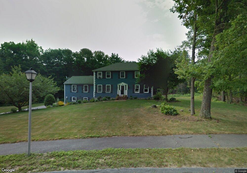
8 Almanac Way West Boylston, MA 01583
Estimated Value: $777,404 - $848,000
4
Beds
3
Baths
2,816
Sq Ft
$291/Sq Ft
Est. Value
About This Home
This home is located at 8 Almanac Way, West Boylston, MA 01583 and is currently estimated at $819,851, approximately $291 per square foot. 8 Almanac Way is a home located in Worcester County with nearby schools including Major Edwards Elementary School and West Boylston Junior/Senior High School.
Ownership History
Date
Name
Owned For
Owner Type
Purchase Details
Closed on
Nov 22, 2024
Sold by
Mullins Robert M and Mullins Jennifer B
Bought by
Mullins Robert M
Current Estimated Value
Purchase Details
Closed on
Aug 15, 2005
Sold by
Mcconnell Jennifer K and Mcconnell Michael
Bought by
Mullins Jennifer B and Mullins Robert M
Create a Home Valuation Report for This Property
The Home Valuation Report is an in-depth analysis detailing your home's value as well as a comparison with similar homes in the area
Home Values in the Area
Average Home Value in this Area
Purchase History
| Date | Buyer | Sale Price | Title Company |
|---|---|---|---|
| Mullins Robert M | -- | None Available | |
| Mullins Robert M | -- | None Available | |
| Mullins Jennifer B | $460,800 | -- | |
| Mullins Jennifer B | $460,800 | -- |
Source: Public Records
Mortgage History
| Date | Status | Borrower | Loan Amount |
|---|---|---|---|
| Previous Owner | Mullins Jennifer B | $322,500 | |
| Previous Owner | Mullins Jennifer B | $327,000 |
Source: Public Records
Tax History Compared to Growth
Tax History
| Year | Tax Paid | Tax Assessment Tax Assessment Total Assessment is a certain percentage of the fair market value that is determined by local assessors to be the total taxable value of land and additions on the property. | Land | Improvement |
|---|---|---|---|---|
| 2025 | $100 | $720,600 | $134,900 | $585,700 |
| 2024 | $9,671 | $654,300 | $138,700 | $515,600 |
| 2023 | $9,342 | $599,600 | $136,500 | $463,100 |
| 2022 | $8,898 | $503,300 | $140,300 | $363,000 |
| 2021 | $8,669 | $469,600 | $121,000 | $348,600 |
| 2020 | $8,093 | $435,600 | $124,200 | $311,400 |
| 2019 | $7,936 | $421,000 | $124,200 | $296,800 |
| 2018 | $7,554 | $403,500 | $124,200 | $279,300 |
| 2017 | $114 | $397,600 | $124,200 | $273,400 |
| 2016 | $7,398 | $401,000 | $115,500 | $285,500 |
| 2015 | $7,211 | $393,200 | $114,500 | $278,700 |
Source: Public Records
Map
Nearby Homes
- 16 N Main St
- 287 Laurel St
- 26 Townsend Dr
- 20 Winthrop St
- 136 Sterling St Unit A3
- 0 North St
- 0 Boutelle Rd
- 61 Boutelle Rd
- Lot 1 Manning St
- 2 Lakeview Ave
- 18 Laurel Ave
- 21 Myrtle Ave
- 223 Worcester Rd
- 156 Prospect St
- 152 Worcester St Unit 8
- 4 Jewett Rd Unit B
- 4 Jewett Rd Unit A
- 54 Maple St
- 62 Maple St
- 751 Mason Rd