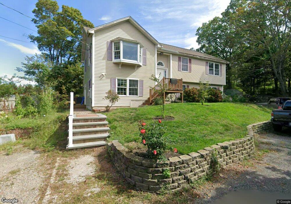
8 Armstrong Way Gloucester, MA 01930
Riverview NeighborhoodEstimated Value: $647,000 - $772,000
3
Beds
3
Baths
1,228
Sq Ft
$577/Sq Ft
Est. Value
About This Home
This home is located at 8 Armstrong Way, Gloucester, MA 01930 and is currently estimated at $708,486, approximately $576 per square foot. 8 Armstrong Way is a home located in Essex County with nearby schools including Plum Cove School, Ralph B O'maley Middle School, and Gloucester High School.
Ownership History
Date
Name
Owned For
Owner Type
Purchase Details
Closed on
Jul 21, 2021
Sold by
Barr Robert N and Barr Ann M
Bought by
Barr Ann M and Barr Justin
Current Estimated Value
Home Financials for this Owner
Home Financials are based on the most recent Mortgage that was taken out on this home.
Original Mortgage
$178,072
Outstanding Balance
$161,647
Interest Rate
2.93%
Mortgage Type
Stand Alone Refi Refinance Of Original Loan
Estimated Equity
$546,839
Purchase Details
Closed on
Nov 30, 1998
Sold by
Armstrong Michael E
Bought by
Barr Robert N and Barr Ann Marie
Create a Home Valuation Report for This Property
The Home Valuation Report is an in-depth analysis detailing your home's value as well as a comparison with similar homes in the area
Home Values in the Area
Average Home Value in this Area
Purchase History
| Date | Buyer | Sale Price | Title Company |
|---|---|---|---|
| Barr Ann M | -- | None Available | |
| Barr Ann M | -- | None Available | |
| Barr Robert N | $132,000 | -- | |
| Barr Robert N | $132,000 | -- |
Source: Public Records
Mortgage History
| Date | Status | Borrower | Loan Amount |
|---|---|---|---|
| Open | Barr Ann M | $178,072 | |
| Previous Owner | Barr Robert N | $40,900 | |
| Previous Owner | Barr Robert N | $200,000 | |
| Previous Owner | Barr Robert N | $192,000 |
Source: Public Records
Tax History Compared to Growth
Tax History
| Year | Tax Paid | Tax Assessment Tax Assessment Total Assessment is a certain percentage of the fair market value that is determined by local assessors to be the total taxable value of land and additions on the property. | Land | Improvement |
|---|---|---|---|---|
| 2025 | $5,749 | $590,900 | $154,500 | $436,400 |
| 2024 | $5,749 | $590,900 | $154,500 | $436,400 |
| 2023 | $5,424 | $512,200 | $137,900 | $374,300 |
| 2022 | $5,070 | $432,200 | $119,900 | $312,300 |
| 2021 | $4,983 | $400,600 | $109,000 | $291,600 |
| 2020 | $4,766 | $386,500 | $109,000 | $277,500 |
| 2019 | $4,818 | $379,700 | $109,000 | $270,700 |
| 2018 | $4,541 | $351,200 | $109,000 | $242,200 |
| 2017 | $4,284 | $324,800 | $103,900 | $220,900 |
| 2016 | $4,237 | $311,300 | $108,400 | $202,900 |
| 2015 | $4,144 | $303,600 | $108,400 | $195,200 |
Source: Public Records
Map
Nearby Homes
- 13 & 10 Ferry Hill Rd
- 273 Washington St Unit 2
- 28 Riverview Rd Unit B
- 3 Tidal Cove Way
- 7 Cove Way
- 18 Cherry St
- 6 Beauport Ave
- 24 Cobblestone Ln Unit 603
- 16 Reynard St
- 185 Washington St
- 5 Samoset Rd Unit A
- 12 Harold Ave
- 85 Centennial Ave
- 1 Alpine Ct
- 78 Grove St
- 13 Leslie o Johnson Rd
- 34 Cleveland St
- 8 Arthur St
- 8 Summer St Unit 103
- 13 1/2 Cleveland St