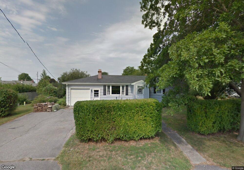
8 Cedar Ave Middletown, RI 02842
Estimated Value: $595,000 - $639,938
3
Beds
1
Bath
960
Sq Ft
$647/Sq Ft
Est. Value
About This Home
This home is located at 8 Cedar Ave, Middletown, RI 02842 and is currently estimated at $620,735, approximately $646 per square foot. 8 Cedar Ave is a home located in Newport County with nearby schools including Middletown High School, St Michael's Country Day School, and All Saints STEAM Academy.
Ownership History
Date
Name
Owned For
Owner Type
Purchase Details
Closed on
Jan 26, 2021
Sold by
Toland Samuel and Lako Samantha
Bought by
Toland Samuel
Current Estimated Value
Purchase Details
Closed on
Jan 7, 2021
Sold by
Toland Samuel
Bought by
Toland Samuel
Purchase Details
Closed on
Dec 9, 1998
Sold by
Phillips Victoria
Bought by
Toland Priscilla J
Home Financials for this Owner
Home Financials are based on the most recent Mortgage that was taken out on this home.
Original Mortgage
$60,000
Interest Rate
6.8%
Create a Home Valuation Report for This Property
The Home Valuation Report is an in-depth analysis detailing your home's value as well as a comparison with similar homes in the area
Home Values in the Area
Average Home Value in this Area
Purchase History
| Date | Buyer | Sale Price | Title Company |
|---|---|---|---|
| Toland Samuel | -- | None Available | |
| Toland Samuel | -- | None Available | |
| Toland Priscilla J | $120,000 | -- |
Source: Public Records
Mortgage History
| Date | Status | Borrower | Loan Amount |
|---|---|---|---|
| Previous Owner | Toland Priscilla J | $60,000 |
Source: Public Records
Tax History Compared to Growth
Tax History
| Year | Tax Paid | Tax Assessment Tax Assessment Total Assessment is a certain percentage of the fair market value that is determined by local assessors to be the total taxable value of land and additions on the property. | Land | Improvement |
|---|---|---|---|---|
| 2025 | $5,651 | $479,300 | $320,500 | $158,800 |
| 2024 | $5,397 | $479,300 | $320,500 | $158,800 |
| 2023 | $4,104 | $326,000 | $216,600 | $109,400 |
| 2022 | $3,919 | $326,000 | $216,600 | $109,400 |
| 2021 | $3,919 | $326,000 | $216,600 | $109,400 |
| 2020 | $3,744 | $272,100 | $162,700 | $109,400 |
| 2018 | $3,741 | $272,100 | $162,700 | $109,400 |
| 2016 | $4,055 | $263,000 | $162,800 | $100,200 |
| 2015 | $3,956 | $263,000 | $162,800 | $100,200 |
| 2014 | $4,046 | $251,800 | $148,000 | $103,800 |
| 2013 | $3,956 | $251,800 | $148,000 | $103,800 |
Source: Public Records
Map
Nearby Homes
- 0 Saltwood Dr
- 119 Corey Ln
- 310 Corey Ln
- 223 Corey Ln
- 79 Peckham Ln
- 141 Gray Craig Rd
- 16 Ward Ave
- 0 Honeyman Ave
- 476 Green End Ave
- 515 Indian Ave
- 222 Peckham Ave
- 118 Wolcott Ave
- 225 Old Mill Ln
- 318 Mitchell's Ln
- 55 John Clarke Rd Unit 8
- 55 John Clarke Rd Unit 3
- 84 Allston Ave
- 74 Valley Rd
- 138 Green End Ave
- 533 Forest Park