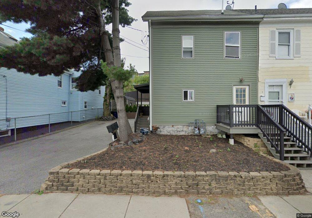
8 Chester Ave Somerville, MA 02143
East Somerville NeighborhoodEstimated Value: $1,027,258 - $1,315,000
4
Beds
1
Bath
1,704
Sq Ft
$672/Sq Ft
Est. Value
About This Home
This home is located at 8 Chester Ave, Somerville, MA 02143 and is currently estimated at $1,144,315, approximately $671 per square foot. 8 Chester Ave is a home located in Middlesex County with nearby schools including Somerville High School, Mystic Valley Regional Charter School, and Prospect Hill Academy Upper Elementary Campus.
Ownership History
Date
Name
Owned For
Owner Type
Purchase Details
Closed on
Jun 5, 2003
Sold by
Kuhn Paul E Est
Bought by
Rego Daniel
Current Estimated Value
Home Financials for this Owner
Home Financials are based on the most recent Mortgage that was taken out on this home.
Original Mortgage
$225,000
Outstanding Balance
$98,918
Interest Rate
5.83%
Mortgage Type
Purchase Money Mortgage
Estimated Equity
$1,045,397
Create a Home Valuation Report for This Property
The Home Valuation Report is an in-depth analysis detailing your home's value as well as a comparison with similar homes in the area
Home Values in the Area
Average Home Value in this Area
Purchase History
| Date | Buyer | Sale Price | Title Company |
|---|---|---|---|
| Rego Daniel | $250,000 | -- |
Source: Public Records
Mortgage History
| Date | Status | Borrower | Loan Amount |
|---|---|---|---|
| Open | Rego Daniel | $225,000 |
Source: Public Records
Tax History Compared to Growth
Tax History
| Year | Tax Paid | Tax Assessment Tax Assessment Total Assessment is a certain percentage of the fair market value that is determined by local assessors to be the total taxable value of land and additions on the property. | Land | Improvement |
|---|---|---|---|---|
| 2025 | $9,360 | $857,900 | $407,800 | $450,100 |
| 2024 | $8,755 | $832,200 | $407,800 | $424,400 |
| 2023 | $8,722 | $843,500 | $407,800 | $435,700 |
| 2022 | $8,154 | $801,000 | $388,400 | $412,600 |
| 2021 | $7,794 | $764,900 | $383,000 | $381,900 |
| 2020 | $7,357 | $729,100 | $368,300 | $360,800 |
| 2019 | $6,861 | $637,600 | $305,600 | $332,000 |
| 2018 | $6,200 | $548,200 | $244,300 | $303,900 |
| 2017 | $5,946 | $509,500 | $230,500 | $279,000 |
| 2016 | $5,394 | $430,500 | $161,900 | $268,600 |
| 2015 | $5,392 | $427,600 | $161,100 | $266,500 |
Source: Public Records
Map
Nearby Homes
- 142 Cross St
- 20 Alston St
- 25 Auburn Ave Unit 2
- 25 Alston St
- 39 Gilman St
- 36 Fountain Ave
- 74 Gilman St Unit 1
- 34 Knowlton St Unit 2
- 85 A Munroe St Unit 1
- 84 Cross St
- 147 - 149 Pearl
- 28 Highland Ave Unit 3
- 192 Washington St Unit C
- 76 Franklin St
- 36 Everett Ave
- 30 Walnut St
- 19 Everett Ave
- 38 Franklin Ave
- 18 Otis St
- 14 Bonair St Unit 14
- 9 Chester Ave
- 7 Chester Ave
- 455 Mcgrath Hwy
- 6 Chester Ave
- 5 Chester Ave
- 450 Mcgrath Hwy Unit 413
- 450 Mcgrath Hwy Unit 206
- 450 Mcgrath Hwy
- 438 Mcgrath Hwy Unit 314T
- 438 Mcgrath Hwy Unit 314A
- 438 Mcgrath Hwy Unit 201A
- 438 Mcgrath Hwy Unit 304
- 3 Chester Ave
- 436 Mcgrath Hwy Unit 316
- 436 Mcgrath Hwy Unit 305
- 436 Mcgrath Hwy Unit 203
- 432 Mcgrath Hwy Unit 434-409
- 432 Mcgrath Hwy Unit 434-411 copy
- 432 Mcgrath Hwy Unit 434-413
- 432 Mcgrath Hwy Unit 202