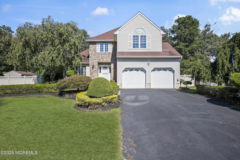
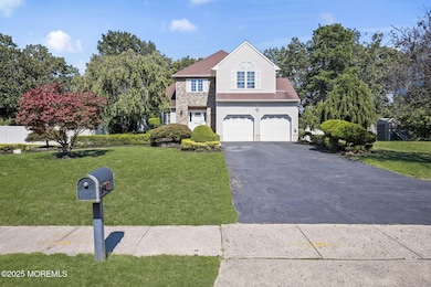
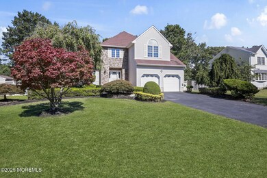
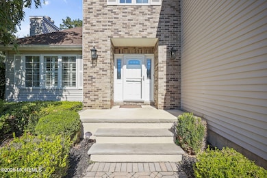
8 Coral Dr Howell, NJ 07731
Land of Pines NeighborhoodEstimated payment $5,733/month
Highlights
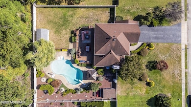
- In Ground Pool
- New Kitchen
- Backs to Trees or Woods
- Howell High School Rated A-
- Colonial Architecture
- Wood Flooring
About This Home
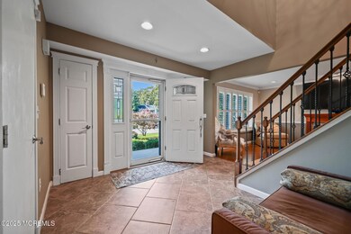
AMAZING OPPORTUNITY TO OWN THIS CENTER HALL COLONIAL WITH RESORT BACKYARD!! This home has been lovingly updated by the original owners throughout the years. Landscape has been meticulously groomed and easy to maintain throughout the property. Remodeled Eat-in Kitchen w gas cooktop, new SS refrigerator and breakfast nook with storage benches. All 3 bathrooms have been remodeled and basement recently finished. Fully boarded attic for more interior storage. Home also comes with 2 storage sheds. Fully gated backyard allows for so much play -in ground pool with diving board, plenty of space poolside for lounging, large lawn as well as oversized wooded deck for BBQs and dining al fresco. If you have been waiting for THE ONE... this is it! Come see this home in person!
Listing Agent
Realty One Group Central Brokerage Phone: 732.547.3984 License #1329190 Listed on: 10/03/2025

Home Details
Home Type
- Single Family
Est. Annual Taxes
- $11,932
Year Built
- Built in 1998
Lot Details
- 0.36 Acre Lot
- Fenced
- Sprinkler System
- Backs to Trees or Woods
Parking
- 2 Car Attached Garage
- Garage Door Opener
- Double-Wide Driveway
Home Design
- Colonial Architecture
- Shingle Roof
- Aluminum Siding
Interior Spaces
- 1,879 Sq Ft Home
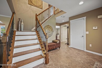
- 3-Story Property
- Crown Molding
- Ceiling Fan
- Recessed Lighting
- Track Lighting
- Light Fixtures
- Gas Fireplace
- Blinds
- Bay Window
- Window Screens
- Sliding Doors
- Entrance Foyer
- Family Room
- Living Room
- Dining Room
- Center Hall
- Basement Fills Entire Space Under The House
- Home Security System
- Attic
Kitchen
- New Kitchen
- Breakfast Area or Nook
- Eat-In Kitchen
- Self-Cleaning Oven
- Gas Cooktop
- Stove
- Portable Range
- Range Hood
- Microwave
- Dishwasher
- Granite Countertops
Flooring
- Wood
- Ceramic Tile
Bedrooms and Bathrooms
- 3 Bedrooms
- Walk-In Closet
- Primary Bathroom is a Full Bathroom
- Dual Vanity Sinks in Primary Bathroom
- Primary Bathroom includes a Walk-In Shower
Laundry
- Laundry Room
- Dryer
- Washer
Pool
- In Ground Pool
- Fence Around Pool
Outdoor Features
- Exterior Lighting
- Gazebo
- Shed
- Storage Shed
Schools
- Land O Pines Elementary School
- Howell Middle School
- Freehold Twp High School
Utilities
- Forced Air Heating and Cooling System
- Natural Gas Water Heater
Community Details
- No Home Owners Association
- Briar Knoll Subdivision
Listing and Financial Details
- Assessor Parcel Number 21-00059-0000-00004-04
Map
Home Values in the Area
Average Home Value in this Area
Tax History
| Year | Tax Paid | Tax Assessment Tax Assessment Total Assessment is a certain percentage of the fair market value that is determined by local assessors to be the total taxable value of land and additions on the property. | Land | Improvement |
|---|---|---|---|---|
| 2025 | $11,932 | $681,600 | $361,000 | $320,600 |
| 2024 | $11,773 | $672,200 | $333,000 | $339,200 |
| 2023 | $11,773 | $632,300 | $301,000 | $331,300 |
| 2022 | $10,135 | $476,400 | $161,000 | $315,400 |
| 2021 | $10,135 | $441,600 | $161,000 | $280,600 |
| 2020 | $10,579 | $455,000 | $161,000 | $294,000 |
| 2019 | $10,665 | $450,000 | $161,000 | $289,000 |
| 2018 | $10,469 | $439,700 | $161,000 | $278,700 |
| 2017 | $10,532 | $437,200 | $161,000 | $276,200 |
| 2016 | $10,181 | $417,100 | $161,000 | $256,100 |
| 2015 | $9,818 | $398,300 | $146,000 | $252,300 |
| 2014 | $9,451 | $338,400 | $146,000 | $192,400 |
Property History
| Date | Event | Price | List to Sale | Price per Sq Ft |
|---|---|---|---|---|
| 10/03/2025 10/03/25 | For Sale | $899,000 | -- | $478 / Sq Ft |
Purchase History
| Date | Type | Sale Price | Title Company |
|---|---|---|---|
| Deed | $186,300 | -- |
Mortgage History
| Date | Status | Loan Amount | Loan Type |
|---|---|---|---|
| Closed | $155,000 | No Value Available |
Source: MOREMLS (Monmouth Ocean Regional REALTORS®)
MLS Number: 22530068
APN: 21-00059-0000-00004-04
Disclaimer: Certain information contained herein is derived from information provided by parties other than Homes.com. All information provided is deemed reliable, but is not guaranteed to be accurate and should be independently verified.
![]() IDX information is provided exclusively for personal, non-commercial use, and may not be used for any purpose other than to identify prospective properties consumers may be interested in purchasing.
IDX information is provided exclusively for personal, non-commercial use, and may not be used for any purpose other than to identify prospective properties consumers may be interested in purchasing.
Information is deemed reliable but not guaranteed.
- 4 Coral Dr
- 6 Coral Dr
- 409 Aldrich Rd
- 15 Windsor Rd
- 27 Poppy Ln
- 16 Maple Ln
- 15 N Longview Rd
- 2390 U S Highway 9
- 17 N Longview Rd
- 20 N Longview Rd
- 324 Aldrich Rd
- 28 Salem Hill Rd
- 105 S Durham Dr
- 107 S Durham Dr
- 53 Hilltop Rd
- 0 Route 9
- 4 Christopher Dr
- 24 Friendship Rd
- 21 Christopher Dr
- 19 Kensington Dr
- 16 Burdge Dr
- 10 Oakwood Dr
- 30 Brunswick Dr
- 24 Friendship Rd
- 203 Sunset Ln
- 6 Cattail Dr
- 16 Peachstone Rd
- 16 Spicy Pond Rd
- 1045 Farmingdale Rd
- 15 N American Dr
- 1020 Larsen Rd
- 6461 Us Highway 9 Unit 445
- 6461 Us Highway 9 Unit 135
- 6461 Us Highway 9 Unit 433
- 6461 Us Highway 9 Unit 111
- 6461 Rte 9 North Us 9 Unit 4 O
- 6461 Rte 9 North Us 9 Unit 3 G
- 6461 Rte 9 Unit 112
- 6461 U S 9
- 6461 U S 9 Unit 442