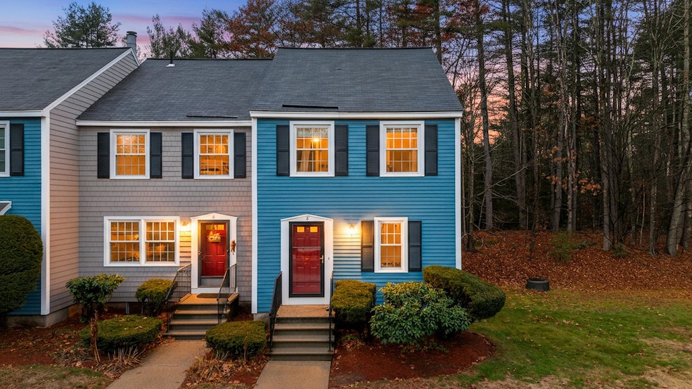
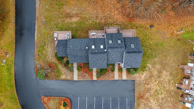
8 Donovan Ct MerriMacK, NH 03054
Estimated payment $2,424/month
Highlights
- Deck
- Skylights
- Landscaped
- Reeds Ferry School Rated 9+
- Natural Light
- Vinyl Plank Flooring
About This Home
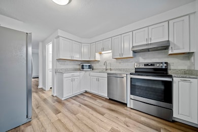
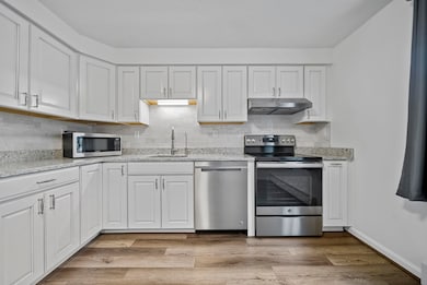
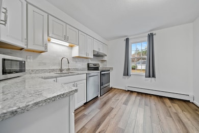
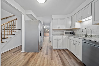
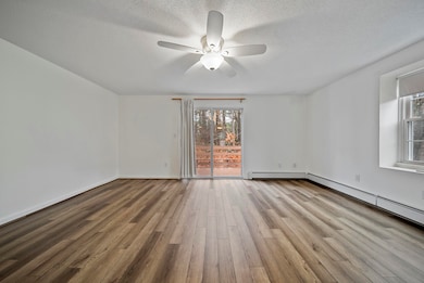
Open House Sun 11/16 11-1PM! ALL the comforts of a low maintenance lifestyle in this SPACIOUS + METICULOUSLY MAINTAINED 4 Level Townhome, PET FRIENDLY, & VA Approved. Offering 2+1 Bedrooms (Finished Private Loft), You’ll enter the main level where you’ll find a beautifully appointed kitchen with fresh white cabinets, QUARTZ COUNTER TOPS, newer stainless steel appliances, pantry & reverse osmosis water filter. The inviting living room walks out to the inviting and spacious deck. An updated half bath & coat closet complete the first level. Upstairs you’ll find two spacious bedrooms, a recently upgraded full bath with a Koehler LuxStone shower. Walk up to the third level and find the light + bright private loft complete with its own closet and skylight, making it a perfect THIRD BEDROOM or home office. The WALK OUT LOWER LEVEL is ready to be finished into another living area or additional bedrooms, offering a laundry area, ample storage space & endless possibilities. Notable Updates Include: Reverse Osmosis Water Filter (2025), Luxstone Shower (2024), Luxury Vinyl Flooring Throughout (2022), New Kitchen (2020), Water Heater (2020), GFCI Receptables (2020), Pella Front Door, Frame, Storm Door (2019) & so much more! Schedule your tour today, this is one you dont want to miss!
Townhouse Details
Home Type
- Townhome
Est. Annual Taxes
- $5,640
Year Built
- Built in 1985
Home Design
- Concrete Foundation
- Vinyl Siding
Interior Spaces
- Property has 3.5 Levels
- Ceiling Fan
- Skylights
- Natural Light
- Vinyl Plank Flooring
- Walk-Out Basement
Kitchen
- Microwave
- Dishwasher
Bedrooms and Bathrooms
- 3 Bedrooms
Laundry
- Dryer
- Washer
Home Security
Parking
- Paved Parking
- Assigned Parking
Schools
- Merrimack Middle School
- Merrimack High School
Utilities
- Hot Water Heating System
- Cable TV Available
Additional Features
- Deck
- Landscaped
Community Details
Recreation
- Snow Removal
Additional Features
- Woodbury II Condos
- Common Area
- Fire and Smoke Detector
Map
Home Values in the Area
Average Home Value in this Area
Tax History
| Year | Tax Paid | Tax Assessment Tax Assessment Total Assessment is a certain percentage of the fair market value that is determined by local assessors to be the total taxable value of land and additions on the property. | Land | Improvement |
|---|---|---|---|---|
| 2024 | $5,278 | $255,100 | $0 | $255,100 |
| 2023 | $4,962 | $255,100 | $0 | $255,100 |
| 2022 | $4,434 | $255,100 | $0 | $255,100 |
| 2021 | $4,380 | $255,100 | $0 | $255,100 |
| 2020 | $3,881 | $161,300 | $0 | $161,300 |
| 2019 | $3,892 | $161,300 | $0 | $161,300 |
| 2018 | $3,891 | $161,300 | $0 | $161,300 |
| 2017 | $3,739 | $160,000 | $0 | $160,000 |
| 2016 | $3,646 | $160,000 | $0 | $160,000 |
| 2015 | $3,891 | $157,400 | $0 | $157,400 |
| 2014 | $3,792 | $157,400 | $0 | $157,400 |
| 2013 | $4,003 | $167,400 | $0 | $167,400 |
Property History
| Date | Event | Price | List to Sale | Price per Sq Ft |
|---|---|---|---|---|
| 11/14/2025 11/14/25 | For Sale | $370,000 | -- | $257 / Sq Ft |
Purchase History
| Date | Type | Sale Price | Title Company |
|---|---|---|---|
| Quit Claim Deed | -- | None Available | |
| Warranty Deed | $108,500 | -- |
Mortgage History
| Date | Status | Loan Amount | Loan Type |
|---|---|---|---|
| Previous Owner | $80,000 | Unknown | |
| Previous Owner | $100,000 | Unknown | |
| Previous Owner | $106,050 | No Value Available |
Source: PrimeMLS
MLS Number: 5069646
APN: MRMK-000006C-000349-000104
Disclaimer: Certain information contained herein is derived from information provided by parties other than Homes.com. All information provided is deemed reliable, but is not guaranteed to be accurate and should be independently verified.
![]() Copyright 2025 PrimeMLS, Inc. All rights reserved. This information is deemed reliable, but not guaranteed. The data relating to real estate displayed on this display comes in part from the IDX Program of PrimeMLS. The information being provided is for consumers’ personal, non-commercial use and may not be used for any purpose other than to identify prospective properties consumers may be interested in purchasing.
Copyright 2025 PrimeMLS, Inc. All rights reserved. This information is deemed reliable, but not guaranteed. The data relating to real estate displayed on this display comes in part from the IDX Program of PrimeMLS. The information being provided is for consumers’ personal, non-commercial use and may not be used for any purpose other than to identify prospective properties consumers may be interested in purchasing.
- 185 Indian Rock Rd
- 4 Twin Bridge Rd
- 17 Powderhouse Rd
- 10 Center St
- 19A Loop Rd
- 3 Gilbert Dr
- 360 Daniel Webster Hwy
- 3 Maple Ridge Dr Unit 221
- 540 Charles Bancroft Hwy Unit 4Belg
- 1 Vanderbilt Dr
- 2 Executive Park Dr
- 6 Dutch Dr
- 246 Daniel Webster Hwy
- 15 Iron Horse Dr
- 19 Mason Rd
- 49 Technology Dr
- 3 Lexington Ct
- 2 Bow Ln
- 334 S River Rd
- 216 County Rd
