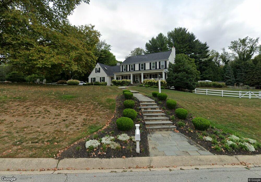
8 Duncan Ln Bryn Mawr, PA 19010
Estimated Value: $1,200,000 - $1,821,000
4
Beds
3
Baths
3,260
Sq Ft
$441/Sq Ft
Est. Value
About This Home
This home is located at 8 Duncan Ln, Bryn Mawr, PA 19010 and is currently estimated at $1,438,284, approximately $441 per square foot. 8 Duncan Ln is a home located in Delaware County with nearby schools including Ithan Elementary School, Radnor Middle School, and Radnor Senior High School.
Ownership History
Date
Name
Owned For
Owner Type
Purchase Details
Closed on
Mar 30, 2005
Sold by
Devine Richard E and Devine Kimberly
Bought by
Ryan James and Ryan Leslie
Current Estimated Value
Home Financials for this Owner
Home Financials are based on the most recent Mortgage that was taken out on this home.
Original Mortgage
$804,000
Outstanding Balance
$454,992
Interest Rate
7.3%
Mortgage Type
Purchase Money Mortgage
Estimated Equity
$983,292
Purchase Details
Closed on
Jul 30, 1998
Sold by
Fierce Steven W and Fierce Barbara J
Bought by
Devine Richard E
Home Financials for this Owner
Home Financials are based on the most recent Mortgage that was taken out on this home.
Original Mortgage
$227,000
Interest Rate
6.92%
Mortgage Type
Purchase Money Mortgage
Create a Home Valuation Report for This Property
The Home Valuation Report is an in-depth analysis detailing your home's value as well as a comparison with similar homes in the area
Home Values in the Area
Average Home Value in this Area
Purchase History
| Date | Buyer | Sale Price | Title Company |
|---|---|---|---|
| Ryan James | $1,005,000 | -- | |
| Devine Richard E | $517,500 | Commonwealth Land Title Ins |
Source: Public Records
Mortgage History
| Date | Status | Borrower | Loan Amount |
|---|---|---|---|
| Open | Ryan James | $804,000 | |
| Previous Owner | Devine Richard E | $227,000 |
Source: Public Records
Tax History Compared to Growth
Tax History
| Year | Tax Paid | Tax Assessment Tax Assessment Total Assessment is a certain percentage of the fair market value that is determined by local assessors to be the total taxable value of land and additions on the property. | Land | Improvement |
|---|---|---|---|---|
| 2025 | $15,659 | $774,490 | $231,060 | $543,430 |
| 2024 | $15,659 | $774,490 | $231,060 | $543,430 |
| 2023 | $15,198 | $774,490 | $231,060 | $543,430 |
| 2022 | $14,874 | $774,490 | $231,060 | $543,430 |
| 2021 | $23,892 | $774,490 | $231,060 | $543,430 |
| 2020 | $15,973 | $459,170 | $161,000 | $298,170 |
| 2019 | $15,523 | $459,170 | $161,000 | $298,170 |
| 2018 | $15,218 | $459,170 | $0 | $0 |
| 2017 | $14,900 | $459,170 | $0 | $0 |
| 2016 | $2,571 | $459,170 | $0 | $0 |
| 2015 | $2,571 | $459,170 | $0 | $0 |
| 2014 | $2,571 | $459,170 | $0 | $0 |
Source: Public Records
Map
Nearby Homes
- 14 Westview Rd
- 53 Parkridge Dr
- 62 Parkridge Dr Unit 62
- 67 Parkridge Dr
- 307 B B000 Summit Dr Unit B
- 202 Summit Dr Unit B
- 103 Summit Dr Unit B
- 390 S Bryn Mawr Ave
- 145 Landover Rd
- 633 Foxfields Rd
- 215 Cornell Dr
- 173 Clemson Rd
- 258 Lee Cir
- 741 County Line Rd
- 6205 Parkview Dr
- 560 S Bryn Mawr Ave
- 75 S Merion Ave
- 50 Prospect Ave
- 133 Quaker Ln
- 732 Buck Ln