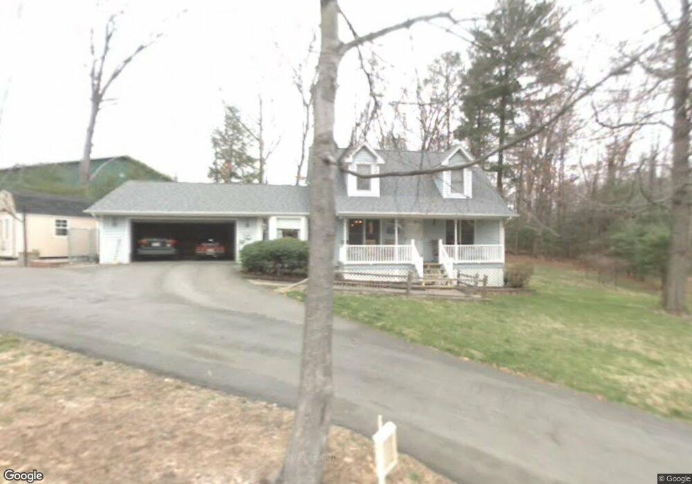
8 Josh Dr Fletcher, NC 28732
Estimated Value: $430,000 - $508,000
3
Beds
2
Baths
2,029
Sq Ft
$224/Sq Ft
Est. Value
About This Home
This home is located at 8 Josh Dr, Fletcher, NC 28732 and is currently estimated at $455,307, approximately $224 per square foot. 8 Josh Dr is a home located in Henderson County with nearby schools including Glenn C. Marlow Elementary School, Rugby Middle School, and West Henderson High School.
Ownership History
Date
Name
Owned For
Owner Type
Purchase Details
Closed on
Oct 12, 2018
Sold by
Bowen Gary B
Bought by
Bowen Jennifer B and Bowen Gary Ryan
Current Estimated Value
Home Financials for this Owner
Home Financials are based on the most recent Mortgage that was taken out on this home.
Original Mortgage
$222,000
Outstanding Balance
$195,100
Interest Rate
4.87%
Mortgage Type
New Conventional
Estimated Equity
$260,207
Create a Home Valuation Report for This Property
The Home Valuation Report is an in-depth analysis detailing your home's value as well as a comparison with similar homes in the area
Home Values in the Area
Average Home Value in this Area
Purchase History
| Date | Buyer | Sale Price | Title Company |
|---|---|---|---|
| Bowen Jennifer B | $220,000 | -- |
Source: Public Records
Mortgage History
| Date | Status | Borrower | Loan Amount |
|---|---|---|---|
| Open | Bowen Jennifer B | $222,000 |
Source: Public Records
Tax History
| Year | Tax Paid | Tax Assessment Tax Assessment Total Assessment is a certain percentage of the fair market value that is determined by local assessors to be the total taxable value of land and additions on the property. | Land | Improvement |
|---|---|---|---|---|
| 2025 | $1,704 | $395,400 | $94,200 | $301,200 |
| 2024 | $17 | $395,400 | $94,200 | $301,200 |
| 2023 | $1,704 | $395,400 | $94,200 | $301,200 |
| 2022 | $1,381 | $246,100 | $48,500 | $197,600 |
| 2021 | $1,381 | $246,100 | $48,500 | $197,600 |
| 2020 | $1,381 | $246,100 | $0 | $0 |
| 2019 | $1,381 | $246,100 | $0 | $0 |
| 2018 | $1,216 | $215,300 | $0 | $0 |
| 2017 | $1,216 | $215,300 | $0 | $0 |
| 2016 | $1,216 | $215,300 | $0 | $0 |
| 2015 | -- | $215,300 | $0 | $0 |
| 2014 | -- | $207,700 | $0 | $0 |
Source: Public Records
Map
Nearby Homes
- 92 Wiltshire Cir
- 88 Wiltshire Cir
- 48 Lanceford Cir
- 155 Wiltshire Cir
- 165 Wiltshire Cir
- 50 Farington Cir
- 93 Stafford Ct
- 49 Farington Cir
- 429 Wiltshire Cir
- 412 Wiltshire Cir
- 196 Underwood Rd
- 550 Airport Rd
- 66 Orwell Dr
- 106 N Christie Ct
- 52 N Christie Ct
- 613 Carolina Holly Way
- 25 Norman Rd
- 242 Windsor Forest Cir
- 911 Fanning Bridge Rd
- 15 Golden Oaks Ln
- 6 W Rutledge Ct
- 5 Josh Dr
- 10 W Rutledge Ct
- 2 W Rutledge Ct
- 5 W Rutledge Ct
- 235 Rutledge Rd
- 9 W Rutledge Ct
- 15 Lance Ln
- 1 W Rutledge Ct
- 220 Rutledge Rd
- 231 Rutledge Rd
- 19 Lance Ln
- 3 Brandy Ln
- 11 Lance Ln
- 4 Brandy Ln
- 75 Litchfield Place
- 215 Rutledge Rd
- 65 Litchfield Place
- 104 Wiltshire Cir
- 92 Wiltshire Cir Unit 19
Your Personal Tour Guide
Ask me questions while you tour the home.