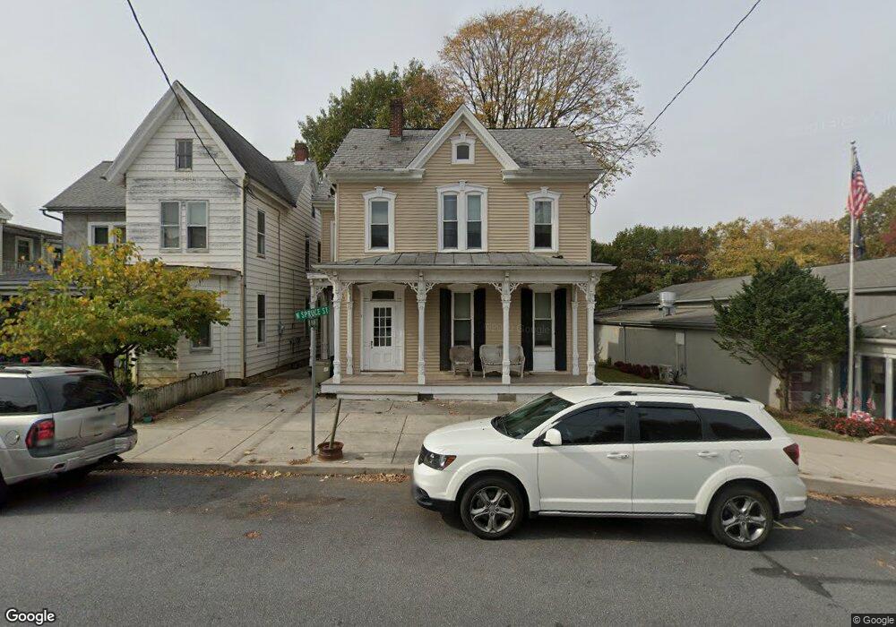
8 N Spruce St Lititz, PA 17543
Estimated Value: $361,000 - $424,000
Studio
3
Baths
2,546
Sq Ft
$158/Sq Ft
Est. Value
About This Home
This home is located at 8 N Spruce St, Lititz, PA 17543 and is currently estimated at $402,323, approximately $158 per square foot. 8 N Spruce St is a home located in Lancaster County with nearby schools including Warwick Senior High School, Lititz Christian School, and Linden Hall.
Ownership History
Date
Name
Owned For
Owner Type
Purchase Details
Closed on
Mar 31, 2023
Sold by
Brickerville Management Lp
Bought by
Bkz Legacy Llc
Current Estimated Value
Home Financials for this Owner
Home Financials are based on the most recent Mortgage that was taken out on this home.
Original Mortgage
$307,000
Outstanding Balance
$298,021
Interest Rate
6.32%
Mortgage Type
New Conventional
Estimated Equity
$104,302
Purchase Details
Closed on
Mar 26, 2008
Sold by
Kase Shawn M
Bought by
Wachovia Mortgage Corp
Purchase Details
Closed on
Nov 22, 2005
Sold by
Landis Gary R and Landis Brenda J
Bought by
Kase Shawn M
Home Financials for this Owner
Home Financials are based on the most recent Mortgage that was taken out on this home.
Original Mortgage
$209,000
Interest Rate
6.06%
Mortgage Type
Fannie Mae Freddie Mac
Create a Home Valuation Report for This Property
The Home Valuation Report is an in-depth analysis detailing your home's value as well as a comparison with similar homes in the area
Home Values in the Area
Average Home Value in this Area
Purchase History
| Date | Buyer | Sale Price | Title Company |
|---|---|---|---|
| Bkz Legacy Llc | $300,000 | Homesale Settlement Services | |
| Wachovia Mortgage Corp | $5,745 | None Available | |
| Kase Shawn M | $220,000 | First American Title Ins Co |
Source: Public Records
Mortgage History
| Date | Status | Borrower | Loan Amount |
|---|---|---|---|
| Open | Bkz Legacy Llc | $307,000 | |
| Previous Owner | Kase Shawn M | $209,000 |
Source: Public Records
Tax History
| Year | Tax Paid | Tax Assessment Tax Assessment Total Assessment is a certain percentage of the fair market value that is determined by local assessors to be the total taxable value of land and additions on the property. | Land | Improvement |
|---|---|---|---|---|
| 2025 | $5,085 | $224,800 | $54,400 | $170,400 |
| 2024 | $5,085 | $224,800 | $54,400 | $170,400 |
| 2023 | $5,065 | $224,800 | $54,400 | $170,400 |
| 2022 | $4,784 | $224,800 | $54,400 | $170,400 |
| 2021 | $4,784 | $224,800 | $54,400 | $170,400 |
| 2020 | $4,784 | $224,800 | $54,400 | $170,400 |
| 2019 | $4,784 | $224,800 | $54,400 | $170,400 |
| 2018 | $3,680 | $224,800 | $54,400 | $170,400 |
| 2017 | $3,865 | $142,700 | $37,100 | $105,600 |
| 2016 | $3,865 | $142,700 | $37,100 | $105,600 |
| 2015 | $904 | $142,700 | $37,100 | $105,600 |
| 2014 | $2,813 | $142,700 | $37,100 | $105,600 |
Source: Public Records
Map
Nearby Homes
- LOT 14 Thaton Rd
- LOT 12 Thaton Rd
- 133 S Spruce St
- 24 E Orange St
- 147 S Spruce St
- 16 E Market St
- 3 Amberly Way
- 146 N Cedar St
- 141 E Lincoln Ave
- 504 Hensley St
- 320 N New St
- 1500 Furnace Hills Pike
- 601 E Main St
- 146 S Oak St
- 514 Woodcrest Ave
- 213 N Locust St
- 501 E New St
- 117 Laurie Ln
- 588 Crosswinds Dr
- 138 Moorland Ct
Your Personal Tour Guide
Ask me questions while you tour the home.