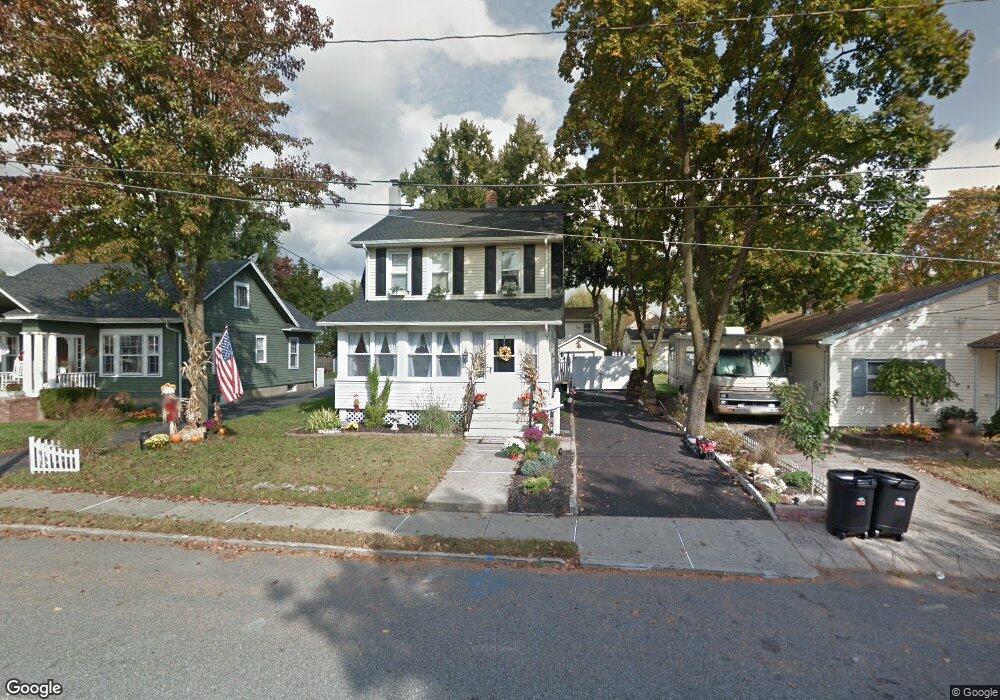
8 Orchard St Bloomingdale, NJ 07403
Estimated Value: $491,000 - $521,798
--
Bed
--
Bath
1,441
Sq Ft
$354/Sq Ft
Est. Value
About This Home
This home is located at 8 Orchard St, Bloomingdale, NJ 07403 and is currently estimated at $509,700, approximately $353 per square foot. 8 Orchard St is a home located in Passaic County with nearby schools including Samuel R. Donald School, Martha B. Day School, and Walter T. Bergen Middle School.
Ownership History
Date
Name
Owned For
Owner Type
Purchase Details
Closed on
Dec 7, 2021
Sold by
Tedone and Elisabeth
Bought by
Qosaj Ragip and Qosaj Aferdita
Current Estimated Value
Purchase Details
Closed on
Feb 18, 2009
Sold by
Tedone Robert and Tedone Tina L
Bought by
Tedone Robert
Purchase Details
Closed on
Aug 25, 2003
Sold by
War Matthew
Bought by
Tedone Robert and Tedone Tina
Home Financials for this Owner
Home Financials are based on the most recent Mortgage that was taken out on this home.
Original Mortgage
$284,900
Interest Rate
6.02%
Purchase Details
Closed on
Oct 26, 1994
Sold by
Cupelli Steve
Bought by
War Matthew and War Heather
Home Financials for this Owner
Home Financials are based on the most recent Mortgage that was taken out on this home.
Original Mortgage
$125,000
Interest Rate
8.91%
Create a Home Valuation Report for This Property
The Home Valuation Report is an in-depth analysis detailing your home's value as well as a comparison with similar homes in the area
Home Values in the Area
Average Home Value in this Area
Purchase History
| Date | Buyer | Sale Price | Title Company |
|---|---|---|---|
| Qosaj Ragip | $405,000 | Stewart Title | |
| Qosaj Ragip | $405,000 | Stewart Title | |
| Tedone Robert | -- | -- | |
| Tedone Robert | $319,900 | -- | |
| War Matthew | $157,000 | -- |
Source: Public Records
Mortgage History
| Date | Status | Borrower | Loan Amount |
|---|---|---|---|
| Previous Owner | Tedone Robert | $284,900 | |
| Previous Owner | War Matthew | $125,000 |
Source: Public Records
Tax History Compared to Growth
Tax History
| Year | Tax Paid | Tax Assessment Tax Assessment Total Assessment is a certain percentage of the fair market value that is determined by local assessors to be the total taxable value of land and additions on the property. | Land | Improvement |
|---|---|---|---|---|
| 2025 | $10,660 | $232,400 | $103,600 | $128,800 |
| 2024 | $10,463 | $232,400 | $103,600 | $128,800 |
| 2022 | $10,446 | $232,400 | $103,600 | $128,800 |
| 2021 | $10,221 | $232,400 | $103,600 | $128,800 |
| 2020 | $10,137 | $232,400 | $103,600 | $128,800 |
| 2019 | $10,035 | $232,400 | $103,600 | $128,800 |
| 2018 | $9,982 | $232,400 | $103,600 | $128,800 |
| 2017 | $9,793 | $232,400 | $103,600 | $128,800 |
| 2016 | $9,656 | $232,400 | $103,600 | $128,800 |
| 2015 | $9,422 | $232,400 | $103,600 | $128,800 |
| 2014 | $9,075 | $232,400 | $103,600 | $128,800 |
Source: Public Records
Map
Nearby Homes
- 20 Orchard St
- 31 Hamilton St
- 22 Chestnut St
- 81 Mountain View Ct Unit 81
- 81 Mountainview Ct
- 29 Leary Ave
- 17 Walnut St
- 60 Rockcreek Terrace Unit 60
- 76 Reeve Ave
- 19 Pearl St
- 32 Matthews Terrace
- 7201 Coventry Ct Unit 201
- 7110 Coventry Ct
- 7409 Coventry Ct Unit 7409
- 7217 Coventry Ct
- 89 Knolls Rd
- 1 Ogden Terrace
- 1410 Wharton Ct