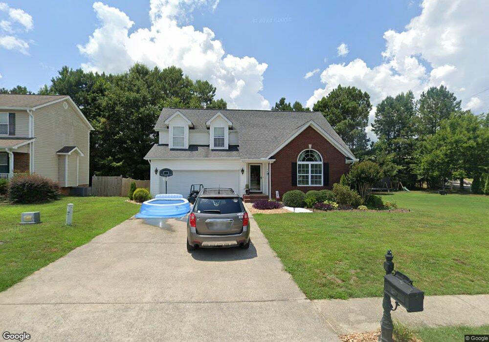
8 Quail Run Unit LOT 48 La Fayette, GA 30728
Estimated Value: $271,000 - $316,000
4
Beds
3
Baths
1,808
Sq Ft
$163/Sq Ft
Est. Value
About This Home
This home is located at 8 Quail Run Unit LOT 48, La Fayette, GA 30728 and is currently estimated at $294,215, approximately $162 per square foot. 8 Quail Run Unit LOT 48 is a home located in Walker County with nearby schools including North Lafayette Elementary School, Lafayette Middle School, and Lafayette High School.
Ownership History
Date
Name
Owned For
Owner Type
Purchase Details
Closed on
Jun 30, 2011
Sold by
David Maples Construction Co Inc
Bought by
Whitten Christina M
Current Estimated Value
Home Financials for this Owner
Home Financials are based on the most recent Mortgage that was taken out on this home.
Original Mortgage
$111,200
Outstanding Balance
$76,719
Interest Rate
4.57%
Mortgage Type
New Conventional
Estimated Equity
$217,496
Purchase Details
Closed on
Oct 10, 2005
Sold by
Not Provided
Bought by
Whitten Christina M
Purchase Details
Closed on
Sep 26, 2003
Bought by
Walker Land Investments Llc
Create a Home Valuation Report for This Property
The Home Valuation Report is an in-depth analysis detailing your home's value as well as a comparison with similar homes in the area
Home Values in the Area
Average Home Value in this Area
Purchase History
| Date | Buyer | Sale Price | Title Company |
|---|---|---|---|
| Whitten Christina M | $139,000 | -- | |
| Whitten Christina M | $25,000 | -- | |
| Walker Land Investments Llc | $222,900 | -- |
Source: Public Records
Mortgage History
| Date | Status | Borrower | Loan Amount |
|---|---|---|---|
| Open | Whitten Christina M | $111,200 |
Source: Public Records
Tax History Compared to Growth
Tax History
| Year | Tax Paid | Tax Assessment Tax Assessment Total Assessment is a certain percentage of the fair market value that is determined by local assessors to be the total taxable value of land and additions on the property. | Land | Improvement |
|---|---|---|---|---|
| 2024 | $2,476 | $103,954 | $6,000 | $97,954 |
| 2023 | $2,429 | $98,956 | $6,000 | $92,956 |
| 2022 | $2,269 | $86,172 | $6,000 | $80,172 |
| 2021 | $2,069 | $70,464 | $6,000 | $64,464 |
| 2020 | $1,848 | $60,242 | $6,000 | $54,242 |
| 2019 | $1,849 | $60,242 | $6,000 | $54,242 |
| 2018 | $1,792 | $60,242 | $6,000 | $54,242 |
| 2017 | $1,822 | $54,776 | $6,000 | $48,776 |
| 2016 | $1,510 | $54,776 | $6,000 | $48,776 |
| 2015 | $1,729 | $59,742 | $10,000 | $49,742 |
| 2014 | $1,664 | $59,742 | $10,000 | $49,742 |
| 2013 | -- | $59,742 | $10,000 | $49,742 |
Source: Public Records
Map
Nearby Homes
- 111 Dove Dr
- 114 Mallard Ln
- 105 Stanfield Rd
- 214 East Ave
- 1403 N Main St
- 1520 N Main St
- 1001 N Main St
- 393 Wisteria Rd
- 71 McCarter Rd
- 1118 Probasco St N
- 1314 Fernwood Dr
- 7552 Us Highway 27
- 1303 Campbell Crescent
- 79 Hobart Ln
- 1309 Campbell Crescent
- 4941 Round Pond Rd
- 0 Center St Unit 1517720
- 307 Park St
- 205 N Ridge Dr
- 307 Ridgecrest Dr