8 Quorn Hunt Rd West Simsbury, CT 06092
Estimated payment $3,153/month
Highlights
- Colonial Architecture
- Attic
- Exterior Wheelchair Lift
- Tootin' Hills School Rated A
- 1 Fireplace
- Shed
About This Home
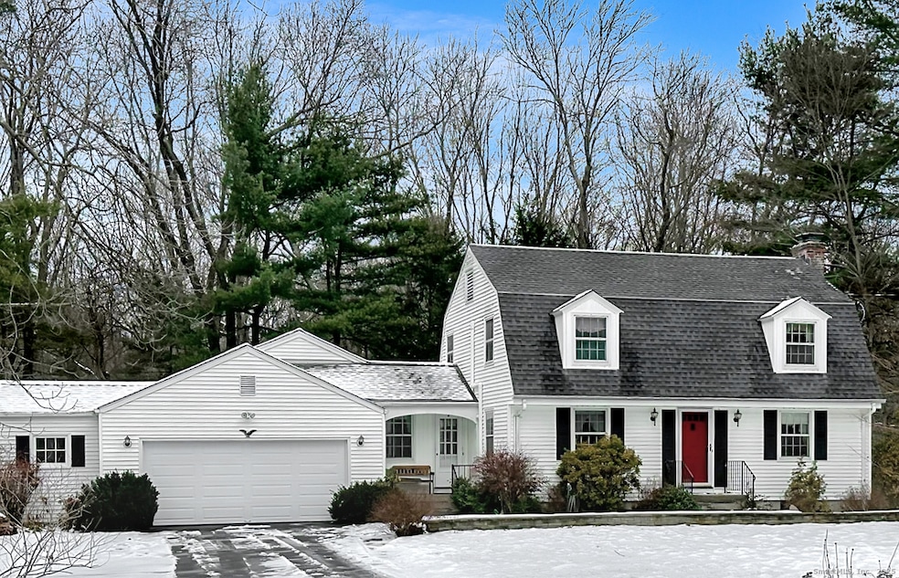
Welcome home to this charming Gambrel Colonial located in a desirable West Simsbury neighborhood. This 3-bedroom home offers a flexible floor plan featuring a kitchen, living room with fireplace, family room, dining room, and convenient first-floor laundry. The second level includes three bedrooms with hardwood floors and a full bath. The finished walkout lower level provides wonderful versatility-perfect for a possible in-law space with a full bath, a home office, or a recreation/playroom. Additional features include mini-split AC units, two sheds, and a private backyard. Ideally located just minutes from the local elementary school, with easy access to hiking trails, local farms, the Rails-to-Trails bike path, and both public and private recreation areas-all while being conveniently situated between NYC and Boston.
Listing Agent
Berkshire Hathaway NE Prop. Brokerage Phone: (860) 424-6648 License #RES.0765875 Listed on: 12/04/2025

Home Details
Home Type
- Single Family
Est. Annual Taxes
- $8,772
Year Built
- Built in 1953
Lot Details
- 0.92 Acre Lot
- Property is zoned R-40
Home Design
- Colonial Architecture
- Concrete Foundation
- Frame Construction
- Asphalt Shingled Roof
- Vinyl Siding
Interior Spaces
- 1 Fireplace
- Pull Down Stairs to Attic
- Smart Thermostat
Kitchen
- Oven or Range
- Microwave
- Dishwasher
- Disposal
Bedrooms and Bathrooms
- 3 Bedrooms
Laundry
- Dryer
- Washer
Partially Finished Basement
- Walk-Out Basement
- Basement Fills Entire Space Under The House
Parking
- 2 Car Garage
- Automatic Garage Door Opener
Accessible Home Design
- Exterior Wheelchair Lift
- Chairlift
Outdoor Features
- Shed
Schools
- Tootin' Hills Elementary School
- Henry James Middle School
- Simsbury High School
Utilities
- Mini Split Air Conditioners
- Hot Water Heating System
- Heating System Uses Oil
- Private Company Owned Well
- Hot Water Circulator
- Oil Water Heater
- Fuel Tank Located in Ground
- Cable TV Available
Listing and Financial Details
- Assessor Parcel Number 700146
Map
Home Values in the Area
Average Home Value in this Area
Tax History
| Year | Tax Paid | Tax Assessment Tax Assessment Total Assessment is a certain percentage of the fair market value that is determined by local assessors to be the total taxable value of land and additions on the property. | Land | Improvement |
|---|---|---|---|---|
| 2025 | $8,778 | $256,970 | $92,400 | $164,570 |
| 2024 | $8,560 | $256,970 | $92,400 | $164,570 |
| 2023 | $8,177 | $256,970 | $92,400 | $164,570 |
| 2022 | $8,179 | $211,720 | $99,400 | $112,320 |
| 2021 | $8,179 | $211,720 | $99,410 | $112,310 |
| 2020 | $7,853 | $211,720 | $99,410 | $112,310 |
| 2019 | $7,901 | $211,720 | $99,410 | $112,310 |
| 2018 | $7,959 | $211,720 | $99,410 | $112,310 |
| 2017 | $7,607 | $196,250 | $97,020 | $99,230 |
| 2016 | $7,285 | $196,250 | $97,020 | $99,230 |
| 2015 | $7,285 | $196,250 | $97,020 | $99,230 |
| 2014 | $7,289 | $196,250 | $97,020 | $99,230 |
Purchase History
| Date | Type | Sale Price | Title Company |
|---|---|---|---|
| Quit Claim Deed | -- | None Available | |
| Warranty Deed | $210,000 | -- | |
| Deed | $172,500 | -- |
Mortgage History
| Date | Status | Loan Amount | Loan Type |
|---|---|---|---|
| Previous Owner | $75,000 | No Value Available | |
| Previous Owner | $215,000 | No Value Available | |
| Previous Owner | $165,000 | No Value Available | |
| Previous Owner | $194,500 | Purchase Money Mortgage |
Source: SmartMLS
MLS Number: 24141350
APN: SIMS-000013A-000404-000039
Disclaimer: Certain information contained herein is derived from information provided by parties other than Homes.com. All information provided is deemed reliable, but is not guaranteed to be accurate and should be independently verified.
![]() IDX information is provided exclusively for personal, non-commercial use, and may not be used for any purpose other than to identify prospective properties consumers may be interested in purchasing. Information is deemed reliable but not guaranteed.
IDX information is provided exclusively for personal, non-commercial use, and may not be used for any purpose other than to identify prospective properties consumers may be interested in purchasing. Information is deemed reliable but not guaranteed.
- 10 Sachems Trail
- 23 Red Fox Run
- 143 N Mountain Rd
- 15 Red Fox Run
- 121 Gracey Rd
- 21 Christmas Tree Hill
- 269 W Mountain Rd
- 18 Meadowlark Rd
- 42 Garrett Rd
- 265 E Hill Rd
- 5 Fox Den Rd
- 301 Bushy Hill Rd
- 302 Bushy Hill Rd
- 395 Bushy Hill Rd
- 6 Highwood Rd
- 391 Cherry Brook Rd
- 152 E Hill Rd
- 10 Mountain Spring Rd
- 370A W Mountain Rd
- 8 Crane Place
- 73 Westledge Rd
- 386 Cherry Brook Rd
- 270 Cherry Brook Rd Unit 3 South
- 270 Cherry Brook Rd Unit 2 South
- 351 W Mountain Rd
- 900 Highcroft Place
- 17 Pepperidge Ct
- 12 Dunham Rd Unit B
- 44 Simsbury Manor Dr
- 1 Millers Way
- 51 Hopmeadow St
- 26 Firetown Rd
- 401 Albany Turnpike Unit 307
- 401 Albany Turnpike Unit 201
- 401 Albany Turnpike Unit 308
- 144 Hopmeadow St
- 200 Hopmeadow St
- 2 Simscroft Place
- 5 Pine Trail
- 4 Dowd Ave