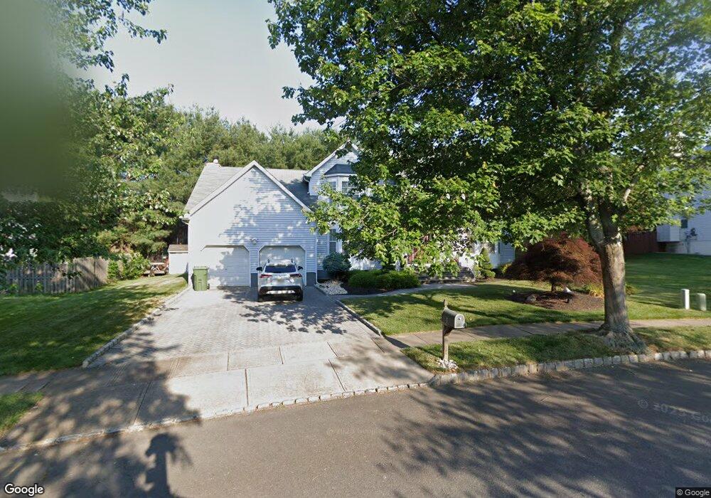
8 Saint Peter Dr South Amboy, NJ 08879
Estimated Value: $588,000 - $837,000
--
Bed
--
Bath
--
Sq Ft
0.27
Acres
About This Home
This home is located at 8 Saint Peter Dr, South Amboy, NJ 08879 and is currently estimated at $677,937. 8 Saint Peter Dr is a home located in Middlesex County with nearby schools including Sayreville War Memorial High School, St. Mary Elementary School, and New Road School of Parlin.
Ownership History
Date
Name
Owned For
Owner Type
Purchase Details
Closed on
Jul 27, 2020
Sold by
Timko Robert J and Timko Larisa
Bought by
Cordoba Jessica Diana and Timko Family Irrevocable Trust
Current Estimated Value
Purchase Details
Closed on
May 12, 1997
Sold by
Apple Wood Village
Bought by
Timko Robert and Timko Larisa
Home Financials for this Owner
Home Financials are based on the most recent Mortgage that was taken out on this home.
Original Mortgage
$125,000
Interest Rate
8.08%
Create a Home Valuation Report for This Property
The Home Valuation Report is an in-depth analysis detailing your home's value as well as a comparison with similar homes in the area
Home Values in the Area
Average Home Value in this Area
Purchase History
| Date | Buyer | Sale Price | Title Company |
|---|---|---|---|
| Cordoba Jessica Diana | -- | None Available | |
| Timko Family Irrevocable Trust | -- | Alguram Jason | |
| Timko Robert | $250,000 | -- |
Source: Public Records
Mortgage History
| Date | Status | Borrower | Loan Amount |
|---|---|---|---|
| Previous Owner | Timko Robert | $125,000 |
Source: Public Records
Tax History Compared to Growth
Tax History
| Year | Tax Paid | Tax Assessment Tax Assessment Total Assessment is a certain percentage of the fair market value that is determined by local assessors to be the total taxable value of land and additions on the property. | Land | Improvement |
|---|---|---|---|---|
| 2025 | $13,449 | $220,300 | $52,100 | $168,200 |
| 2024 | $13,077 | $220,300 | $52,100 | $168,200 |
| 2023 | $13,077 | $220,300 | $52,100 | $168,200 |
| 2022 | $12,216 | $220,300 | $52,100 | $168,200 |
| 2021 | $11,775 | $220,300 | $52,100 | $168,200 |
| 2020 | $11,775 | $220,300 | $52,100 | $168,200 |
| 2019 | $11,528 | $220,300 | $52,100 | $168,200 |
| 2018 | $11,321 | $220,300 | $52,100 | $168,200 |
| 2017 | $11,059 | $220,300 | $52,100 | $168,200 |
| 2016 | $10,764 | $220,300 | $52,100 | $168,200 |
| 2015 | $10,519 | $220,300 | $52,100 | $168,200 |
| 2014 | $10,237 | $220,300 | $52,100 | $168,200 |
Source: Public Records
Map
Nearby Homes
- 305 Sunshine Ct
- 380 Prospect St
- 10 Martha Blvd
- 741 Bordentown Ave
- 503 Woodland Ave
- 20 Gillen Dr
- 21 Luke St
- 1200 Ernston Rd
- 161 Manor St
- 1511 Pebble Place
- 158 Liberty St St
- 158 Liberty St
- 320 Parker Ave
- 21 Gordon Ave
- 1202 Harbor Club Dr
- 1902 Bayhead Dr
- 433 Gordon St
- 15 Bertram Ave
- 3014 Lighthouse Ln
- 3015 Lighthouse Ln
- 100 Merritt Ave
- 6 Saint Peter Dr
- 10 Saint Peter Dr
- 98 Merritt Ave
- 7 Saint Peter Dr
- 104 Merritt Ave
- 9 Saint Peter Dr
- 1 Slesinski Ct
- 12 Saint Peter Dr
- 96 Merritt Ave
- 106 Merritt Ave
- 99 Merritt Ave
- 5 Saint Peter Dr
- 11 Saint Peter Dr
- 9 Lani St
- 11 Anne Terrace
- 94 Merritt Ave
- 2 Slesinski Ct
- 14 Saint Peter Dr
- 3 Slesinski Ct