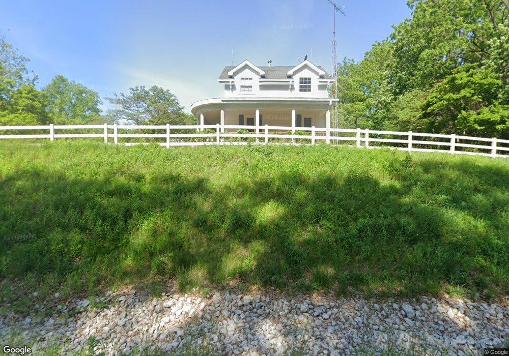
8 Smoke Rd Valparaiso, IN 46385
Porter County NeighborhoodEstimated Value: $399,000 - $426,000
3
Beds
3
Baths
1,944
Sq Ft
$210/Sq Ft
Est. Value
About This Home
This home is located at 8 Smoke Rd, Valparaiso, IN 46385 and is currently estimated at $408,995, approximately $210 per square foot. 8 Smoke Rd is a home located in Porter County with nearby schools including Morgan Township Elementary School and Morgan Township Middle/High School.
Ownership History
Date
Name
Owned For
Owner Type
Purchase Details
Closed on
Nov 10, 2020
Sold by
Davis Pamela and Pamela Davis Revocable Trust
Bought by
Davis Arthur O and Davis Pamela
Current Estimated Value
Purchase Details
Closed on
Mar 14, 2008
Sold by
Davis Arthur O and Davis Pamela
Bought by
Davis Pamela and Pamela Davis Revocable Trust
Purchase Details
Closed on
Mar 8, 2006
Sold by
Davis Arthur O and Davis Pamela
Bought by
Davis Arthur O and Davis Pamela
Create a Home Valuation Report for This Property
The Home Valuation Report is an in-depth analysis detailing your home's value as well as a comparison with similar homes in the area
Home Values in the Area
Average Home Value in this Area
Purchase History
| Date | Buyer | Sale Price | Title Company |
|---|---|---|---|
| Davis Arthur O | -- | None Available | |
| Arthur O Davis And Pamela Davis Revocable Tru | -- | None Listed On Document | |
| Davis Pamela | -- | None Available | |
| Davis Arthur O | -- | None Available | |
| Davis Arthur O | -- | None Available |
Source: Public Records
Tax History Compared to Growth
Tax History
| Year | Tax Paid | Tax Assessment Tax Assessment Total Assessment is a certain percentage of the fair market value that is determined by local assessors to be the total taxable value of land and additions on the property. | Land | Improvement |
|---|---|---|---|---|
| 2024 | $2,550 | $345,800 | $79,800 | $266,000 |
| 2023 | $2,504 | $312,000 | $70,300 | $241,700 |
| 2022 | $2,364 | $289,700 | $70,100 | $219,600 |
| 2021 | $2,482 | $274,100 | $70,000 | $204,100 |
| 2020 | $2,174 | $241,500 | $54,800 | $186,700 |
| 2019 | $2,021 | $213,100 | $54,900 | $158,200 |
| 2018 | $1,917 | $205,700 | $54,900 | $150,800 |
| 2017 | $1,913 | $205,000 | $55,000 | $150,000 |
| 2016 | $1,806 | $199,600 | $56,400 | $143,200 |
Source: Public Records
Map
Nearby Homes
- 0 Smoke Rd
- 48 E Division Rd
- 3152 Heavilin Rd
- 501 Eagle Ct
- 2655 Vivante Dr
- 3359 Blue Jay Dr
- 2054 Lawndale Dr
- 1954 Lawndale Dr
- 2658 Arran Quay Terrace
- 1556 Smoke Rd
- 1284 Rowley St
- 1465 Clark Rd
- 1952 Galena Ct
- 1659 Tippecanoe Ct
- 2551 Saint Road 2
- 3251 Mockingbird Ln
- 1153 Horse Prairie Ave
- 1356 Sugar Creek Ct
- 3353 Field Hawk Dr
- 1460 Swansea Ln