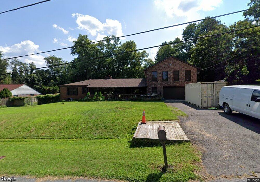
8 Stanley Ln Silver Spring, MD 20904
Estimated Value: $664,000 - $873,000
Studio
5
Baths
3,540
Sq Ft
$210/Sq Ft
Est. Value
About This Home
This home is located at 8 Stanley Ln, Silver Spring, MD 20904 and is currently estimated at $744,926, approximately $210 per square foot. 8 Stanley Ln is a home located in Montgomery County with nearby schools including Jackson Road Elementary School, White Oak Middle School, and Springbrook High School.
Ownership History
Date
Name
Owned For
Owner Type
Purchase Details
Closed on
Mar 14, 2008
Sold by
Clutch Dan B
Bought by
Clutch Dan B
Current Estimated Value
Home Financials for this Owner
Home Financials are based on the most recent Mortgage that was taken out on this home.
Original Mortgage
$416,000
Outstanding Balance
$261,379
Interest Rate
5.9%
Mortgage Type
Purchase Money Mortgage
Estimated Equity
$483,547
Purchase Details
Closed on
Feb 8, 2008
Sold by
Clutch Dan B
Bought by
Clutch Dan B
Home Financials for this Owner
Home Financials are based on the most recent Mortgage that was taken out on this home.
Original Mortgage
$416,000
Outstanding Balance
$261,379
Interest Rate
5.9%
Mortgage Type
Purchase Money Mortgage
Estimated Equity
$483,547
Create a Home Valuation Report for This Property
The Home Valuation Report is an in-depth analysis detailing your home's value as well as a comparison with similar homes in the area
Home Values in the Area
Average Home Value in this Area
Purchase History
| Date | Buyer | Sale Price | Title Company |
|---|---|---|---|
| Clutch Dan B | -- | -- | |
| Clutch Dan B | -- | -- |
Source: Public Records
Mortgage History
| Date | Status | Borrower | Loan Amount |
|---|---|---|---|
| Open | Clutch Dan B | $416,000 | |
| Closed | Clutch Dan B | $416,000 |
Source: Public Records
Tax History
| Year | Tax Paid | Tax Assessment Tax Assessment Total Assessment is a certain percentage of the fair market value that is determined by local assessors to be the total taxable value of land and additions on the property. | Land | Improvement |
|---|---|---|---|---|
| 2025 | $7,403 | $627,433 | -- | -- |
| 2024 | $7,403 | $578,467 | $0 | $0 |
| 2023 | $6,114 | $529,500 | $250,700 | $278,800 |
| 2022 | $5,290 | $486,000 | $0 | $0 |
| 2021 | $4,255 | $442,500 | $0 | $0 |
| 2020 | $4,255 | $399,000 | $250,700 | $148,300 |
| 2019 | $4,225 | $399,000 | $250,700 | $148,300 |
| 2018 | $4,206 | $399,000 | $250,700 | $148,300 |
| 2017 | $4,320 | $402,600 | $0 | $0 |
| 2016 | $4,536 | $393,567 | $0 | $0 |
| 2015 | $4,536 | $384,533 | $0 | $0 |
| 2014 | $4,536 | $375,500 | $0 | $0 |
Source: Public Records
Map
Nearby Homes
- 12916 Shaw Place
- 7 Shaw Ave
- 605 Rosemere Ave
- 115 Lillian Ln
- 13707 Notley Rd
- 13711 Notley Rd
- 816 Rosemere Ave
- 13719 Notley Rd
- 13704 New Hampshire Ave
- 606 Winhall Way
- 13715 Notley Rd
- 13137 Broadmore Rd
- 600 Seminole Creek Way
- 421 Beaumont Rd
- 609 Seminole Creek Way
- 604 Hawkesbury Terrace
- 513 Beaumont Rd
- 412 Vierling Dr
- 3 Shannon Ct
- 906 Venice Dr
- 4 Stanley Ln
- 12 Stanley Ln
- 13201 Andrew Dr
- 13217 Andrew Dr
- 13200 Bregman Rd
- 13207 Andrew Dr
- 13118 New Hampshire Ave
- 13113 Andrew Dr
- 11 Stanley Ln
- 13112 New Hampshire Ave
- 16 Stanley Ln
- 13200 New Hampshire Ave
- 13206 Bregman Rd
- 13205 Bregman Rd
- 13200 Andrew Dr
- 13116 Andrew Dr
- 13107 Andrew Dr
- 13106 New Hampshire Ave
- 13206 Andrew Dr
- 15 Stanley Ln
Your Personal Tour Guide
Ask me questions while you tour the home.