L
Seller's Agent in 2022
LINK Email Cache
LINK
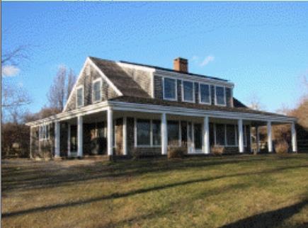

Estimated Value: $2,929,000 - $4,045,000
Not Listed in LINK
Last Agent to Sell the Property
LINK Email Cache
LINK Listed on: 12/30/2022
| Date | Buyer | Sale Price | Title Company |
|---|---|---|---|
| Tanglevine Property Llc | $2,800,000 | None Available | |
| Tanglevine Prop Gst Ir | -- | -- | |
| Tanglevine Prop Gst Ir | -- | -- | |
| Smith John | $217,500 | -- |
| Date | Status | Borrower | Loan Amount |
|---|---|---|---|
| Open | Tanglevine Property Llc | $1,200,000 | |
| Previous Owner | Smith John | $250,000 |
| Date | Event | Price | List to Sale | Price per Sq Ft |
|---|---|---|---|---|
| 12/30/2022 12/30/22 | Sold | $2,800,000 | -- | $962 / Sq Ft |
| Year | Tax Paid | Tax Assessment Tax Assessment Total Assessment is a certain percentage of the fair market value that is determined by local assessors to be the total taxable value of land and additions on the property. | Land | Improvement |
|---|---|---|---|---|
| 2025 | $5,992 | $2,663,100 | $1,461,000 | $1,202,100 |
| 2024 | $5,446 | $2,569,000 | $1,409,800 | $1,159,200 |
| 2023 | $5,016 | $1,907,400 | $1,205,400 | $702,000 |
| 2022 | $4,935 | $1,750,100 | $1,153,500 | $596,600 |
| 2021 | $4,844 | $1,664,600 | $1,153,500 | $511,100 |
| 2020 | $4,675 | $1,634,500 | $1,133,100 | $501,400 |
| 2019 | $4,612 | $1,601,300 | $1,133,100 | $468,200 |
| 2018 | $4,404 | $1,601,300 | $1,133,100 | $468,200 |
| 2017 | $4,273 | $1,594,500 | $1,129,800 | $464,700 |
| 2016 | $4,312 | $1,591,200 | $1,129,800 | $461,400 |
| 2015 | $4,199 | $1,596,700 | $1,129,800 | $466,900 |
| 2014 | $3,965 | $1,598,900 | $1,188,000 | $410,900 |
L
Seller's Agent in 2022
LINK Email Cache
LINK
Source: LINK (Vineyard)
MLS Number: 40395
APN: CHIL-000025-000000-000055
Ask me questions while you tour the home.