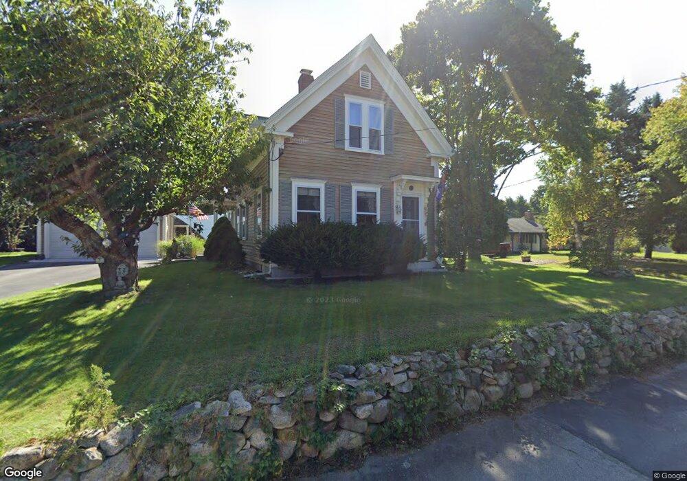
8 Timothy Ln Plymouth, MA 02360
Estimated Value: $593,462 - $757,000
3
Beds
2
Baths
1,560
Sq Ft
$424/Sq Ft
Est. Value
About This Home
This home is located at 8 Timothy Ln, Plymouth, MA 02360 and is currently estimated at $661,616, approximately $424 per square foot. 8 Timothy Ln is a home located in Plymouth County with nearby schools including Nathaniel Morton Elementary School, Plymouth Community Intermediate, and Plymouth North High School.
Ownership History
Date
Name
Owned For
Owner Type
Purchase Details
Closed on
Feb 23, 1988
Sold by
Westcott Chas M
Bought by
Veiga Maurice J
Current Estimated Value
Create a Home Valuation Report for This Property
The Home Valuation Report is an in-depth analysis detailing your home's value as well as a comparison with similar homes in the area
Home Values in the Area
Average Home Value in this Area
Purchase History
| Date | Buyer | Sale Price | Title Company |
|---|---|---|---|
| Veiga Maurice J | $148,900 | -- |
Source: Public Records
Mortgage History
| Date | Status | Borrower | Loan Amount |
|---|---|---|---|
| Open | Veiga Maurice J | $30,000 | |
| Open | Veiga Maurice J | $150,000 | |
| Closed | Veiga Maurice J | $32,206 | |
| Closed | Veiga Maurice J | $104,000 |
Source: Public Records
Tax History Compared to Growth
Tax History
| Year | Tax Paid | Tax Assessment Tax Assessment Total Assessment is a certain percentage of the fair market value that is determined by local assessors to be the total taxable value of land and additions on the property. | Land | Improvement |
|---|---|---|---|---|
| 2025 | $6,193 | $488,000 | $277,200 | $210,800 |
| 2024 | $5,874 | $456,400 | $261,200 | $195,200 |
| 2023 | $5,614 | $409,500 | $226,200 | $183,300 |
| 2022 | $5,976 | $387,300 | $216,100 | $171,200 |
| 2021 | $5,750 | $355,800 | $216,100 | $139,700 |
| 2020 | $5,618 | $343,600 | $205,100 | $138,500 |
| 2019 | $5,536 | $334,700 | $196,100 | $138,600 |
| 2018 | $5,160 | $313,500 | $176,100 | $137,400 |
| 2017 | $5,045 | $304,300 | $176,100 | $128,200 |
| 2016 | $4,953 | $304,400 | $176,100 | $128,300 |
| 2015 | $4,732 | $304,500 | $176,100 | $128,400 |
| 2014 | $4,471 | $295,500 | $176,100 | $119,400 |
Source: Public Records
Map
Nearby Homes
- 253 Sandwich St
- 9 Hill Dale Rd
- 15 Coles Ln
- 4 Nook Rd
- 72 Warren Ave
- 45 Curtis Dr
- 69 Cliff St
- 27 1/2 Fremont St Unit 2
- 14-16 South St
- 57 A Stafford St Unit 57A
- 60 Bramhall Ln
- 14 Meadowbrook Dr
- 18 River St
- 12 Old Barn Rd
- 8 Carver St
- 91 Newfield St Unit 34
- 91 Newfield St Unit 23
- 49 Bumble Bee Dr
- 5 Bumble Bee Dr
- 46 Sandwich Rd Unit 26
- 6 Timothy Ln
- 10 Timothy Ln
- 12 Timothy Ln
- 11 Timothy Ln
- 7 Timothy Ln
- 260 Sandwich St
- 262 Sandwich St
- 3 Timothy Ln
- 268 Sandwich St
- 276R Sandwich St
- 254 Sandwich St
- 264 Sandwich St
- 250 Sandwich St
- 266 Sandwich St
- 29 Warren Ave
- 263 Sandwich St
- 265 Sandwich St
- 261 Sandwich St
- 274 Sandwich St
- 248 Sandwich St Unit 2N