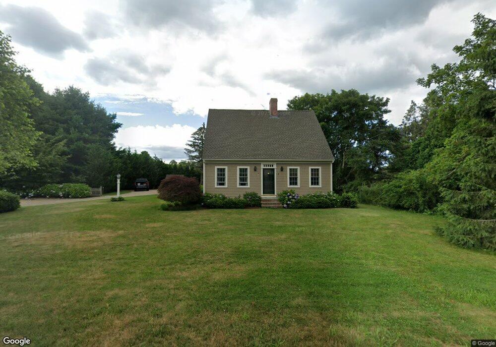
8 Upland Way Mattapoisett, MA 02739
Estimated Value: $754,000 - $927,000
3
Beds
3
Baths
2,240
Sq Ft
$374/Sq Ft
Est. Value
About This Home
This home is located at 8 Upland Way, Mattapoisett, MA 02739 and is currently estimated at $836,736, approximately $373 per square foot. 8 Upland Way is a home located in Plymouth County with nearby schools including Center School, Old Hammondtown Elementary, and Old Rochester Regional High School.
Ownership History
Date
Name
Owned For
Owner Type
Purchase Details
Closed on
Jun 5, 2014
Sold by
Mayer Donald M and Mayer Janet E
Bought by
Mayer Irt and Mayer
Current Estimated Value
Purchase Details
Closed on
Oct 12, 2012
Sold by
Clough William P and Clough Nannie W
Bought by
Mayer Donald M and Mayer Janet E
Purchase Details
Closed on
Jun 20, 2002
Sold by
Parker Scott M and Parker Christine
Bought by
Clough William P and Clough Nannie Wb
Purchase Details
Closed on
Aug 11, 1998
Sold by
Est Sylvia Frank F and Nelsen Doreen F
Bought by
Parker Scott
Create a Home Valuation Report for This Property
The Home Valuation Report is an in-depth analysis detailing your home's value as well as a comparison with similar homes in the area
Home Values in the Area
Average Home Value in this Area
Purchase History
| Date | Buyer | Sale Price | Title Company |
|---|---|---|---|
| Mayer Irt | -- | -- | |
| Mayer Irt | -- | -- | |
| Mayer Donald M | $383,000 | -- | |
| Mayer Donald M | $383,000 | -- | |
| Clough William P | $394,500 | -- | |
| Clough William P | $394,500 | -- | |
| Parker Scott | $65,000 | -- |
Source: Public Records
Mortgage History
| Date | Status | Borrower | Loan Amount |
|---|---|---|---|
| Previous Owner | Parker Scott | $322,040 | |
| Previous Owner | Parker Scott | $50,000 |
Source: Public Records
Tax History Compared to Growth
Tax History
| Year | Tax Paid | Tax Assessment Tax Assessment Total Assessment is a certain percentage of the fair market value that is determined by local assessors to be the total taxable value of land and additions on the property. | Land | Improvement |
|---|---|---|---|---|
| 2025 | $6,696 | $622,300 | $213,400 | $408,900 |
| 2024 | $6,491 | $617,600 | $213,400 | $404,200 |
| 2023 | $6,841 | $608,100 | $208,600 | $399,500 |
| 2022 | $6,530 | $526,600 | $173,900 | $352,700 |
| 2021 | $5,761 | $444,500 | $151,200 | $293,300 |
| 2020 | $5,416 | $401,500 | $144,000 | $257,500 |
| 2019 | $5,304 | $401,500 | $144,000 | $257,500 |
| 2018 | $5,182 | $398,000 | $152,900 | $245,100 |
| 2017 | $5,224 | $399,700 | $165,600 | $234,100 |
| 2016 | $4,901 | $371,300 | $159,300 | $212,000 |
| 2015 | $4,692 | $360,900 | $150,400 | $210,500 |
| 2014 | $4,813 | $378,400 | $152,900 | $225,500 |
Source: Public Records
Map
Nearby Homes
- 35 North St
- 9 Hitching Post Rd
- 12 Cannon St
- 7 Pearl St
- 8 Captains Ln
- 11 Captains Ln
- 13 Park Place
- 52 Prince Snow Cir
- 47 Fairhaven Rd
- 15 Ned's Point Rd
- 19 High Ridge Dr
- 31 Split Rock Ln
- 83 Fairhaven Rd
- 1 Starboard Way
- 41 Starboard Way
- 0 Whalers Way
- 3 Rock St
- 6 Ocean Breeze Ln
- 0 Harbor Acres Ln - Lot B
- 1 Angelica Ave
- 8 Upland Way
- 6 Upland Way
- 10 Upland Way
- 33 County Rd Unit Retail
- 33 County Rd Unit 1
- 33 County Rd Unit R1
- 33 County Rd Unit 4
- 33 County Rd Unit 6
- 33 County Rd Unit Deli/Cafe'
- 9 Upland Way
- 0 Marthas Vineyard Dr Unit 72446446
- 0 Marthas Vineyard Dr Unit 72446043
- 0 Marthas Vineyard Dr Unit 72446036
- 0 Marthas Vineyard Dr Unit 72446028
- 0 Marthas Vineyard Dr Unit 72446023
- 0 Address Withheld Unit 72427403
- 0 Cuttyhunk Dr Unit 1216773
- 0 Cuttyhunk Dr Unit 1216770
- Lot 3 Parsons Ln
- 0 Cuttyhunk Dr Unit 72446078