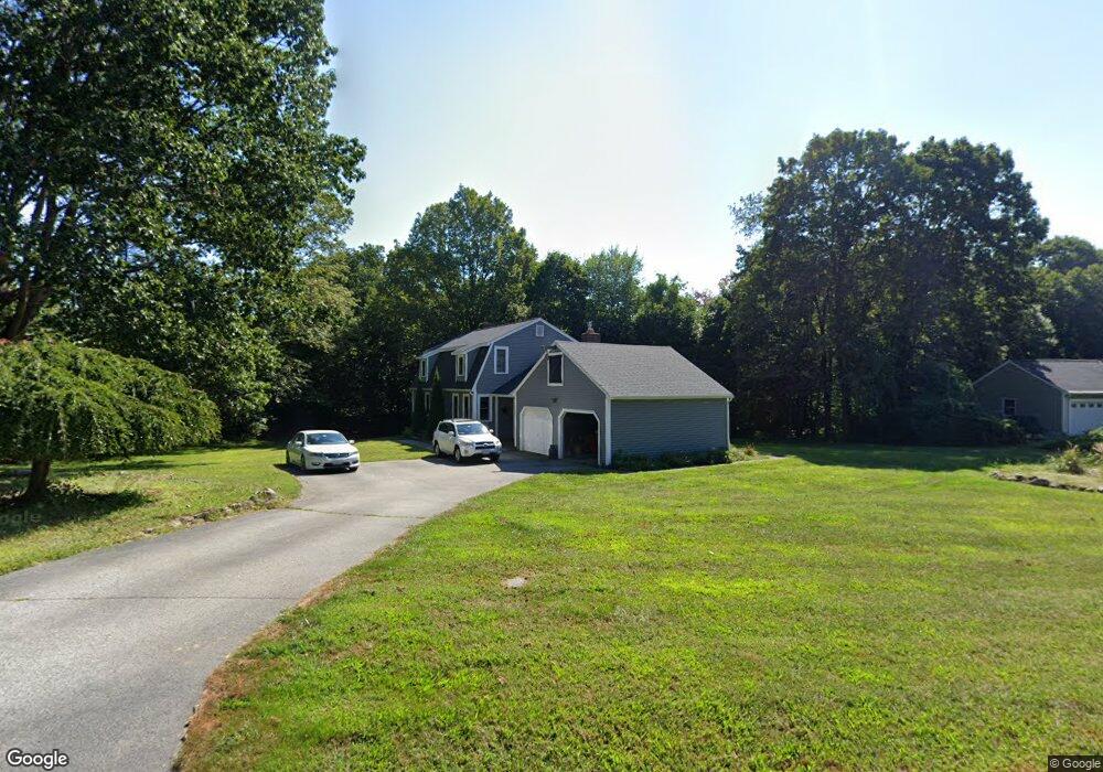
8 Walcott Cir Marlborough, MA 01752
Estimated Value: $647,000 - $708,000
3
Beds
2
Baths
1,824
Sq Ft
$370/Sq Ft
Est. Value
About This Home
This home is located at 8 Walcott Cir, Marlborough, MA 01752 and is currently estimated at $675,744, approximately $370 per square foot. 8 Walcott Cir is a home located in Middlesex County with nearby schools including Marlborough High School, Advanced Math & Science Academy, and New Covenant Christian School.
Ownership History
Date
Name
Owned For
Owner Type
Purchase Details
Closed on
Jun 26, 2008
Sold by
Jerry Andrew F and Jerry Carol B
Bought by
Landry Diane M and Landry Peter D
Current Estimated Value
Home Financials for this Owner
Home Financials are based on the most recent Mortgage that was taken out on this home.
Original Mortgage
$288,000
Interest Rate
6.07%
Mortgage Type
Purchase Money Mortgage
Purchase Details
Closed on
Aug 27, 1987
Sold by
Navedonsk Charles P
Bought by
Gerry Andrew F
Create a Home Valuation Report for This Property
The Home Valuation Report is an in-depth analysis detailing your home's value as well as a comparison with similar homes in the area
Home Values in the Area
Average Home Value in this Area
Purchase History
| Date | Buyer | Sale Price | Title Company |
|---|---|---|---|
| Landry Diane M | $360,000 | -- | |
| Gerry Andrew F | $227,450 | -- |
Source: Public Records
Mortgage History
| Date | Status | Borrower | Loan Amount |
|---|---|---|---|
| Open | Gerry Andrew F | $292,000 | |
| Closed | Gerry Andrew F | $293,000 | |
| Closed | Landry Diane M | $288,000 |
Source: Public Records
Tax History Compared to Growth
Tax History
| Year | Tax Paid | Tax Assessment Tax Assessment Total Assessment is a certain percentage of the fair market value that is determined by local assessors to be the total taxable value of land and additions on the property. | Land | Improvement |
|---|---|---|---|---|
| 2025 | $5,965 | $605,000 | $259,500 | $345,500 |
| 2024 | $5,850 | $571,300 | $236,000 | $335,300 |
| 2023 | $6,189 | $536,300 | $198,200 | $338,100 |
| 2022 | $6,067 | $462,400 | $188,700 | $273,700 |
| 2021 | $6,025 | $436,600 | $160,200 | $276,400 |
| 2020 | $5,838 | $411,700 | $147,100 | $264,600 |
| 2019 | $5,641 | $400,900 | $144,200 | $256,700 |
| 2018 | $5,586 | $381,800 | $126,700 | $255,100 |
| 2017 | $5,348 | $349,100 | $124,900 | $224,200 |
| 2016 | $5,361 | $349,500 | $124,900 | $224,600 |
| 2015 | $5,421 | $344,000 | $128,800 | $215,200 |
Source: Public Records
Map
Nearby Homes
- 273 W Main St Unit B12
- 11 Whispering Brook Rd Unit 55
- 30 Broad St Unit 104
- 30A Winter Ave
- 39 Desimone Dr
- 76 Broad St
- 11 Paris St
- 115 W Main St
- 102 Liberty St
- 32 Water St
- 156 Chestnut St
- 61 Fairmount St Unit 11
- 2 Adams St
- 87 Neil St
- 110 Pleasant St Unit 401
- 72 Chestnut St
- 111 Howe St
- 118 Elm St
- 53 Mechanic St
- 3 Madison St