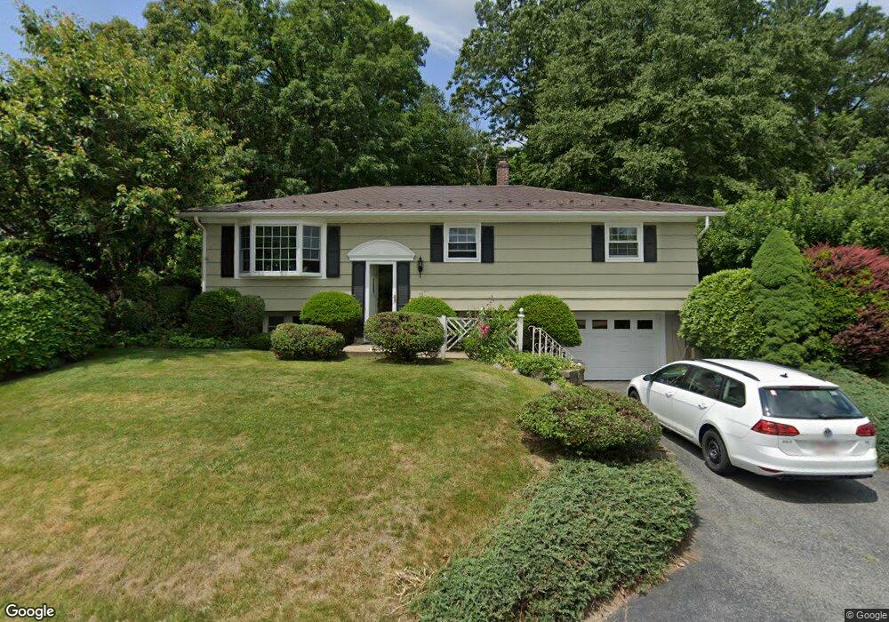
8 Warren St Millbury, MA 01527
Estimated Value: $435,000 - $476,000
3
Beds
1
Bath
1,468
Sq Ft
$310/Sq Ft
Est. Value
About This Home
This home is located at 8 Warren St, Millbury, MA 01527 and is currently estimated at $455,344, approximately $310 per square foot. 8 Warren St is a home located in Worcester County with nearby schools including Elmwood Street Elementary School, Raymond E. Shaw Elementary School, and Millbury Junior/Senior High School.
Ownership History
Date
Name
Owned For
Owner Type
Purchase Details
Closed on
Sep 1, 2004
Sold by
Chabot Maureen E and Chabot Raymond P
Bought by
Brawn Mary K and Brawn Stephen J
Current Estimated Value
Home Financials for this Owner
Home Financials are based on the most recent Mortgage that was taken out on this home.
Original Mortgage
$239,000
Outstanding Balance
$117,755
Interest Rate
6.01%
Mortgage Type
Purchase Money Mortgage
Estimated Equity
$337,589
Purchase Details
Closed on
Dec 31, 1991
Sold by
Hayward Helen M and Hall Eleanor
Bought by
Lorusso Ralph and Lorusso Lorie A
Create a Home Valuation Report for This Property
The Home Valuation Report is an in-depth analysis detailing your home's value as well as a comparison with similar homes in the area
Home Values in the Area
Average Home Value in this Area
Purchase History
| Date | Buyer | Sale Price | Title Company |
|---|---|---|---|
| Brawn Mary K | $299,000 | -- | |
| Brawn Mary K | $299,000 | -- | |
| Lorusso Ralph | $3,000 | -- | |
| Lorusso Ralph | $3,000 | -- |
Source: Public Records
Mortgage History
| Date | Status | Borrower | Loan Amount |
|---|---|---|---|
| Open | Brawn Mary K | $239,000 | |
| Closed | Lorusso Ralph | $239,000 | |
| Previous Owner | Lorusso Ralph | $47,000 | |
| Previous Owner | Lorusso Ralph | $15,000 |
Source: Public Records
Tax History
| Year | Tax Paid | Tax Assessment Tax Assessment Total Assessment is a certain percentage of the fair market value that is determined by local assessors to be the total taxable value of land and additions on the property. | Land | Improvement |
|---|---|---|---|---|
| 2025 | $5,169 | $386,000 | $110,200 | $275,800 |
| 2024 | $4,740 | $358,300 | $102,100 | $256,200 |
| 2023 | $4,342 | $300,500 | $71,700 | $228,800 |
| 2022 | $4,079 | $271,900 | $71,700 | $200,200 |
| 2021 | $11,075 | $260,100 | $71,700 | $188,400 |
| 2020 | $4,116 | $268,500 | $71,700 | $196,800 |
| 2019 | $3,804 | $240,000 | $65,100 | $174,900 |
| 2018 | $3,299 | $229,900 | $65,100 | $164,800 |
| 2017 | $3,575 | $217,600 | $65,100 | $152,500 |
| 2016 | $3,280 | $199,300 | $65,100 | $134,200 |
| 2015 | $3,262 | $198,200 | $69,200 | $129,000 |
| 2014 | $3,391 | $198,300 | $69,200 | $129,100 |
Source: Public Records
Map
Nearby Homes
- 2 Wilson Rd Unit B
- 2 Wilson Rd Unit A
- 2 Riverlin Pkwy
- 25 Upton St
- 2 Diane St
- 8 Lincoln Ave
- 18 Lincoln Ave
- 17 Lincoln Ave
- 300 Millbury Ave
- 10 Logan's Run Unit 10
- 75 Main St
- 12 Irene Ct
- 7 Canal St
- 37-39 Main St
- 0 Worcester Providence Turnpike
- 46 Lexington Rd
- 5 Ann Dr Unit 5
- 4 John Dr
- 38 Garnet St
- Lot 1 Cooper Rd
Your Personal Tour Guide
Ask me questions while you tour the home.