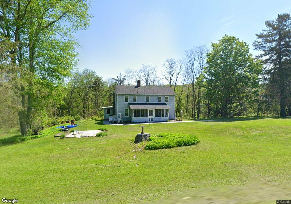
80 Bates Rd Honesdale, PA 18431
Estimated Value: $236,000 - $347,000
5
Beds
1
Bath
1,971
Sq Ft
$156/Sq Ft
Est. Value
About This Home
This home is located at 80 Bates Rd, Honesdale, PA 18431 and is currently estimated at $306,956, approximately $155 per square foot. 80 Bates Rd is a home located in Wayne County with nearby schools including Honesdale High School.
Ownership History
Date
Name
Owned For
Owner Type
Purchase Details
Closed on
Nov 19, 2019
Sold by
Martin Robert P and Martin Diane L
Bought by
Martin Robert P and Martin Diane L
Current Estimated Value
Purchase Details
Closed on
Jun 19, 2007
Sold by
Martin James W and Martin Frances G
Bought by
Martin James W and Martin Frances G
Purchase Details
Closed on
Sep 26, 2006
Sold by
Martin Arline G
Bought by
Martin James W
Purchase Details
Closed on
Nov 10, 2005
Sold by
Brill Ronald F
Bought by
Meagher Timothy R
Home Financials for this Owner
Home Financials are based on the most recent Mortgage that was taken out on this home.
Original Mortgage
$130,150
Outstanding Balance
$74,371
Interest Rate
6.75%
Mortgage Type
Assumption
Estimated Equity
$232,585
Create a Home Valuation Report for This Property
The Home Valuation Report is an in-depth analysis detailing your home's value as well as a comparison with similar homes in the area
Home Values in the Area
Average Home Value in this Area
Purchase History
| Date | Buyer | Sale Price | Title Company |
|---|---|---|---|
| Martin Robert P | -- | None Available | |
| Martin James W | -- | None Available | |
| Martin James W | -- | None Available | |
| Meagher Timothy R | $137,000 | None Available |
Source: Public Records
Mortgage History
| Date | Status | Borrower | Loan Amount |
|---|---|---|---|
| Open | Meagher Timothy R | $130,150 |
Source: Public Records
Tax History Compared to Growth
Tax History
| Year | Tax Paid | Tax Assessment Tax Assessment Total Assessment is a certain percentage of the fair market value that is determined by local assessors to be the total taxable value of land and additions on the property. | Land | Improvement |
|---|---|---|---|---|
| 2025 | $3,563 | $215,700 | $94,400 | $121,300 |
| 2024 | $3,399 | $215,700 | $94,400 | $121,300 |
| 2023 | $4,826 | $215,700 | $94,400 | $121,300 |
| 2022 | $3,564 | $148,900 | $53,800 | $95,100 |
| 2021 | $3,528 | $148,900 | $53,800 | $95,100 |
| 2020 | $3,528 | $148,900 | $53,800 | $95,100 |
| 2019 | $3,291 | $148,900 | $53,800 | $95,100 |
| 2018 | $3,203 | $148,900 | $53,800 | $95,100 |
| 2017 | $642 | $148,900 | $53,800 | $95,100 |
| 2016 | $3,074 | $151,500 | $53,800 | $97,700 |
| 2014 | -- | $148,500 | $53,800 | $94,700 |
Source: Public Records
Map
Nearby Homes
- 19 Oregon Turnpike
- 0 Bryn Mawr Rd
- 105 Grimms Rd
- 401 Wayne St
- 0 Highhouse Rd
- 25 Leaf Dr
- 15 Rose Land Dr
- 19 Bethany Turnpike
- 22 Vanishing Pond Rd
- 52 Laurel Dr
- 560 Johnson Ln
- 1797 N Main St
- 1223 Dyberry Place
- 1226 Dyberry Place
- 649 Creek Dr
- 2040 Roosevelt Hwy
- 729 High St
- 910 Maple Ave
- 0 Town Hill Rd
- 721 Maple Ave