S
Seller's Agent in 2025
Sara Weber
Cowan, Realtors
(419) 303-9302
54 Total Sales
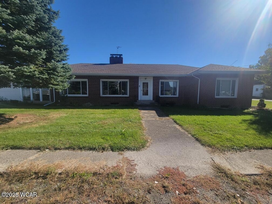


Updated Ranch-Style Retreat with Fireplace Charm & Spa-Like Bath on Nearly Half an Acre!
Step into comfort and character with this beautifully maintained ranch-style home, nestled on a spacious .41-acre lot with mature trees and plenty of room to roam. Boasting 3 bedrooms, 2 fireplaces, and a host of updates, this property offers the best of cozy living and modern touches.
You'll love the inviting living room, filled with natural light from oversized front windows and warmed by a stunning brick fireplace with custom woodwork—a perfect centerpiece for relaxing or entertaining. The rich hardwood floors flow throughout the space, complementing the neutral palette and bright, open layout.
The eat-in kitchen is just steps away, ready for daily meals or gatherings, with plenty of space for a large dining table. Down the hall, the fully renovated bathroom is a showstopper—featuring elegant marble-look tile, a freestanding soaking tub, a glass-enclosed walk-in shower, and dual vanities that bring spa-quality luxury into your daily routine.
Need more space? The full basement offers endless possibilities for storage, a rec room, or workshop. Outside, a 2-car garage, shed, and outbuilding provide tons of flexibility for hobbies, tools, or even small business needs.
Whether you're relaxing by the fire, enjoying a soak in the tub, or watching the sunset from your private backyard, this home has all the ingredients for peaceful, practical living.
Last Agent to Sell the Property
Cowan, Realtors License #2016000963 Listed on: 10/10/2025
| Date | Type | Sale Price | Title Company |
|---|---|---|---|
| Warranty Deed | $225,000 | None Listed On Document | |
| Quit Claim Deed | -- | None Listed On Document | |
| Warranty Deed | $90,000 | Attorney | |
| Deed | $75,200 | -- |
| Date | Event | Price | List to Sale | Price per Sq Ft |
|---|---|---|---|---|
| 10/31/2025 10/31/25 | Sold | $225,000 | 0.0% | $108 / Sq Ft |
| 10/20/2025 10/20/25 | Pending | -- | -- | -- |
| 10/10/2025 10/10/25 | For Sale | $225,000 | -- | $108 / Sq Ft |
| Year | Tax Paid | Tax Assessment Tax Assessment Total Assessment is a certain percentage of the fair market value that is determined by local assessors to be the total taxable value of land and additions on the property. | Land | Improvement |
|---|---|---|---|---|
| 2025 | $2,951 | $58,150 | $7,570 | $50,580 |
| 2024 | $2,951 | $58,150 | $7,570 | $50,580 |
| 2023 | $2,042 | $58,150 | $7,570 | $50,580 |
| 2022 | $1,650 | $43,350 | $6,930 | $36,420 |
| 2021 | $1,650 | $43,350 | $6,930 | $36,420 |
| 2020 | $1,657 | $43,351 | $6,930 | $36,421 |
| 2019 | $1,427 | $36,127 | $5,775 | $30,352 |
| 2018 | $1,378 | $36,313 | $5,775 | $30,538 |
| 2017 | $1,241 | $32,834 | $2,604 | $30,230 |
| 2016 | $1,079 | $28,707 | $2,478 | $26,229 |
| 2015 | $1,078 | $28,707 | $2,478 | $26,229 |
| 2014 | $1,089 | $28,707 | $2,478 | $26,229 |
S
Seller's Agent in 2025
Sara Weber
Cowan, Realtors
(419) 303-9302
54 Total Sales
K
Buyer's Agent in 2025
Kurt Brandehoff
Binkley Real Estate- Wapakoneta
(419) 738-3232
117 Total Sales
Source: West Central Association of REALTORS® (OH)
MLS Number: 308501
APN: L33-200-018-00
Ask me questions while you tour the home.
