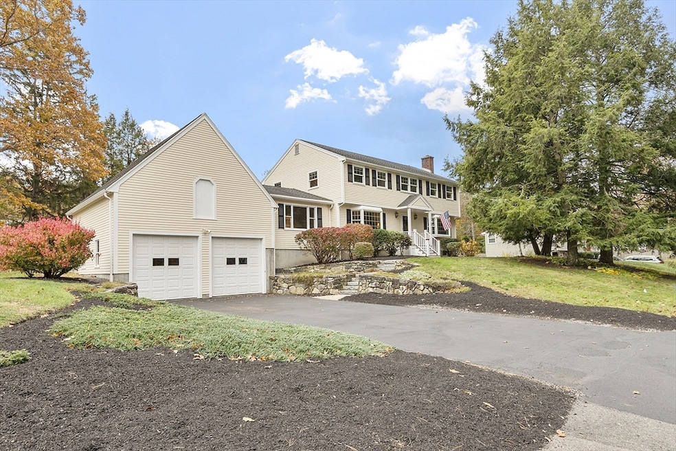
80 N Branch Rd Concord, MA 01742
Estimated payment $6,949/month
Highlights
- Golf Course Community
- Medical Services
- Landscaped Professionally
- Thoreau Elementary School Rated A
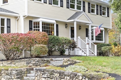
- Colonial Architecture
- Deck
About This Home
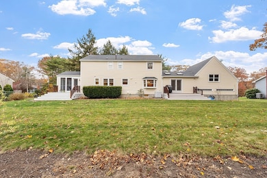
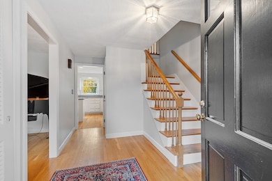
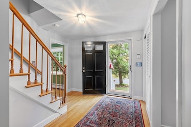
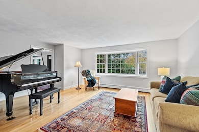
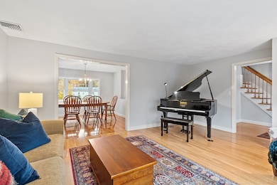
A timeless Colonial in one of West Concord’s most coveted neighborhoods, this charming home combines comfort with classic character. You’ll find a warm and inviting layout featuring generous living spaces.The main level includes a light-filled family room, a fireplaced dining room, a formal living room, and a cozy kitchen---ideal for everyday living and entertaining.The beautiful screened porch offers peaceful southern exposure to watch the seasons change.The finished lower level has a large playroom or TV room, generous office space and large unfinished storage and /or exercise room.You will appreciate this home's significant improvements, along with the careful maintenance it has received over the years. Close to West Concord Village with easy access to local shops, the commuter rail, restaurants and major commuter routes. Whether you're heading into Boston or exploring the scenic charm of Concord, this location has it all.
Home Details
Home Type
- Single Family
Est. Annual Taxes
- $13,172
Year Built
- Built in 1967
Lot Details
- 0.46 Acre Lot
- Cul-De-Sac
- Property has an invisible fence for dogs
- Landscaped Professionally
- Property is zoned Res B
Parking
- 2 Car Attached Garage
- Parking Storage or Cabinetry
- Workshop in Garage
- Garage Door Opener
- Driveway
- Open Parking
Home Design
- Colonial Architecture
- Shingle Roof
- Concrete Perimeter Foundation
Interior Spaces
- Beamed Ceilings
- Ceiling Fan
- Skylights
- Recessed Lighting
- Bay Window
- French Doors
- Entryway
- Dining Room with Fireplace
- Home Office
- Play Room
- Screened Porch
- Storage
- Home Security System
Kitchen
- Oven
- Range
- Freezer
- Dishwasher
- Kitchen Island
Flooring
- Wood
- Wall to Wall Carpet
- Ceramic Tile
- Vinyl
Bedrooms and Bathrooms
- 4 Bedrooms
- Primary bedroom located on second floor
- Pedestal Sink
- Separate Shower
- Linen Closet In Bathroom
Laundry
- Laundry on main level
- Laundry in Bathroom
- Washer and Electric Dryer Hookup
Partially Finished Basement
- Basement Fills Entire Space Under The House
- Interior Basement Entry
- Garage Access
Outdoor Features
- Deck
- Rain Gutters
Location
- Property is near public transit
- Property is near schools
Schools
- Thoreau Elementary School
- Concord Middle School
- Concord Carlisle High School
Utilities
- Central Air
- 1 Cooling Zone
- 5 Heating Zones
- Heating System Uses Oil
- Radiant Heating System
- Baseboard Heating
- Water Heater
- Private Sewer
- High Speed Internet
Listing and Financial Details
- Assessor Parcel Number 456436
Community Details
Overview
- No Home Owners Association
Amenities
- Medical Services
- Shops
Recreation
- Golf Course Community
- Tennis Courts
- Community Pool
- Park
- Bike Trail
Map
Home Values in the Area
Average Home Value in this Area
Tax History
| Year | Tax Paid | Tax Assessment Tax Assessment Total Assessment is a certain percentage of the fair market value that is determined by local assessors to be the total taxable value of land and additions on the property. | Land | Improvement |
|---|---|---|---|---|
| 2025 | $13,172 | $993,400 | $378,000 | $615,400 |
| 2024 | $13,246 | $1,008,800 | $378,000 | $630,800 |
| 2023 | $11,865 | $915,500 | $315,000 | $600,500 |
| 2022 | $11,511 | $779,900 | $279,500 | $500,400 |
| 2021 | $11,019 | $748,600 | $279,500 | $469,100 |
| 2020 | $10,712 | $752,800 | $279,500 | $473,300 |
| 2019 | $10,431 | $735,100 | $298,000 | $437,100 |
| 2018 | $10,397 | $727,600 | $296,500 | $431,100 |
| 2017 | $9,811 | $697,300 | $266,200 | $431,100 |
| 2016 | $9,698 | $696,700 | $266,200 | $430,500 |
| 2015 | $9,151 | $640,400 | $246,600 | $393,800 |
Property History
| Date | Event | Price | List to Sale | Price per Sq Ft |
|---|---|---|---|---|
| 11/10/2025 11/10/25 | Pending | -- | -- | -- |
| 11/06/2025 11/06/25 | For Sale | $1,110,000 | -- | $336 / Sq Ft |
Purchase History
| Date | Type | Sale Price | Title Company |
|---|---|---|---|
| Deed | $420,000 | -- |
Mortgage History
| Date | Status | Loan Amount | Loan Type |
|---|---|---|---|
| Open | $297,500 | No Value Available |
Source: MLS Property Information Network (MLS PIN)
MLS Number: 73452271
APN: CONC-000011B-002326-000008
Disclaimer: Certain information contained herein is derived from information provided by parties other than Homes.com. All information provided is deemed reliable, but is not guaranteed to be accurate and should be independently verified.
![]() The property listing data and information, or the Images, set forth herein were provided to MLS Property Information Network, Inc. from third party sources, including sellers, lessors and public records, and were compiled by MLS Property Information Network, Inc. The property listing data and information, and the Images, are for the personal, non-commercial use of consumers having a good faith interest in purchasing or leasing listed properties of the type displayed to them and may not be used for any purpose other than to identify prospective properties which such consumers may have a good faith interest in purchasing or leasing. MLS Property Information Network, Inc. and its subscribers disclaim any and all representations and warranties as to the accuracy of the property listing data and information, or as to the accuracy of any of the Images, set forth herein.
The property listing data and information, or the Images, set forth herein were provided to MLS Property Information Network, Inc. from third party sources, including sellers, lessors and public records, and were compiled by MLS Property Information Network, Inc. The property listing data and information, and the Images, are for the personal, non-commercial use of consumers having a good faith interest in purchasing or leasing listed properties of the type displayed to them and may not be used for any purpose other than to identify prospective properties which such consumers may have a good faith interest in purchasing or leasing. MLS Property Information Network, Inc. and its subscribers disclaim any and all representations and warranties as to the accuracy of the property listing data and information, or as to the accuracy of any of the Images, set forth herein.
- 1844 Main St Unit 1844
- 37 Water St
- 27 Water St
- 1687 Main St
- 9 Black Birch Ln Unit 9
- 96 Forest Ridge Rd Unit 96
- 65 Summit St
- 29 Black Birch Ln Unit 29
- 70 Hillside Ave
- 31 Drummer Rd Unit 31
- 132 Parker St Unit G5
- 369 Border Rd
- 70 McCallar Ln
- 128 Parker St Unit 3B
- 102 Highland St
- 118 Parker St Unit 16
- 1 Maillet Dr
- 2 Clover Hill Rd
- 111 Central St
- 114 Upland Rd
