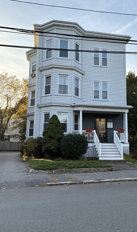
80 Norfolk Ave Unit 1 Swampscott, MA 01907
Estimated payment $2,915/month
Highlights
- Medical Services
- 3-minute walk to Swampscott
- Wood Flooring
- Swampscott High School Rated A-
- Property is near public transit
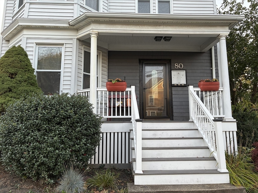
- Porch
About This Home
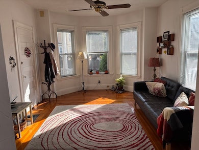
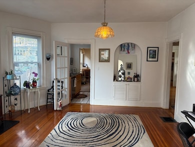
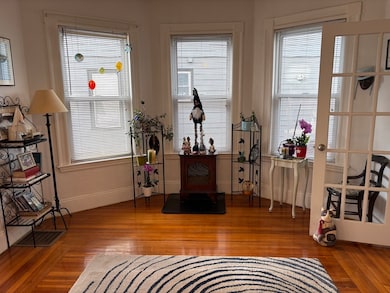
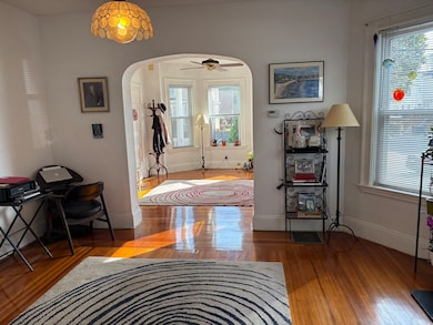
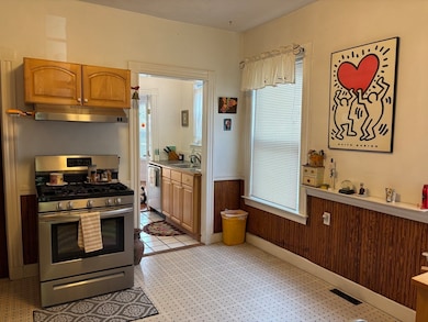
Welcome to a sun-filled condo, near the Swampscott train station for commuters, and the beach for relaxation. This 1200 s.f. condo features six rooms, with 3 bedrooms.One includes built-in bunk bed with desk area below, another includes built in Ikea storage unit. The kitchen has a large pantry, as well as a separate butler's pantry area with sink, disposal, dishwasher and bulit-in china cabinet. Living room and dining room with hardwood throughout, large windows, and a private deck in the back. One assigned off-street parking space. Dedicated storage area in basement. There are no large expenditures expected, and the low HOA fee is only $200 a month. This condo is available for a quick close if that is desirable to the buyer. Showings available by appointment this week at the Open House on Saturday, 11/8 from 11-1.
Property Details
Home Type
- Condominium
Est. Annual Taxes
- $4,132
Year Built
- Built in 1930
HOA Fees
- $200 Monthly HOA Fees
Home Design
- Entry on the 1st floor
- Frame Construction
- Shingle Roof
Interior Spaces
- 1,200 Sq Ft Home
- 3-Story Property
- Wood Flooring
- Basement
Kitchen
- Range
- Freezer
- Dishwasher
- Disposal
Bedrooms and Bathrooms
- 3 Bedrooms
- 1 Full Bathroom
Laundry
- Dryer
- Washer
Parking
- 1 Car Parking Space
- Assigned Parking
Utilities
- No Cooling
- Forced Air Heating System
- 1 Heating Zone
- Heating System Uses Natural Gas
- 100 Amp Service
Additional Features
- Porch
- Property is near public transit
Listing and Financial Details
- Assessor Parcel Number 3604993
Community Details
Overview
- Association fees include water, sewer, insurance, maintenance structure, snow removal
- 3 Units
Amenities
- Medical Services
- Common Area
- Shops
Recreation
- Park
Pet Policy
- Call for details about the types of pets allowed
Map
Home Values in the Area
Average Home Value in this Area
Tax History
| Year | Tax Paid | Tax Assessment Tax Assessment Total Assessment is a certain percentage of the fair market value that is determined by local assessors to be the total taxable value of land and additions on the property. | Land | Improvement |
|---|---|---|---|---|
| 2025 | $4,125 | $359,600 | $0 | $359,600 |
| 2024 | $3,701 | $322,100 | $0 | $322,100 |
| 2023 | $3,448 | $293,700 | $0 | $293,700 |
| 2022 | $3,342 | $260,500 | $0 | $260,500 |
| 2021 | $3,306 | $239,600 | $0 | $239,600 |
| 2020 | $3,305 | $231,100 | $0 | $231,100 |
| 2019 | $3,162 | $208,000 | $0 | $208,000 |
| 2018 | $3,328 | $208,000 | $0 | $208,000 |
| 2017 | $3,495 | $200,300 | $0 | $200,300 |
| 2016 | $3,471 | $200,300 | $0 | $200,300 |
| 2015 | $3,245 | $189,200 | $0 | $189,200 |
| 2014 | $3,420 | $182,900 | $0 | $182,900 |
Property History
| Date | Event | Price | List to Sale | Price per Sq Ft |
|---|---|---|---|---|
| 11/04/2025 11/04/25 | Price Changed | $449,900 | -4.3% | $375 / Sq Ft |
| 10/21/2025 10/21/25 | For Sale | $469,900 | -- | $392 / Sq Ft |
Purchase History
| Date | Type | Sale Price | Title Company |
|---|---|---|---|
| Deed | $129,000 | -- |
Mortgage History
| Date | Status | Loan Amount | Loan Type |
|---|---|---|---|
| Open | $75,000 | No Value Available | |
| Closed | $111,000 | No Value Available | |
| Closed | $122,500 | Purchase Money Mortgage |
Source: MLS Property Information Network (MLS PIN)
MLS Number: 73446063
APN: SWAM-000005-000012-000001
Disclaimer: Certain information contained herein is derived from information provided by parties other than Homes.com. All information provided is deemed reliable, but is not guaranteed to be accurate and should be independently verified.
![]() The property listing data and information, or the Images, set forth herein were provided to MLS Property Information Network, Inc. from third party sources, including sellers, lessors and public records, and were compiled by MLS Property Information Network, Inc. The property listing data and information, and the Images, are for the personal, non-commercial use of consumers having a good faith interest in purchasing or leasing listed properties of the type displayed to them and may not be used for any purpose other than to identify prospective properties which such consumers may have a good faith interest in purchasing or leasing. MLS Property Information Network, Inc. and its subscribers disclaim any and all representations and warranties as to the accuracy of the property listing data and information, or as to the accuracy of any of the Images, set forth herein.
The property listing data and information, or the Images, set forth herein were provided to MLS Property Information Network, Inc. from third party sources, including sellers, lessors and public records, and were compiled by MLS Property Information Network, Inc. The property listing data and information, and the Images, are for the personal, non-commercial use of consumers having a good faith interest in purchasing or leasing listed properties of the type displayed to them and may not be used for any purpose other than to identify prospective properties which such consumers may have a good faith interest in purchasing or leasing. MLS Property Information Network, Inc. and its subscribers disclaim any and all representations and warranties as to the accuracy of the property listing data and information, or as to the accuracy of any of the Images, set forth herein.
- 189 Burrill St Unit 2
- 106 Norfolk Ave
- 29-31 Essex Ave Unit 2
- 30 Paradise Rd
- 133 Eastern Ave Unit 8
- 108-110 Burrill St Unit 1
- 44 Cherry St Unit 2
- 35 Columbia Ave
- 76 Stetson Ave
- 7-9 Rock Ave
- 28 Claremont Terrace Unit 4
- 28 Claremont Terrace Unit 6
- 24 Barnstable St
- 100 Burpee Rd
- 59 Essex St Unit 59B
- 140 Elmwood Rd
- 41 Roy St
- 51 Barnstable St
- 16 Jessie St
- 26 Groveland St
- 125 Essex St
- 63 Essex St Unit 1
- 13 Erie St Unit 1
- 36 Curry Cir
- 56 Jessie St Unit 2
- 50 Humphrey St Unit 1
- 30 Empire St Unit 2
- 24 King St Unit 24 King Street
- 168 Humphrey St Unit 2
- 12 Michigan Ave Unit 12 Michigan Ave Lynn #2
- 114 Essex St Unit 1
- 4 Blaney St Unit 2
- 21 Blaney St Unit 1
- 358 Eastern Ave Unit 2
- 29 Ingalls Terrace Unit 3
- 23 Ingalls Terrace Unit 2
- 98 Rockland St Unit 3
- 44 Clark St
- 22 Chatham St Unit 2R
- 10 Gracie Ln Unit 10
