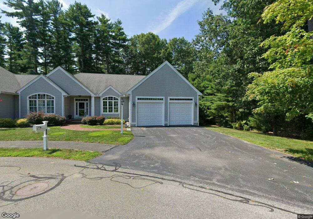
80 Samuel Curtis Way Marshfield, MA 02050
Estimated Value: $849,000 - $924,000
2
Beds
2
Baths
2,376
Sq Ft
$374/Sq Ft
Est. Value
About This Home
This home is located at 80 Samuel Curtis Way, Marshfield, MA 02050 and is currently estimated at $888,333, approximately $373 per square foot. 80 Samuel Curtis Way is a home located in Plymouth County with nearby schools including Martinson Elementary School, Furnace Brook Middle School, and Marshfield High School.
Ownership History
Date
Name
Owned For
Owner Type
Purchase Details
Closed on
Oct 20, 2022
Sold by
Rfm Rt and Masinda
Bought by
Marzelli Robert L and Marzelli Karen M
Current Estimated Value
Home Financials for this Owner
Home Financials are based on the most recent Mortgage that was taken out on this home.
Original Mortgage
$576,000
Outstanding Balance
$551,603
Interest Rate
5.89%
Mortgage Type
Purchase Money Mortgage
Estimated Equity
$336,730
Purchase Details
Closed on
Aug 1, 2013
Sold by
Locke Lucy A
Bought by
Rem Rt and Masinda
Create a Home Valuation Report for This Property
The Home Valuation Report is an in-depth analysis detailing your home's value as well as a comparison with similar homes in the area
Home Values in the Area
Average Home Value in this Area
Purchase History
| Date | Buyer | Sale Price | Title Company |
|---|---|---|---|
| Marzelli Robert L | $740,000 | None Available | |
| Rem Rt | $528,500 | -- | |
| Rem Rt | $528,500 | -- |
Source: Public Records
Mortgage History
| Date | Status | Borrower | Loan Amount |
|---|---|---|---|
| Open | Marzelli Robert L | $576,000 | |
| Previous Owner | Rem Rt | $417,000 | |
| Previous Owner | Rem Rt | $417,000 | |
| Previous Owner | Rem Rt | $505,350 |
Source: Public Records
Tax History
| Year | Tax Paid | Tax Assessment Tax Assessment Total Assessment is a certain percentage of the fair market value that is determined by local assessors to be the total taxable value of land and additions on the property. | Land | Improvement |
|---|---|---|---|---|
| 2025 | $7,822 | $790,100 | $0 | $790,100 |
| 2024 | $7,910 | $761,300 | $0 | $761,300 |
| 2023 | $8,923 | $757,400 | $0 | $757,400 |
| 2022 | $8,923 | $689,000 | $0 | $689,000 |
| 2021 | $7,636 | $578,900 | $0 | $578,900 |
| 2020 | $7,502 | $562,800 | $0 | $562,800 |
| 2019 | $7,530 | $562,800 | $0 | $562,800 |
| 2018 | $6,924 | $517,900 | $0 | $517,900 |
| 2017 | $7,219 | $526,200 | $0 | $526,200 |
| 2016 | $6,492 | $467,700 | $0 | $467,700 |
| 2015 | $6,898 | $519,000 | $0 | $519,000 |
| 2014 | $5,950 | $447,700 | $0 | $447,700 |
Source: Public Records
Map
Nearby Homes
- 60 Samuel Curtis Way
- 889 Old Main Street Extension
- 1155 Main St
- 29 Shepherd's Path
- 1 Valley Path
- 848 Plain St Unit 41
- 848 Plain St Unit 23
- 451 School St Unit 2-5
- 451 School St Unit 5-2
- 10 Royal Dane Dr Unit 85
- 5 Royal Dane Dr Unit 45
- 487 Main St
- 341 Furnace St
- 2 Proprietors Dr Unit 25
- 2 Proprietors Dr Unit 26
- 2 Proprietors Dr Unit 27
- 480 Pleasant St
- 97 Wrights Way
- 167 Planting Field Rd
- 3 Red Pony Path Unit 3
- 70 Samuel Curtis Way
- 80 Samuel Curtis Way Unit 80
- 50 Samuel Curtis Way
- 50 Samuel Curtis Way Unit 5
- 574 Forest St
- 100 Samuel Curtis Way
- 90 Samuel Curtis Way
- 100 Samuel Curtis Way Unit 100
- 595 Forest St
- 609 Forest St
- 0 Forest St
- 2 Samuel Curtis Way Unit 2
- 1 Samuel Curtis Way Unit 1
- 581 Forest St
- 20 Samuel Curtis Way
- 10 Samuel Curtis Way
- 20 Samuel Curtis Way Unit 2
- 40 Samuel Curtis Way
- 30 Samuel Curtis Way
- 562 Forest St
Your Personal Tour Guide
Ask me questions while you tour the home.