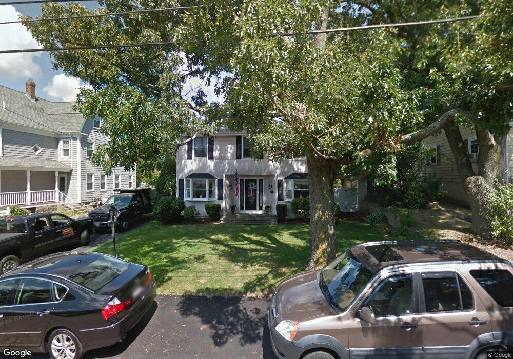
80 Wesson Ave Quincy, MA 02169
Estimated Value: $806,000 - $942,000
4
Beds
3
Baths
2,180
Sq Ft
$391/Sq Ft
Est. Value
About This Home
This home is located at 80 Wesson Ave, Quincy, MA 02169 and is currently estimated at $852,860, approximately $391 per square foot. 80 Wesson Ave is a home located in Norfolk County with nearby schools including South West Middle School, Lincoln-Hancock Community School, and Quincy High School.
Ownership History
Date
Name
Owned For
Owner Type
Purchase Details
Closed on
Nov 18, 2013
Sold by
Reggiannini Joseph P and Reggiannini Patricia M
Bought by
Reggiannini Ft
Current Estimated Value
Purchase Details
Closed on
Sep 3, 1980
Bought by
Reggiannini Joseph
Create a Home Valuation Report for This Property
The Home Valuation Report is an in-depth analysis detailing your home's value as well as a comparison with similar homes in the area
Purchase History
| Date | Buyer | Sale Price | Title Company |
|---|---|---|---|
| Reggiannini Ft | -- | -- | |
| Reggiannini Joseph | -- | -- |
Source: Public Records
Mortgage History
| Date | Status | Borrower | Loan Amount |
|---|---|---|---|
| Previous Owner | Reggiannini Joseph | $168,000 | |
| Previous Owner | Reggiannini Joseph | $90,000 | |
| Previous Owner | Reggiannini Joseph | $100,000 |
Source: Public Records
Tax History
| Year | Tax Paid | Tax Assessment Tax Assessment Total Assessment is a certain percentage of the fair market value that is determined by local assessors to be the total taxable value of land and additions on the property. | Land | Improvement |
|---|---|---|---|---|
| 2025 | $9,216 | $799,300 | $317,900 | $481,400 |
| 2024 | $8,735 | $775,100 | $303,100 | $472,000 |
| 2023 | $8,115 | $729,100 | $289,000 | $440,100 |
| 2022 | $7,829 | $653,500 | $232,300 | $421,200 |
| 2021 | $7,751 | $638,500 | $232,300 | $406,200 |
| 2020 | $7,622 | $613,200 | $232,300 | $380,900 |
| 2019 | $7,362 | $586,600 | $225,800 | $360,800 |
| 2018 | $7,412 | $555,600 | $209,500 | $346,100 |
| 2017 | $7,288 | $514,300 | $199,800 | $314,500 |
| 2016 | $6,814 | $474,500 | $182,200 | $292,300 |
| 2015 | $6,439 | $441,000 | $172,200 | $268,800 |
| 2014 | $6,154 | $414,100 | $167,700 | $246,400 |
Source: Public Records
Map
Nearby Homes
- 36 Village Dr
- 87 Village Dr
- 510 Willard St
- 9 Westford St
- 51 Branch St Unit 2
- 25 McDonald St
- 459 Willard St Unit 303
- 132 Centre St
- 21 Totman St Unit 308
- 21 Totman St Unit 205
- 21 Totman St Unit 404
- 21 Totman St Unit 309
- 21 Totman St Unit 203
- 21 Totman St Unit PH-406
- 21 Totman St Unit 301
- 21 Totman St Unit PH-405
- 21 Totman St Unit 407
- 57 Buckley St
- 211 Copeland St
- 14 Arthur Ave
Your Personal Tour Guide
Ask me questions while you tour the home.