Estimated payment $8,711/month
Highlights
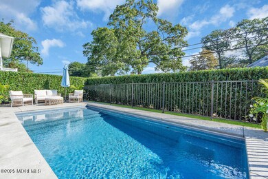
- In Ground Pool
- Wood Flooring
- Attic
- G Harold Antrim Elementary School Rated A-
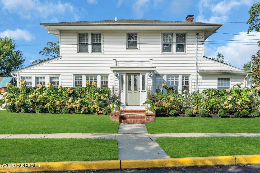
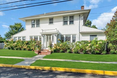
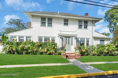
- Shore Colonial Architecture
- Bonus Room
About This Home
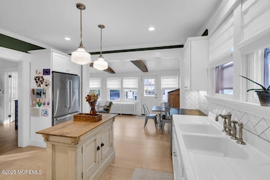
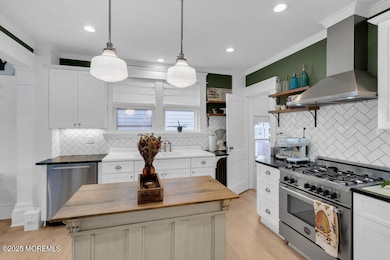
This is a Coming Soon and cannot be shown until 12/1/25. Welcome home to this timeless gem in the coveted Library Section of Point Pleasant Beach. This charming 3 Bedroom, 2 and a Half Bath property sits on a sunny corner lot just a block from downtown shops and restaurants. Filled with natural light, it features hardwood floors, solid wood doors, and a beautifully appointed kitchen. Enjoy a large living room with wood burning fireplace, and two bonus rooms on the first floor. A generous Primary Suite on the second floor, two additional bedrooms, a walk up attic, full unfinished basement, and detached garage round out the house. The fenced yard with in ground pool completes this lovingly preserved home, perfect for buyers looking to be in this beautiful and desirable area.
Home Details
Home Type
- Single Family
Est. Annual Taxes
- $9,478
Year Built
- Built in 1928
Lot Details
- 8,276 Sq Ft Lot
- Lot Dimensions are 58 x 140
- Fenced
- Corner Lot
Parking
- 2 Car Detached Garage
- Oversized Parking
- Parking Available
- Driveway
- On-Street Parking
Home Design
- Shore Colonial Architecture
- Shingle Roof
- Vinyl Siding
Interior Spaces
- 1,664 Sq Ft Home
- 2-Story Property
- Built-In Features
- Wood Burning Fireplace
- French Doors
- Bonus Room
- Basement Fills Entire Space Under The House
- Walkup Attic
Kitchen
- Eat-In Kitchen
- Stove
- Microwave
- Dishwasher
- Kitchen Island
Flooring
- Wood
- Concrete
- Ceramic Tile
Bedrooms and Bathrooms
- 3 Bedrooms
- Primary Bathroom is a Full Bathroom
- Primary Bathroom includes a Walk-In Shower
Laundry
- Dryer
- Washer
- Laundry Tub
Outdoor Features
- In Ground Pool
- Patio
Schools
- Antrim Elementary And Middle School
- Point Pleasant Beach High School
Utilities
- Zoned Heating and Cooling
- Heating System Uses Oil Above Ground
- Well
- Electric Water Heater
Community Details
- No Home Owners Association
Listing and Financial Details
- Exclusions: 3 Light Fixtures- Dining room, Landing of stairs, upstairs hallway
- Assessor Parcel Number 26-00200-01-00024
Map
Home Values in the Area
Average Home Value in this Area
Tax History
| Year | Tax Paid | Tax Assessment Tax Assessment Total Assessment is a certain percentage of the fair market value that is determined by local assessors to be the total taxable value of land and additions on the property. | Land | Improvement |
|---|---|---|---|---|
| 2025 | $9,478 | $551,700 | $341,000 | $210,700 |
| 2024 | $9,191 | $551,700 | $341,000 | $210,700 |
| 2023 | $8,501 | $525,100 | $341,000 | $184,100 |
| 2022 | $8,501 | $525,100 | $341,000 | $184,100 |
| 2021 | $8,312 | $525,100 | $341,000 | $184,100 |
| 2020 | $8,302 | $525,100 | $341,000 | $184,100 |
| 2019 | $8,186 | $525,100 | $341,000 | $184,100 |
| 2018 | $8,060 | $525,100 | $341,000 | $184,100 |
| 2017 | $7,934 | $525,100 | $341,000 | $184,100 |
| 2016 | $7,971 | $525,100 | $341,000 | $184,100 |
| 2015 | $7,908 | $525,100 | $341,000 | $184,100 |
| 2014 | $7,871 | $525,100 | $341,000 | $184,100 |
Purchase History
| Date | Type | Sale Price | Title Company |
|---|---|---|---|
| Deed | $500,000 | -- | |
| Interfamily Deed Transfer | -- | None Available |
Source: MOREMLS (Monmouth Ocean Regional REALTORS®)
MLS Number: 22535354
APN: 26-00200-01-00024
Disclaimer: Certain information contained herein is derived from information provided by parties other than Homes.com. All information provided is deemed reliable, but is not guaranteed to be accurate and should be independently verified.
![]() IDX information is provided exclusively for personal, non-commercial use, and may not be used for any purpose other than to identify prospective properties consumers may be interested in purchasing.
IDX information is provided exclusively for personal, non-commercial use, and may not be used for any purpose other than to identify prospective properties consumers may be interested in purchasing.
Information is deemed reliable but not guaranteed.
- 728 Arnold Ave
- 845 Arnold Ave Unit 3
- 606 Bay Ave Unit 2
- 807 Trenton Ave
- 842 Arnold Ave Unit 2
- 842 Arnold Ave Unit 3
- 326 Curtis Ave Unit Lot 27
- 607 Richmond Ave Unit 4
- 704 Forman Ave
- 325 Hawthorne Ave Unit 327
- 328 Curtis Ave Unit Lot 28
- 921 Arnold Ave
- 804 Clark St
- 303 Cooks Ln
- 503 Atlantic Ave
- 818 Sinclair Rd
- 204 Curtis Ave
- 109 Griffiths Ave
- 917 Route 88 Unit 5
- 201 Forman Ave
- 309 Lincoln Ave Unit WEEKLY
- 333 Hawthorne Ave
- 801 Atlantic Ave
- 865 Arnold Ave
- 816 Atlantic Ave Unit A
- 311 River Ave
- 506 Atlantic Ave
- 312 Saint Louis Ave
- 304 Arnold Ave
- 401 New Jersey Ave Unit 3
- 633 Manetta Dr N
- 1119 Wessie St
- 304 Atlantic Ave
- 305 Baltimore Ave
- 105 St Louis Ave
- 214 Atlantic Ave
- 127 Trenton Ave
- 101 Saint Louis Ave
- 100 Niblick St
- 305 Newark Ave
