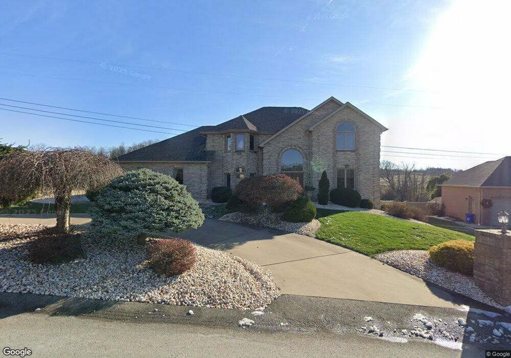
800 Rembrandt Cir Irwin, PA 15642
Hempfield Township NeighborhoodEstimated Value: $592,000 - $767,844
5
Beds
4
Baths
3,148
Sq Ft
$212/Sq Ft
Est. Value
About This Home
This home is located at 800 Rembrandt Cir, Irwin, PA 15642 and is currently estimated at $667,461, approximately $212 per square foot. 800 Rembrandt Cir is a home located in Westmoreland County with nearby schools including West Hempfield Elementary School, West Hempfield Middle School, and Hempfield Area Senior High School.
Ownership History
Date
Name
Owned For
Owner Type
Purchase Details
Closed on
Oct 8, 2010
Sold by
Svetz Michelle L
Bought by
Kociubinski Mark A
Current Estimated Value
Home Financials for this Owner
Home Financials are based on the most recent Mortgage that was taken out on this home.
Original Mortgage
$315,920
Outstanding Balance
$208,686
Interest Rate
4.37%
Mortgage Type
New Conventional
Estimated Equity
$458,775
Purchase Details
Closed on
Jan 18, 2008
Sold by
Svetz Michelle L
Bought by
Svetz Michelle L
Home Financials for this Owner
Home Financials are based on the most recent Mortgage that was taken out on this home.
Original Mortgage
$385,000
Interest Rate
6.18%
Mortgage Type
Stand Alone Refi Refinance Of Original Loan
Create a Home Valuation Report for This Property
The Home Valuation Report is an in-depth analysis detailing your home's value as well as a comparison with similar homes in the area
Home Values in the Area
Average Home Value in this Area
Purchase History
| Date | Buyer | Sale Price | Title Company |
|---|---|---|---|
| Kociubinski Mark A | $394,900 | None Available | |
| Svetz Michelle L | -- | None Available |
Source: Public Records
Mortgage History
| Date | Status | Borrower | Loan Amount |
|---|---|---|---|
| Open | Kociubinski Mark A | $315,920 | |
| Previous Owner | Svetz Michelle L | $385,000 |
Source: Public Records
Tax History Compared to Growth
Tax History
| Year | Tax Paid | Tax Assessment Tax Assessment Total Assessment is a certain percentage of the fair market value that is determined by local assessors to be the total taxable value of land and additions on the property. | Land | Improvement |
|---|---|---|---|---|
| 2025 | $7,596 | $62,140 | $11,620 | $50,520 |
| 2024 | $7,285 | $62,140 | $11,620 | $50,520 |
| 2023 | $6,708 | $62,140 | $11,620 | $50,520 |
| 2022 | $6,708 | $62,140 | $11,620 | $50,520 |
| 2021 | $6,708 | $62,140 | $11,620 | $50,520 |
| 2020 | $6,708 | $62,140 | $11,620 | $50,520 |
| 2019 | $6,677 | $62,140 | $11,620 | $50,520 |
| 2018 | $6,599 | $62,140 | $11,620 | $50,520 |
| 2017 | $6,446 | $62,140 | $11,620 | $50,520 |
| 2016 | $6,128 | $62,140 | $11,620 | $50,520 |
| 2015 | $6,128 | $62,140 | $11,620 | $50,520 |
| 2014 | $6,034 | $62,140 | $11,620 | $50,520 |
Source: Public Records
Map
Nearby Homes
- 1004 Cicero Dr
- 410 Lorenzo Ln
- 208 Robinhood Dr Unit 3
- 1627 Windsor Dr
- 513 Bucktown Rd
- 1722 Arona Rd
- 4045 Blue Willow St
- lot #42 Fern Rd
- 112 Friendship Ln
- 116 Williamsburg Place
- 105 Northumberland Dr
- 458 Wendel Rd
- 11 N Rolling Hills Ave
- 18 Dell Dr
- 4041 Second St
- 7814 U S 30
- 690 Elliot Dr
- 8044 Gladstone Dr
- 8005 Hayward St
- 247 Colleen Ln
- 802 Rembrandt Cir
- 718 Rembrandt Cir
- 721 Rembrandt Cir
- 719 Rembrandt Cir
- 804 Rembrandt Cir
- 805 Rembrandt Cir
- 715 Rembrandt Cir
- 714 Rembrandt Cir
- 73 Raphael Dr
- 806 Rembrandt Cir
- 713 Rembrandt Cir
- 74 Raphael Dr
- 74 Raphael Dr
- 902 Giovanni Ln
- 71 Raphael Dr
- 901 Giovanni Ln
- 711 Rembrandt Cir
- 808 Rembrandt Cir
- 809 Rembrandt Cir
- 712 Rembrandt Cir