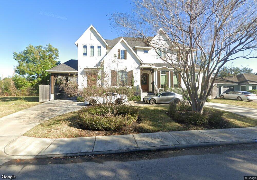
8007 Lorrie Dr Houston, TX 77025
Braeswood Place NeighborhoodEstimated Value: $1,044,000 - $1,269,926
4
Beds
5
Baths
4,249
Sq Ft
$274/Sq Ft
Est. Value
About This Home
This home is located at 8007 Lorrie Dr, Houston, TX 77025 and is currently estimated at $1,163,232, approximately $273 per square foot. 8007 Lorrie Dr is a home located in Harris County with nearby schools including Longfellow Elementary School, Pershing Middle School, and Bellaire High School.
Ownership History
Date
Name
Owned For
Owner Type
Purchase Details
Closed on
Apr 1, 2017
Sold by
Gkb Realty Investments Ltd
Bought by
Slivernsky Bradley W and Slivernsky Jennifer B
Current Estimated Value
Purchase Details
Closed on
Jul 3, 1997
Sold by
Goodeaux Manford and Goodeaux Dorothy
Bought by
Brooks Geneva Kirk
Purchase Details
Closed on
Feb 27, 1997
Sold by
Trancoso Tomas R and Trancoso Patricia A
Bought by
Brooks Geneva Kirk
Purchase Details
Closed on
Sep 23, 1996
Sold by
Brooks Geneva Kirk
Bought by
Romero Victor
Purchase Details
Closed on
Sep 3, 1996
Sold by
Vega J Guadalupe
Bought by
Brooks Geneva Kirk
Purchase Details
Closed on
Nov 8, 1993
Sold by
Vancleave Steve
Bought by
Brooks Geneva Kirk
Purchase Details
Closed on
Oct 6, 1993
Sold by
Collette Ernest J and Collette Myra J
Bought by
Brooks Geneva Kirk
Create a Home Valuation Report for This Property
The Home Valuation Report is an in-depth analysis detailing your home's value as well as a comparison with similar homes in the area
Home Values in the Area
Average Home Value in this Area
Purchase History
| Date | Buyer | Sale Price | Title Company |
|---|---|---|---|
| Slivernsky Bradley W | -- | None Available | |
| Brooks Geneva Kirk | -- | -- | |
| Brooks Geneva Kirk | -- | -- | |
| Romero Victor | -- | -- | |
| Brooks Geneva Kirk | -- | -- | |
| Brooks Geneva Kirk | -- | -- | |
| Brooks Geneva Kirk | -- | -- |
Source: Public Records
Tax History Compared to Growth
Tax History
| Year | Tax Paid | Tax Assessment Tax Assessment Total Assessment is a certain percentage of the fair market value that is determined by local assessors to be the total taxable value of land and additions on the property. | Land | Improvement |
|---|---|---|---|---|
| 2025 | $19,478 | $1,198,296 | $354,535 | $843,761 |
| 2024 | $19,478 | $1,213,429 | $354,535 | $858,894 |
| 2023 | $19,478 | $1,125,025 | $329,800 | $795,225 |
| 2022 | $23,225 | $1,104,555 | $329,800 | $774,755 |
| 2021 | $22,348 | $958,870 | $329,800 | $629,070 |
| 2020 | $23,766 | $981,434 | $329,800 | $651,634 |
| 2019 | $14,190 | $560,768 | $329,800 | $230,968 |
| 2018 | $9,659 | $381,700 | $381,600 | $100 |
| 2017 | $9,652 | $381,700 | $381,600 | $100 |
| 2016 | $9,806 | $387,806 | $387,515 | $291 |
| 2015 | $8,260 | $387,806 | $387,515 | $291 |
| 2014 | $8,260 | $321,313 | $313,310 | $8,003 |
Source: Public Records
Map
Nearby Homes
- 8020 Braesmain Dr Unit 1710
- 2601 S Braeswood Blvd Unit 706
- 2601 S Braeswood Blvd Unit 105
- 2601 S Braeswood Blvd Unit 605
- 2601 S Braeswood Blvd Unit 1403
- 2601 S Braeswood Blvd Unit 1005
- 8014 Serenity Ct
- 3028 Winslow St
- 7575 Kirby Dr Unit 1211
- 7575 Kirby Dr Unit 2204
- 7575 Kirby Dr Unit 3202
- 7575 Kirby Dr Unit 2202
- 7575 Kirby Dr Unit 1209
- 7575 Kirby Dr Unit 1303
- 7575 Kirby Dr Unit 1202
- 3026 Fairhope St
- 7499 Brompton St Unit 7499
- 2400 N Braeswood Blvd Unit 227
- 2400 N Braeswood Blvd Unit 129
- 2400 N Braeswood Blvd Unit 314
- 8011 Lorrie Dr
- 2731 S Braeswood Blvd
- 8015 Lorrie Dr
- 2802 Conway St
- 2803 S Braeswood Blvd
- 8020 Braesmain Dr Unit 1605
- 8020 Braesmain Dr Unit 1603
- 8020 Braesmain Dr
- 8020 Braesmain Dr
- 8020 Braesmain Dr
- 8020 Braesmain Dr
- 8020 Braesmain Dr
- 8020 Braesmain Dr
- 8020 Braesmain Dr
- 8020 Braesmain Dr
- 8020 Braesmain Dr
- 8020 Braesmain Dr
- 8020 Braesmain Dr
- 8020 Braesmain Dr
- 8020 Braesmain Dr