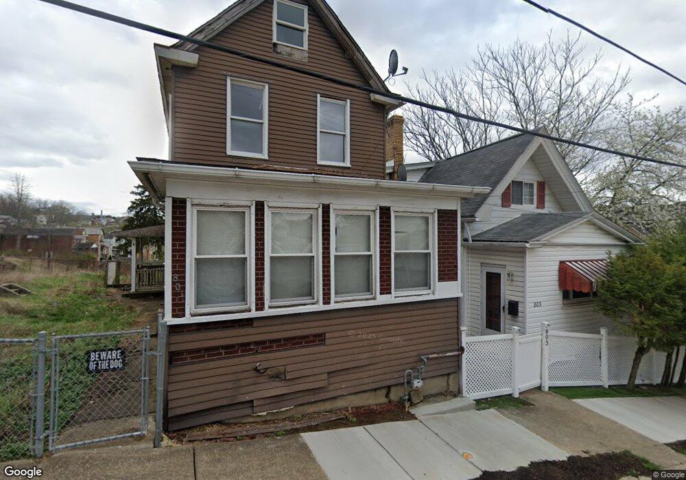
801 11th St Mc Kees Rocks, PA 15136
Stowe Township NeighborhoodEstimated Value: $48,000 - $117,000
2
Beds
1
Bath
1,412
Sq Ft
$56/Sq Ft
Est. Value
About This Home
This home is located at 801 11th St, Mc Kees Rocks, PA 15136 and is currently estimated at $78,880, approximately $55 per square foot. 801 11th St is a home located in Allegheny County with nearby schools including Sto-Rox Upper Elementary School, Sto-Rox Primary Center, and Sto-Rox Junior/Senior High School.
Ownership History
Date
Name
Owned For
Owner Type
Purchase Details
Closed on
Jun 2, 2005
Sold by
Kunkle Craig
Bought by
Haun Rayme B
Current Estimated Value
Home Financials for this Owner
Home Financials are based on the most recent Mortgage that was taken out on this home.
Original Mortgage
$49,000
Outstanding Balance
$25,696
Interest Rate
5.83%
Mortgage Type
New Conventional
Estimated Equity
$53,184
Purchase Details
Closed on
Jul 16, 2001
Sold by
Community Investment Group Ltd
Bought by
Powell Steffany D
Purchase Details
Closed on
Mar 29, 2001
Sold by
Smith Shawn
Bought by
Community Investment Group Ltd
Purchase Details
Closed on
Apr 25, 2000
Sold by
Gill Catherine S
Bought by
Smith Shawn
Create a Home Valuation Report for This Property
The Home Valuation Report is an in-depth analysis detailing your home's value as well as a comparison with similar homes in the area
Home Values in the Area
Average Home Value in this Area
Purchase History
| Date | Buyer | Sale Price | Title Company |
|---|---|---|---|
| Haun Rayme B | $47,000 | -- | |
| Powell Steffany D | $24,586 | -- | |
| Community Investment Group Ltd | -- | -- | |
| Smith Shawn | $13,600 | -- |
Source: Public Records
Mortgage History
| Date | Status | Borrower | Loan Amount |
|---|---|---|---|
| Open | Haun Rayme B | $49,000 |
Source: Public Records
Tax History Compared to Growth
Tax History
| Year | Tax Paid | Tax Assessment Tax Assessment Total Assessment is a certain percentage of the fair market value that is determined by local assessors to be the total taxable value of land and additions on the property. | Land | Improvement |
|---|---|---|---|---|
| 2025 | $398 | $9,200 | $9,200 | -- |
| 2024 | $398 | $9,200 | $9,200 | -- |
| 2023 | $382 | $9,200 | $9,200 | $0 |
| 2022 | $370 | $9,200 | $9,200 | $0 |
| 2021 | $44 | $9,200 | $9,200 | $0 |
| 2020 | $362 | $9,200 | $9,200 | $0 |
| 2019 | $362 | $9,200 | $9,200 | $0 |
| 2018 | $44 | $9,200 | $9,200 | $0 |
| 2017 | $353 | $9,200 | $9,200 | $0 |
| 2016 | $44 | $9,200 | $9,200 | $0 |
| 2015 | $44 | $9,200 | $9,200 | $0 |
| 2014 | $353 | $9,200 | $9,200 | $0 |
Source: Public Records
Map
Nearby Homes
- 809 11th St
- 802 10th St
- 932 Ridge Ave
- 810 10th St
- 813 10th St
- 815 10th St
- 1212 Woodward Ave
- 837 Benwood Ave
- 813 8th St
- 908 Russellwood Ave
- 810 Woodward Ave
- 815 Broadway Ave
- 1406 Broadway Ave
- 1408 Broadway Ave
- 1131 13th St
- 1140 12th St
- 124 Pleasant Ridge Rd
- 713 Russellwood Ave
- 1144 1/2 Race St
- 705 Broadway Ave