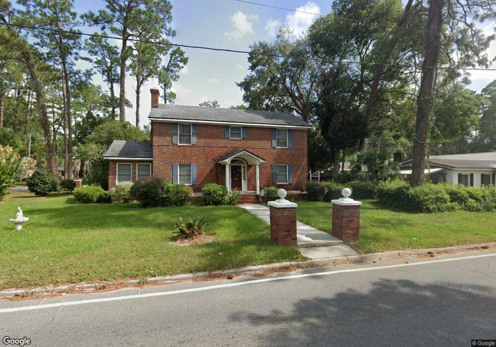
801 Ava St Waycross, GA 31501
Estimated Value: $206,000 - $309,000
3
Beds
3
Baths
3,084
Sq Ft
$86/Sq Ft
Est. Value
About This Home
This home is located at 801 Ava St, Waycross, GA 31501 and is currently estimated at $266,537, approximately $86 per square foot. 801 Ava St is a home located in Ware County with nearby schools including Williams Heights Elementary School, Waycross Middle School, and Ware County High School.
Ownership History
Date
Name
Owned For
Owner Type
Purchase Details
Closed on
Dec 31, 2012
Sold by
Dobson Patricia L
Bought by
Dobson Patricia L and Johnson Jesse T
Current Estimated Value
Purchase Details
Closed on
Mar 16, 2001
Sold by
Adams James Dennis
Bought by
Dobson Patricia L
Purchase Details
Closed on
Sep 6, 1986
Create a Home Valuation Report for This Property
The Home Valuation Report is an in-depth analysis detailing your home's value as well as a comparison with similar homes in the area
Home Values in the Area
Average Home Value in this Area
Purchase History
| Date | Buyer | Sale Price | Title Company |
|---|---|---|---|
| Dobson Patricia L | -- | -- | |
| Dobson Patricia L | $139,900 | -- | |
| -- | $60,000 | -- |
Source: Public Records
Tax History Compared to Growth
Tax History
| Year | Tax Paid | Tax Assessment Tax Assessment Total Assessment is a certain percentage of the fair market value that is determined by local assessors to be the total taxable value of land and additions on the property. | Land | Improvement |
|---|---|---|---|---|
| 2024 | $3,340 | $144,292 | $5,440 | $138,852 |
| 2023 | $3,182 | $115,346 | $3,679 | $111,667 |
| 2022 | $3,505 | $115,346 | $3,679 | $111,667 |
| 2021 | $3,469 | $95,459 | $3,679 | $91,780 |
| 2020 | $3,338 | $82,109 | $3,679 | $78,430 |
| 2019 | $3,353 | $79,328 | $3,679 | $75,649 |
| 2018 | $3,416 | $76,547 | $3,679 | $72,868 |
| 2017 | $2,873 | $76,547 | $3,679 | $72,868 |
| 2016 | $2,873 | $76,547 | $3,679 | $72,868 |
| 2015 | $2,893 | $76,546 | $3,679 | $72,868 |
| 2014 | $2,889 | $76,547 | $3,679 | $72,868 |
| 2013 | -- | $80,683 | $3,679 | $77,004 |
Source: Public Records
Map
Nearby Homes
- 506 Magnolia Dr
- 808 Satilla Blvd
- 415 Dewey St
- 502 Dewey St
- 0 Goodwin St
- 511 Richmond Ave
- 1101 Cherokee Dr
- 924 Highsmith St
- 807 College St
- 713 Magnolia Dr
- 903 Atlantic Ave
- 0 Saint Marys Dr Unit (TRACT 2 0.25 ACRES)
- 707 Euclid Ave
- 1405 Grove Ave
- 1100 Atlantic Ave
- 301 Riverside Dr
- 907 Euclid Ave
- 1205 Dean Dr
- 1701 Satilla Blvd
- 310 Butler St