
Seller's Agent in 2026
Lisa DiZio
RE/MAX
(215) 450-9525
9 in this area
22 Total Sales

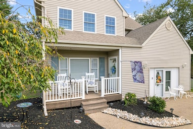
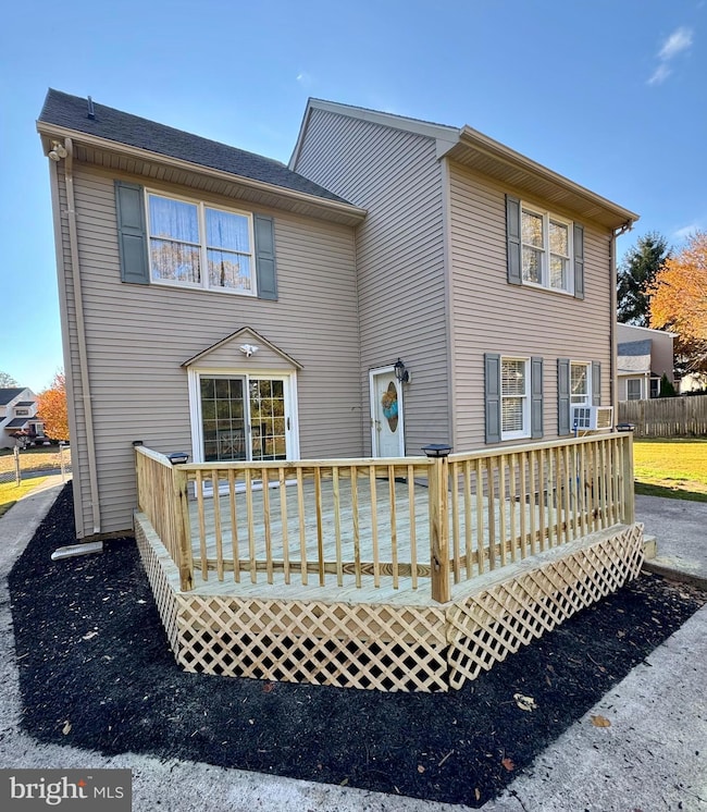
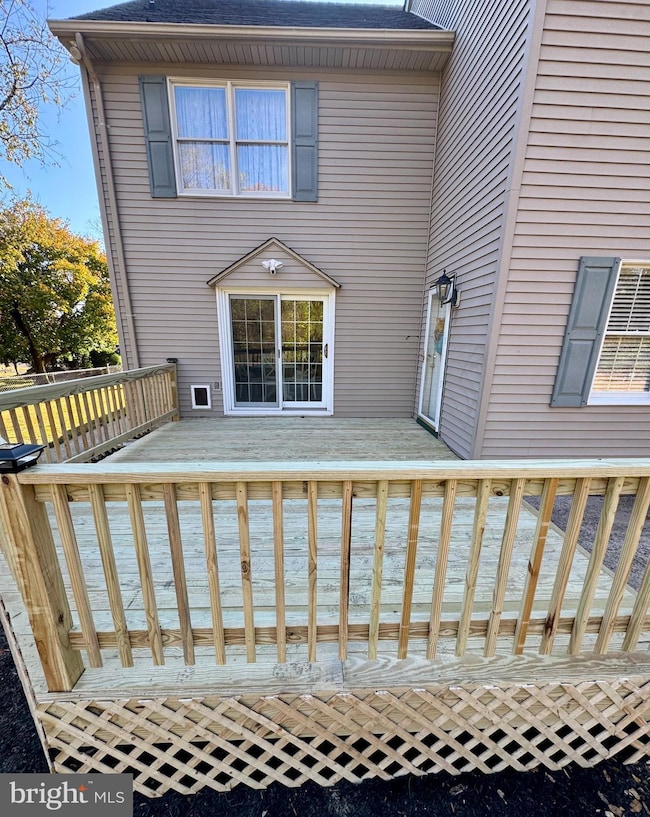
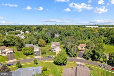
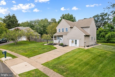
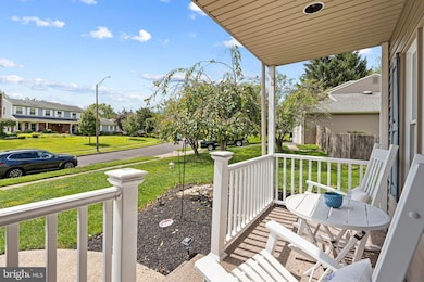
Welcome to the ONE you have been waiting for Featuring a NEW DECK Just Installed! Wonderful Move-In Ready and Perfect for making your own Home in Bucks County Estates. Inviting Front Porch to Sit back and take in the Scenery leads you into the main level featuring NEW Plank Flooring, NEW Crown Molding, First Floor Blinds and Fresh Paint in a neutral Palette. Spacious Light and Airy Living room with Ceiling Fan and Coat Closet. Full size Dining room for large Family Gatherings with Chair Rail molding Atrium door to the outdoors just steps steps off the Eat-In Kitchen offering updated Cabinets, Tile Backsplash, Corian Countertops, Stainless Steel Appliances, Radius Window and Glass Sliders to back Deck. Family room formally the Oversized Garage Remodeled with Ceiling fan, window and door can easily be converted back. Convenient Updated Hall Bath. Main Floor Laundry with Washer and Dryer. Second floor features the primary Suite boasting Cathedral Ceiling, Ceiling Fan and Spacious Bath featuring Soaking Tub, Stall Shower and Linen Closet. Two other generous size bedrooms and Updated Hall Bath complete the second floor. Third level features a Loft Bedroom and Storage room. Private Fenced Backyard features a Deck and Patio . Also their is an Underground Electrical Feeder to a Electrical Conduit with cable if you were interested in adding an outdoor Structure in the Backyard. A home that has been loved and enjoyed, ready for its next Chapter. Convenient location with so much to offer!
Last Agent to Sell the Property
(215) 245-2100 lisasells@comcast.net RE/MAX Realty Services-Bensalem Brokerage Phone: 2152452100 License #RS250572 Listed on: 08/28/2025
Last Buyer's Agent
(215) 245-2100 lisasells@comcast.net RE/MAX Realty Services-Bensalem Brokerage Phone: 2152452100 License #RS250572 Listed on: 08/28/2025
| Date | Type | Sale Price | Title Company |
|---|---|---|---|
| Deed | $550,000 | First Platinum Abstract | |
| Deed | $149,900 | -- | |
| Quit Claim Deed | $800 | -- |
| Date | Status | Loan Amount | Loan Type |
|---|---|---|---|
| Open | $540,038 | FHA | |
| Previous Owner | $134,900 | No Value Available |
| Date | Event | Price | List to Sale | Price per Sq Ft |
|---|---|---|---|---|
| 01/28/2026 01/28/26 | Sold | $550,000 | -6.0% | $202 / Sq Ft |
| 12/16/2025 12/16/25 | Pending | -- | -- | -- |
| 11/05/2025 11/05/25 | Price Changed | $584,900 | -0.8% | $215 / Sq Ft |
| 10/06/2025 10/06/25 | Price Changed | $589,900 | -1.7% | $217 / Sq Ft |
| 09/08/2025 09/08/25 | Price Changed | $599,900 | -3.1% | $220 / Sq Ft |
| 08/28/2025 08/28/25 | For Sale | $619,000 | -- | $227 / Sq Ft |
| Year | Tax Paid | Tax Assessment Tax Assessment Total Assessment is a certain percentage of the fair market value that is determined by local assessors to be the total taxable value of land and additions on the property. | Land | Improvement |
|---|---|---|---|---|
| 2025 | $8,208 | $37,600 | $8,840 | $28,760 |
| 2024 | $8,208 | $37,600 | $8,840 | $28,760 |
| 2023 | $7,976 | $37,600 | $8,840 | $28,760 |
| 2022 | $7,930 | $37,600 | $8,840 | $28,760 |
| 2021 | $7,930 | $37,600 | $8,840 | $28,760 |
| 2020 | $7,850 | $37,600 | $8,840 | $28,760 |
| 2019 | $7,675 | $37,600 | $8,840 | $28,760 |
| 2018 | $7,497 | $37,600 | $8,840 | $28,760 |
| 2017 | $7,450 | $37,600 | $8,840 | $28,760 |
| 2016 | $7,450 | $37,600 | $8,840 | $28,760 |
| 2015 | -- | $37,600 | $8,840 | $28,760 |
| 2014 | -- | $37,600 | $8,840 | $28,760 |
Seller's Agent in 2026
Lisa DiZio
RE/MAX
(215) 450-9525
9 in this area
22 Total Sales
Source: Bright MLS
MLS Number: PABU2103832
APN: 02-078-122
Disclaimer: Certain information contained herein is derived from information provided by parties other than Homes.com. All information provided is deemed reliable, but is not guaranteed to be accurate and should be independently verified.
![]() The data relating to real estate for sale on this website appears in part through the BRIGHT Internet Data Exchange program, a voluntary cooperative exchange of property listing data between licensed real estate brokerage firms, and is provided by BRIGHT through a licensing agreement.
The data relating to real estate for sale on this website appears in part through the BRIGHT Internet Data Exchange program, a voluntary cooperative exchange of property listing data between licensed real estate brokerage firms, and is provided by BRIGHT through a licensing agreement.
Listing information is from various brokers who participate in the Bright MLS IDX program and not all listings may be visible on the site.
The property information being provided on or through the website is for the personal, non-commercial use of consumers and such information may not be used for any purpose other than to identify prospective properties consumers may be interested in purchasing.
Some properties which appear for sale on the website may no longer be available because they are for instance, under contract, sold or are no longer being offered for sale.
Property information displayed is deemed reliable but is not guaranteed.
Copyright 2026 Bright MLS, Inc.
Ask me questions while you tour the home.