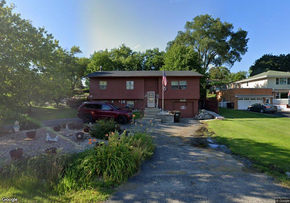
801 Sheridan Dr Wauconda, IL 60084
Estimated Value: $277,855 - $367,000
4
Beds
2
Baths
1,184
Sq Ft
$271/Sq Ft
Est. Value
About This Home
This home is located at 801 Sheridan Dr, Wauconda, IL 60084 and is currently estimated at $320,964, approximately $271 per square foot. 801 Sheridan Dr is a home located in Lake County with nearby schools including Wauconda Grade School, Wauconda Middle School, and Wauconda High School.
Ownership History
Date
Name
Owned For
Owner Type
Purchase Details
Closed on
May 27, 2005
Sold by
Pedersen Pamela J
Bought by
Ravenna Paul and Vilaro Judy
Current Estimated Value
Home Financials for this Owner
Home Financials are based on the most recent Mortgage that was taken out on this home.
Original Mortgage
$174,400
Interest Rate
5.69%
Mortgage Type
Purchase Money Mortgage
Purchase Details
Closed on
Feb 20, 1996
Sold by
Pedersen Pamela J and Clark Pamela J
Bought by
Pedersen Pamela J
Create a Home Valuation Report for This Property
The Home Valuation Report is an in-depth analysis detailing your home's value as well as a comparison with similar homes in the area
Home Values in the Area
Average Home Value in this Area
Purchase History
| Date | Buyer | Sale Price | Title Company |
|---|---|---|---|
| Ravenna Paul | $218,000 | Ticor | |
| Pedersen Pamela J | -- | Chicago Title Insurance Co |
Source: Public Records
Mortgage History
| Date | Status | Borrower | Loan Amount |
|---|---|---|---|
| Previous Owner | Ravenna Paul | $174,400 |
Source: Public Records
Tax History Compared to Growth
Tax History
| Year | Tax Paid | Tax Assessment Tax Assessment Total Assessment is a certain percentage of the fair market value that is determined by local assessors to be the total taxable value of land and additions on the property. | Land | Improvement |
|---|---|---|---|---|
| 2024 | $6,721 | $83,581 | $16,696 | $66,885 |
| 2023 | $6,673 | $76,399 | $15,261 | $61,138 |
| 2022 | $6,673 | $67,155 | $19,460 | $47,695 |
| 2021 | $6,138 | $63,456 | $18,388 | $45,068 |
| 2020 | $5,922 | $60,481 | $17,526 | $42,955 |
| 2019 | $5,243 | $57,160 | $16,564 | $40,596 |
| 2018 | $5,473 | $53,615 | $19,642 | $33,973 |
| 2017 | $5,467 | $52,995 | $19,415 | $33,580 |
| 2016 | $5,121 | $50,184 | $18,385 | $31,799 |
| 2015 | $4,792 | $46,070 | $16,878 | $29,192 |
| 2014 | $5,729 | $50,429 | $18,953 | $31,476 |
| 2012 | $5,592 | $55,064 | $18,134 | $36,930 |
Source: Public Records
Map
Nearby Homes
- 0 Bonner Rd
- 1260 Water Stone Cir
- 701 Lake Shore Dr
- 28855 N Garland Rd
- 28177 N Garland Rd
- 26049 N Il Route 59
- 29564 N Garland Rd
- 419 Hill St Unit 2805
- 302 Stillwater Ct Unit 1702
- 303 Stillwater Ct Unit 1106
- 309 Stillwater Ct Unit 1101
- 315 Hill St Unit A
- 136 Parkview Dr Unit 5136
- 26241 W Bonner Rd
- 325 Sundown Ct Unit B
- 225 Regency Ct Unit A
- 310 Sundown Ct Unit E
- 235 Regency Ct Unit B
- 240 Regency Ct
- 450 N Main St Unit S307A
- 1103 Adams St
- 1104 Monroe St
- 1103 Adams Ave
- 1105 Adams St
- 1101 Monroe St
- 1105 Monroe St
- 804 Sheridan Dr
- 1110 Monroe St
- 1107 Monroe St
- 718 Sheridan Dr
- 810 Sheridan Dr
- 810 Sheridan Dr
- 1109 Adams St
- 1112 Monroe St
- 1018 Monroe St
- 1109 Monroe St
- 1023 Monroe Ave
- 713 Sheridan Dr
- 1111 Adams St
- 1111 Adams St