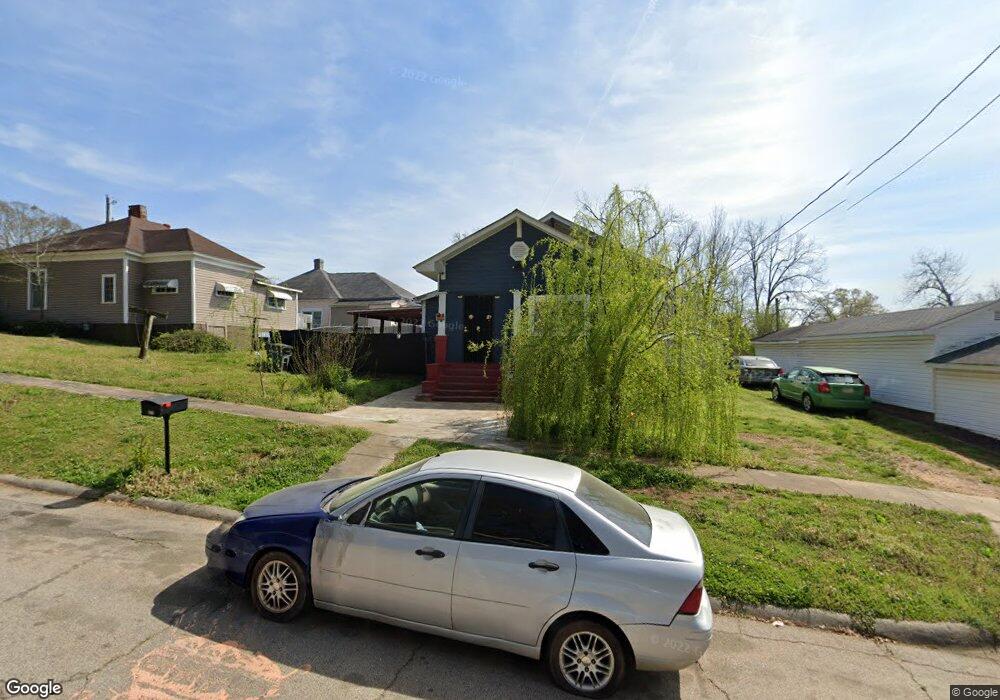
801 Swanson St Lagrange, GA 30240
Estimated Value: $66,000 - $182,000
3
Beds
1
Bath
1,324
Sq Ft
$87/Sq Ft
Est. Value
About This Home
This home is located at 801 Swanson St, Lagrange, GA 30240 and is currently estimated at $115,099, approximately $86 per square foot. 801 Swanson St is a home located in Troup County with nearby schools including Berta Weathersbee Elementary School, Whitesville Road Elementary School, and Rosemont Elementary School.
Ownership History
Date
Name
Owned For
Owner Type
Purchase Details
Closed on
Oct 14, 1998
Sold by
Janell Nixon
Bought by
Nixon Steven D
Current Estimated Value
Purchase Details
Closed on
Mar 16, 1996
Sold by
Velma Waters Wilson
Bought by
Janell Nixon
Purchase Details
Closed on
Mar 15, 1996
Sold by
Willie Waters
Bought by
Velma Waters Wilson
Purchase Details
Closed on
Jan 1, 1966
Sold by
Ida Worthy
Bought by
Willie Waters
Create a Home Valuation Report for This Property
The Home Valuation Report is an in-depth analysis detailing your home's value as well as a comparison with similar homes in the area
Home Values in the Area
Average Home Value in this Area
Purchase History
| Date | Buyer | Sale Price | Title Company |
|---|---|---|---|
| Nixon Steven D | $15,000 | -- | |
| Janell Nixon | -- | -- | |
| Velma Waters Wilson | -- | -- | |
| Willie Waters | -- | -- |
Source: Public Records
Tax History Compared to Growth
Tax History
| Year | Tax Paid | Tax Assessment Tax Assessment Total Assessment is a certain percentage of the fair market value that is determined by local assessors to be the total taxable value of land and additions on the property. | Land | Improvement |
|---|---|---|---|---|
| 2024 | $706 | $27,864 | $1,800 | $26,064 |
| 2023 | $614 | $24,516 | $1,800 | $22,716 |
| 2022 | $583 | $22,876 | $1,800 | $21,076 |
| 2021 | $494 | $18,356 | $1,800 | $16,556 |
| 2020 | $494 | $18,356 | $1,800 | $16,556 |
| 2019 | $544 | $18,036 | $1,800 | $16,236 |
| 2018 | $538 | $17,844 | $1,848 | $15,996 |
| 2017 | $538 | $17,844 | $1,848 | $15,996 |
| 2016 | $531 | $17,612 | $1,848 | $15,764 |
| 2015 | $532 | $17,612 | $1,848 | $15,764 |
| 2014 | $505 | $16,697 | $1,848 | $14,849 |
| 2013 | -- | $17,588 | $1,848 | $15,740 |
Source: Public Records
Map
Nearby Homes
- 900 B N Pkwy
- 1311 Juniper St
- 1205 Park Ave
- 1302 Murphy Ave
- 1300 Murphy Ave
- 1808 Murphy Ave
- 1304 Forrest Ave
- 1402 Forrest Ave
- 1301 Polk St
- 606 Poplar St
- 812 Elm St
- 914 Todd St
- 1186 Lindsey St
- 701 Jefferson St
- 612 S Lee St
- 109 Garfield St
- 517 Jefferson St
- W W Crovat St
- 1191 Whitesville St
- 1201 Whitesville St