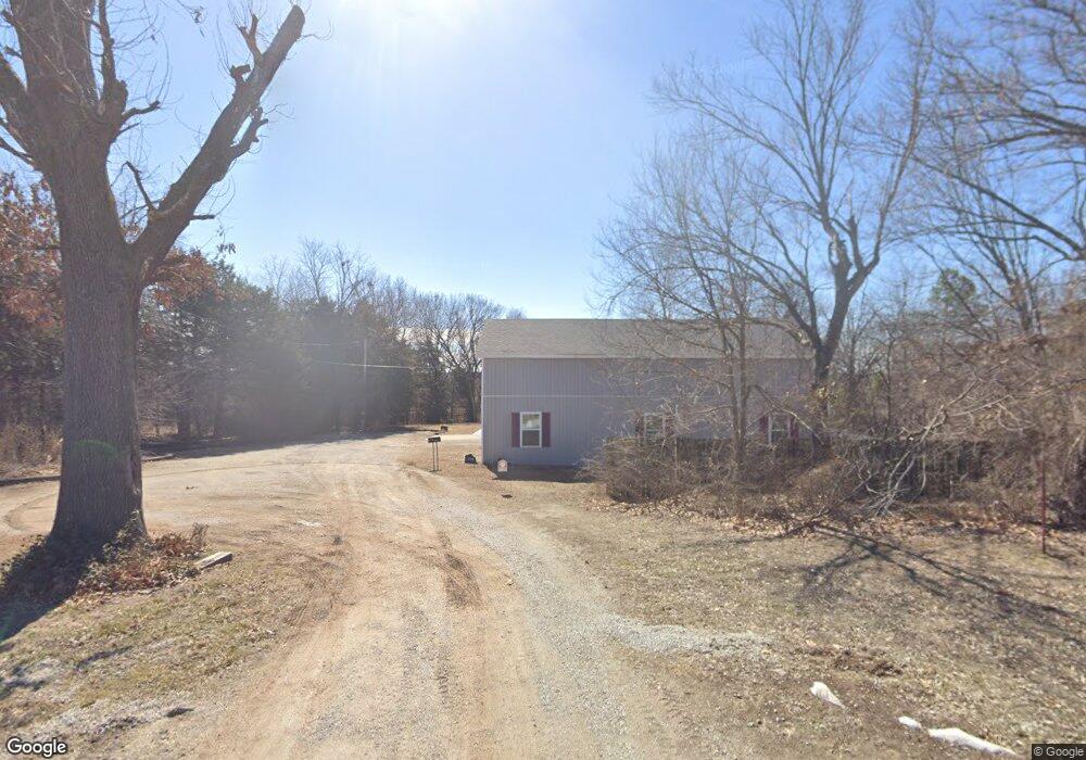
802 Hayes Ave Carl Junction, MO 64834
Estimated Value: $352,000 - $431,000
5
Beds
3
Baths
3,750
Sq Ft
$106/Sq Ft
Est. Value
About This Home
This home is located at 802 Hayes Ave, Carl Junction, MO 64834 and is currently estimated at $397,399, approximately $105 per square foot. 802 Hayes Ave is a home located in Jasper County with nearby schools including Carl Junction Primary School (K-1), Carl Junction Intermediate School, and Carl Junction Primary School (2-3).
Ownership History
Date
Name
Owned For
Owner Type
Purchase Details
Closed on
Dec 6, 2021
Sold by
Ohanahan Michael J and Ohanahan Lisa A
Bought by
Florence Michael V and Florence Lynne S
Current Estimated Value
Home Financials for this Owner
Home Financials are based on the most recent Mortgage that was taken out on this home.
Original Mortgage
$236,000
Outstanding Balance
$217,512
Interest Rate
3.09%
Mortgage Type
Stand Alone Refi Refinance Of Original Loan
Estimated Equity
$179,887
Purchase Details
Closed on
Oct 31, 2020
Sold by
Ohanahan Michael John and Ohanahan Lisa Ann
Bought by
Ohanahan Family Living Trust and Ohanahan
Home Financials for this Owner
Home Financials are based on the most recent Mortgage that was taken out on this home.
Original Mortgage
$140,000
Interest Rate
2.8%
Mortgage Type
Stand Alone Refi Refinance Of Original Loan
Purchase Details
Closed on
Jul 13, 2019
Sold by
Ohanahan Michael J and Ohanahan Lisa A
Bought by
Ohanahan Ft
Home Financials for this Owner
Home Financials are based on the most recent Mortgage that was taken out on this home.
Original Mortgage
$175,760
Interest Rate
3.82%
Mortgage Type
New Conventional
Purchase Details
Closed on
Jul 11, 2016
Sold by
Hanahan Michael J O and Hanahan Lisa O
Bought by
Hanahan Michael John O and Hanahan Lisa Ann O
Purchase Details
Closed on
Apr 1, 2009
Sold by
Federal Home Loan Mortgage Corporation
Bought by
Ohanahan Michael J and Ohanahan Lisa
Home Financials for this Owner
Home Financials are based on the most recent Mortgage that was taken out on this home.
Original Mortgage
$115,700
Interest Rate
4.76%
Mortgage Type
Unknown
Purchase Details
Closed on
Feb 5, 2009
Sold by
Hayes Carolyn and Hayes Walter E
Bought by
Federal Home Loan Mortgage Corp
Home Financials for this Owner
Home Financials are based on the most recent Mortgage that was taken out on this home.
Original Mortgage
$115,700
Interest Rate
4.76%
Mortgage Type
Unknown
Create a Home Valuation Report for This Property
The Home Valuation Report is an in-depth analysis detailing your home's value as well as a comparison with similar homes in the area
Home Values in the Area
Average Home Value in this Area
Purchase History
| Date | Buyer | Sale Price | Title Company |
|---|---|---|---|
| Florence Michael V | -- | None Available | |
| Ohanahan Family Living Trust | -- | None Listed On Document | |
| Ohanahan Family Living Trust | -- | None Listed On Document | |
| Ohanahan Michael J | -- | None Available | |
| Ohanahan Michael John | -- | None Listed On Document | |
| Ohanahan Ft | -- | -- | |
| Ohanahan Michael J | -- | -- | |
| Hanahan Michael John O | -- | None Available | |
| Ohanahan Michael J | -- | Fatco | |
| Federal Home Loan Mortgage Corp | $123,763 | St |
Source: Public Records
Mortgage History
| Date | Status | Borrower | Loan Amount |
|---|---|---|---|
| Open | Florence Michael V | $236,000 | |
| Previous Owner | Ohanahan Michael John | $140,000 | |
| Previous Owner | Ohanahan Michael J | $175,760 | |
| Previous Owner | Ohanahan Michael J | $115,700 |
Source: Public Records
Tax History Compared to Growth
Tax History
| Year | Tax Paid | Tax Assessment Tax Assessment Total Assessment is a certain percentage of the fair market value that is determined by local assessors to be the total taxable value of land and additions on the property. | Land | Improvement |
|---|---|---|---|---|
| 2025 | $2,279 | $49,420 | $2,630 | $46,790 |
| 2024 | $2,277 | $45,000 | $2,630 | $42,370 |
| 2023 | $2,277 | $45,000 | $2,630 | $42,370 |
| 2022 | $1,455 | $28,560 | $2,630 | $25,930 |
| 2021 | $1,446 | $28,560 | $2,630 | $25,930 |
| 2020 | $1,353 | $26,260 | $2,630 | $23,630 |
| 2019 | $1,284 | $26,260 | $2,630 | $23,630 |
| 2018 | $1,348 | $27,620 | $0 | $0 |
| 2017 | $1,351 | $27,620 | $0 | $0 |
| 2016 | $1,370 | $28,260 | $0 | $0 |
| 2015 | $1,341 | $28,260 | $0 | $0 |
| 2014 | $1,341 | $28,260 | $0 | $0 |
Source: Public Records
Map
Nearby Homes
- 802 Aberdeen Ave
- 505 W Walton Ave
- 408 W Walton Ave
- 409 W Gault St
- 409 Gault St
- 114 W Walton Ave
- TBD S Roney St
- 311 S Roney St
- 106 S Roney St
- 819 Delaney Dr
- 815 Delaney Dr
- 205 Allen St
- Tract 3 Prairie Ln
- Tract 2 Prairie Ln
- Tract 1 Prairie Ln
- Tract 4 Prairie Ln
- 711 Prairie Ln
- 907 Aberdeen Ave
- 503 Valley View
- 105 Summit St
- 712 Hayes Ave
- 510 Marshall
- 710 Hayes Ave
- 508 Marshall
- 506 Marshall
- 708 Hayes Ave
- 504 Marshall
- 509 Marshall Ave
- 505 Marshall Ave
- 507 Marshall
- 502 Marshall
- 704 Hayes Ave
- 412 Marshall
- 503 Marshall Ave
- Lot 59 Marshall Ave
- Lot 82 Marshall Ave
- Lot 81 Marshall Ave
- 702 Hayes Ave
- 512 Walton St
- 512 Walton St Unit 1