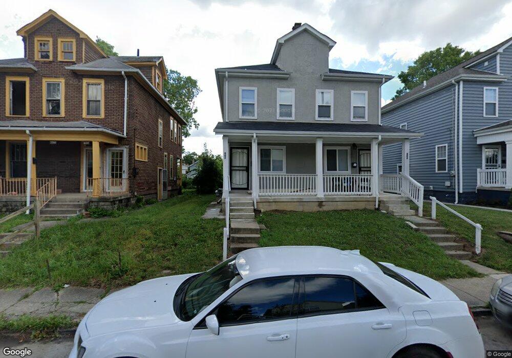
802 Kelton Ave Unit 802 804 Columbus, OH 43205
Driving Park NeighborhoodEstimated Value: $217,765 - $276,000
3
Beds
2
Baths
2,352
Sq Ft
$106/Sq Ft
Est. Value
About This Home
This home is located at 802 Kelton Ave Unit 802 804, Columbus, OH 43205 and is currently estimated at $250,441, approximately $106 per square foot. 802 Kelton Ave Unit 802 804 is a home located in Franklin County with nearby schools including Fairwood Alternative Elementary School, South High School, and Capital Collegiate Preparatory Academy.
Ownership History
Date
Name
Owned For
Owner Type
Purchase Details
Closed on
Feb 28, 2018
Sold by
Stead Joel D and Stead Brian Erin A
Bought by
Findley Ohio Llc
Current Estimated Value
Purchase Details
Closed on
Aug 7, 2017
Sold by
Municipal Tax Investments Llc
Bought by
Stead Joel D and Stead Erin A Brian
Purchase Details
Closed on
Mar 30, 2017
Sold by
Hull Patricia A
Bought by
Municipal Tax Investments Llc
Purchase Details
Closed on
Oct 25, 1993
Bought by
Hull Ralph L
Purchase Details
Closed on
Jun 8, 1993
Purchase Details
Closed on
Nov 15, 1988
Create a Home Valuation Report for This Property
The Home Valuation Report is an in-depth analysis detailing your home's value as well as a comparison with similar homes in the area
Home Values in the Area
Average Home Value in this Area
Purchase History
| Date | Buyer | Sale Price | Title Company |
|---|---|---|---|
| Findley Ohio Llc | $28,000 | Northwest Advantage Title Ag | |
| Stead Joel D | $10,600 | Williamson Title Box | |
| Municipal Tax Investments Llc | -- | None Available | |
| Hull Ralph L | -- | -- | |
| -- | -- | -- | |
| -- | $35,200 | -- |
Source: Public Records
Tax History Compared to Growth
Tax History
| Year | Tax Paid | Tax Assessment Tax Assessment Total Assessment is a certain percentage of the fair market value that is determined by local assessors to be the total taxable value of land and additions on the property. | Land | Improvement |
|---|---|---|---|---|
| 2024 | $3,090 | $67,420 | $8,930 | $58,490 |
| 2023 | $3,051 | $67,410 | $8,925 | $58,485 |
| 2022 | $1,347 | $25,340 | $2,310 | $23,030 |
| 2021 | $1,349 | $25,340 | $2,310 | $23,030 |
| 2020 | $1,351 | $25,340 | $2,310 | $23,030 |
| 2019 | $668 | $10,750 | $1,860 | $8,890 |
| 2018 | $1,057 | $4,070 | $1,860 | $2,210 |
| 2017 | $0 | $4,070 | $1,860 | $2,210 |
| 2016 | $4,617 | $17,850 | $2,660 | $15,190 |
| 2015 | $1,862 | $17,850 | $2,660 | $15,190 |
| 2014 | $1,091 | $17,850 | $2,660 | $15,190 |
| 2013 | $1,009 | $20,965 | $3,115 | $17,850 |
Source: Public Records
Map
Nearby Homes
- 812 Kelton Ave Unit 814
- 831 Lilley Ave Unit 833
- 764-766 Kelton Ave
- 1390 E Livingston Ave
- 810 Miller Ave
- 778 Miller Ave
- 889 Kelton Ave
- 736-738 Lilley Ave
- 782 Berkeley Rd
- 730 Miller Ave
- 768 Berkeley Rd
- 1345 E Livingston Ave Unit 1347
- 693 Kelton Ave
- 910 Ellsworth Ave
- 961 Lilley Ave
- 959 Kelton Ave
- 780-782 Seymour Ave
- 688 Berkeley Rd
- 901 Miller Ave
- 928 Miller Ave
- 802 Kelton Ave Unit 804
- 798 Kelton Ave Unit 800
- 808 Kelton Ave
- 808 Kelton !Dnp! Ave
- 794 Kelton Ave Unit 794
- 790 Kelton Ave Unit 790
- 797 Kelton Ave
- 807 Lilley Ave
- 811 Lilley Ave
- 803 Lilley Ave
- 817 Lilley Ave
- 799 Lilley Ave
- 826 Kelton Ave Unit 830
- 793 Lilley Ave
- 776 Kelton Ave Unit 778
- 776-778 Kelton Ave
- 801 Kelton Ave Unit 803
- 778 Kelton Ave
- 807 Kelton Ave Unit 809
- 827 Lilley Ave Unit 829