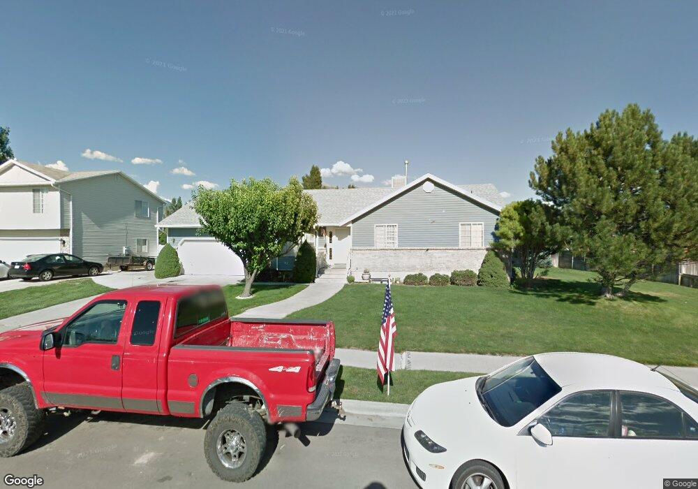
802 N 320 W American Fork, UT 84003
Estimated Value: $558,000 - $637,000
3
Beds
2
Baths
1,520
Sq Ft
$385/Sq Ft
Est. Value
About This Home
This home is located at 802 N 320 W, American Fork, UT 84003 and is currently estimated at $585,602, approximately $385 per square foot. 802 N 320 W is a home located in Utah County with nearby schools including Shelley Elementary School, American Fork Junior High School, and American Fork High School.
Ownership History
Date
Name
Owned For
Owner Type
Purchase Details
Closed on
Jun 8, 2024
Sold by
Reeve David A and Reeve Jeannie Lou
Bought by
Reeve Family Trust and Reeve
Current Estimated Value
Purchase Details
Closed on
Mar 22, 2019
Sold by
Cook Reeve Jeannie Lou and Cook Reeve Jeannie
Bought by
Reeve David A and Reeve Jeannie Lou
Purchase Details
Closed on
Mar 11, 2019
Sold by
Cook Mark Alan
Bought by
Reeve Jeannie Lou
Purchase Details
Closed on
Jan 23, 2019
Sold by
Reeve Jeannie Lou
Bought by
Reeve David A and Reeve Jeannie Lou
Purchase Details
Closed on
Sep 2, 2010
Sold by
Cook Jennings B
Bought by
Cook Jennings B and Cook Katie
Home Financials for this Owner
Home Financials are based on the most recent Mortgage that was taken out on this home.
Original Mortgage
$80,000
Interest Rate
4.51%
Mortgage Type
Credit Line Revolving
Create a Home Valuation Report for This Property
The Home Valuation Report is an in-depth analysis detailing your home's value as well as a comparison with similar homes in the area
Home Values in the Area
Average Home Value in this Area
Purchase History
| Date | Buyer | Sale Price | Title Company |
|---|---|---|---|
| Reeve Family Trust | -- | None Listed On Document | |
| Reeve David A | -- | Vanguard Title Ins Agcy Llc | |
| Reeve Jeannie Lou | -- | Vanguard Title Ins Agcy Llc | |
| Reeve David A | -- | Vnaguard Title Ins Agency Ll | |
| Reeve Jeannie Lou | -- | Vanguard Title Ins Agency Ll | |
| Cook Jennings B | -- | Affiliated First Title Comp | |
| Cook Jennings B | -- | Affiliated First Title Comp |
Source: Public Records
Mortgage History
| Date | Status | Borrower | Loan Amount |
|---|---|---|---|
| Previous Owner | Cook Jennings B | $80,000 |
Source: Public Records
Tax History Compared to Growth
Tax History
| Year | Tax Paid | Tax Assessment Tax Assessment Total Assessment is a certain percentage of the fair market value that is determined by local assessors to be the total taxable value of land and additions on the property. | Land | Improvement |
|---|---|---|---|---|
| 2025 | $2,466 | $299,915 | $226,600 | $318,700 |
| 2024 | $2,310 | $273,955 | $0 | $0 |
| 2023 | $262 | $272,140 | $0 | $0 |
| 2022 | $803 | $297,935 | $0 | $0 |
| 2021 | $556 | $398,800 | $162,600 | $236,200 |
| 2020 | $535 | $361,900 | $145,200 | $216,700 |
| 2019 | $1,898 | $345,800 | $134,300 | $211,500 |
| 2018 | $290 | $310,900 | $127,000 | $183,900 |
| 2017 | $351 | $163,020 | $0 | $0 |
| 2016 | $196 | $142,505 | $0 | $0 |
| 2015 | $328 | $139,260 | $0 | $0 |
| 2014 | $337 | $125,620 | $0 | $0 |
Source: Public Records
Map
Nearby Homes
- 914 N 400 W Unit A
- 3889 W 950 Cir N Unit 366
- 796 N 200 W
- 782 N 200 W
- 984 N 300 W
- 641 N 420 W
- 987 N 410 W
- 540 N 300 W
- 621 N 100 W
- 602 W 860 N
- 471 W 1040 N
- 344 W 1080 N
- 425 W 1120 N
- 10238 N 6530 W Unit 15
- 1051 N 390 E Unit 103
- 6079 W Whisper Ln Unit 404
- 1220 E 700 N
- 1039 N 390 E Unit 102
- 11338 N Annes Way Unit 8
- 6111 W Whisper Ln Unit 402