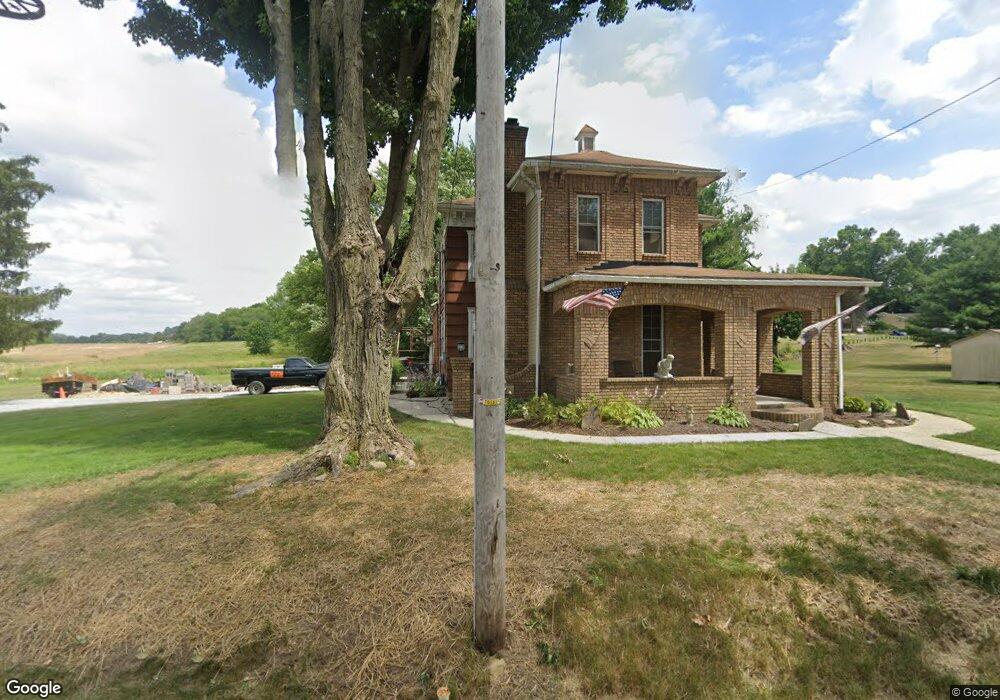
802 N Nickelplate St Louisville, OH 44641
Estimated Value: $152,000 - $256,000
3
Beds
2
Baths
1,754
Sq Ft
$119/Sq Ft
Est. Value
About This Home
This home is located at 802 N Nickelplate St, Louisville, OH 44641 and is currently estimated at $208,591, approximately $118 per square foot. 802 N Nickelplate St is a home located in Stark County with nearby schools including Louisville High School and St. Thomas Aquinas High School & Middle School.
Ownership History
Date
Name
Owned For
Owner Type
Purchase Details
Closed on
Jul 20, 2001
Sold by
Goffus Patricia J
Bought by
Ickes David F and Ickes Patricia A
Current Estimated Value
Home Financials for this Owner
Home Financials are based on the most recent Mortgage that was taken out on this home.
Original Mortgage
$77,950
Interest Rate
7.22%
Mortgage Type
Purchase Money Mortgage
Purchase Details
Closed on
Sep 27, 1999
Sold by
Goffus Patricia J
Bought by
Goffus Patricia J
Create a Home Valuation Report for This Property
The Home Valuation Report is an in-depth analysis detailing your home's value as well as a comparison with similar homes in the area
Home Values in the Area
Average Home Value in this Area
Purchase History
| Date | Buyer | Sale Price | Title Company |
|---|---|---|---|
| Ickes David F | $80,400 | -- | |
| Goffus Patricia J | -- | -- | |
| Goffus Patricia J | -- | -- |
Source: Public Records
Mortgage History
| Date | Status | Borrower | Loan Amount |
|---|---|---|---|
| Closed | Ickes David F | $77,950 |
Source: Public Records
Tax History Compared to Growth
Tax History
| Year | Tax Paid | Tax Assessment Tax Assessment Total Assessment is a certain percentage of the fair market value that is determined by local assessors to be the total taxable value of land and additions on the property. | Land | Improvement |
|---|---|---|---|---|
| 2025 | -- | $58,000 | $18,130 | $39,870 |
| 2024 | -- | $58,000 | $18,130 | $39,870 |
| 2023 | $1,629 | $37,880 | $13,690 | $24,190 |
| 2022 | $1,634 | $37,880 | $13,690 | $24,190 |
| 2021 | $1,638 | $37,880 | $13,690 | $24,190 |
| 2020 | $1,379 | $34,620 | $12,360 | $22,260 |
| 2019 | $1,385 | $23,240 | $3,290 | $19,950 |
| 2018 | $928 | $23,240 | $3,290 | $19,950 |
| 2017 | $796 | $19,220 | $2,630 | $16,590 |
| 2016 | $812 | $19,220 | $2,630 | $16,590 |
| 2015 | $815 | $19,220 | $2,630 | $16,590 |
| 2014 | $816 | $17,890 | $2,450 | $15,440 |
| 2013 | $411 | $17,890 | $2,450 | $15,440 |
Source: Public Records
Map
Nearby Homes
- 0 Michigan Blvd
- 1170 Winding Ridge Ave
- 910 Crosswyck Cir
- 325 Lincoln Ave
- 308 Superior St
- 2015 E Main St
- 520 S Silver St
- 641 S Nickelplate St
- 728 E Broad St
- 316 E Reno Dr
- 428 Honeycrisp Dr NE
- 3047 Mcintosh Dr NE
- 432 Honeycrisp Dr NE
- 2962 Mcintosh Dr NE
- 2963 Mcintosh Dr NE
- 430 Honeycrisp Dr NE
- 2957 Mcintosh Dr NE
- 1715 High St
- 203 Brookfield St
- 1812 E Broad St
- 716 N Nickelplate St
- 7070 N Nickel Plate St
- 626 N Nickelplate St
- 820 N Nickelplate St
- 624 N Nickelplate St
- 620 N Nickelplate St
- 615 Ohio Blvd
- 1143 Ohio Blvd
- 1141 Ohio Blvd
- 1221 Michigan Blvd
- 1211 Michigan Blvd
- 1231 Michigan Blvd
- 1205 Michigan Blvd
- 527 Ohio Blvd
- 527 Ohio Blvd
- 527 Ohio Blvd
- 527 Ohio Blvd
- 527 Ohio Blvd
- 0 Nickel Plate Ave NE Unit 3083086
- 0 Nickel Plate Ave NE Unit 3859208