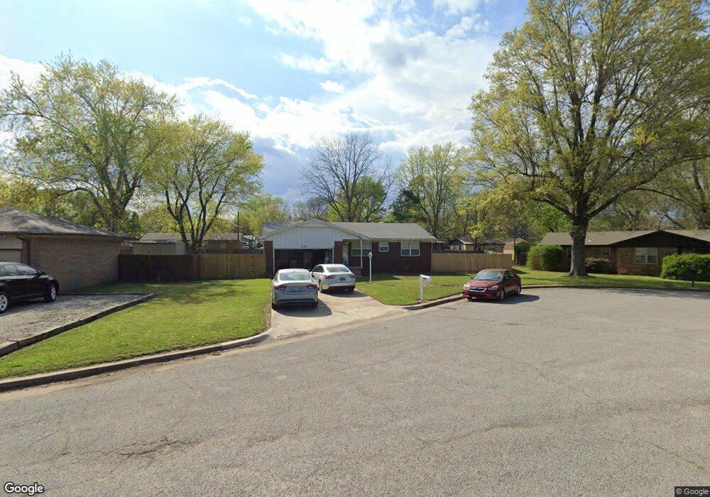
802 S Locust St Skiatook, OK 74070
Estimated Value: $173,000 - $188,000
3
Beds
2
Baths
1,268
Sq Ft
$141/Sq Ft
Est. Value
About This Home
This home is located at 802 S Locust St, Skiatook, OK 74070 and is currently estimated at $178,667, approximately $140 per square foot. 802 S Locust St is a home located in Osage County with nearby schools including Marrs Elementary School, Newman Middle School, and Skiatook High School.
Ownership History
Date
Name
Owned For
Owner Type
Purchase Details
Closed on
Apr 14, 2005
Sold by
Butler Jason M and Butler Stephanie D
Bought by
Butler Donald G and Butler Deetta J
Current Estimated Value
Purchase Details
Closed on
Apr 14, 2004
Sold by
Secretary Of Housing & Urban Dev
Bought by
Butler Jason M
Purchase Details
Closed on
Nov 20, 2003
Sold by
Killsnight Anthony
Bought by
Secretary Of Housing & Urban Dev
Purchase Details
Closed on
Sep 29, 2000
Sold by
Ledford Terry Diann
Bought by
Killsnight Anthony
Create a Home Valuation Report for This Property
The Home Valuation Report is an in-depth analysis detailing your home's value as well as a comparison with similar homes in the area
Home Values in the Area
Average Home Value in this Area
Purchase History
| Date | Buyer | Sale Price | Title Company |
|---|---|---|---|
| Butler Donald G | -- | -- | |
| Butler Jason M | -- | -- | |
| Secretary Of Housing & Urban Dev | -- | -- | |
| Killsnight Anthony | $71,000 | -- | |
| Ledford Terry Diann | -- | -- |
Source: Public Records
Tax History Compared to Growth
Tax History
| Year | Tax Paid | Tax Assessment Tax Assessment Total Assessment is a certain percentage of the fair market value that is determined by local assessors to be the total taxable value of land and additions on the property. | Land | Improvement |
|---|---|---|---|---|
| 2025 | $1,322 | $13,284 | $1,260 | $12,024 |
| 2024 | $1,263 | $12,651 | $1,200 | $11,451 |
| 2023 | $1,263 | $12,651 | $1,200 | $11,451 |
| 2022 | $1,253 | $12,651 | $1,200 | $11,451 |
| 2021 | $1,257 | $12,651 | $1,200 | $11,451 |
| 2020 | $1,247 | $12,474 | $1,200 | $11,274 |
| 2019 | $1,263 | $12,474 | $1,200 | $11,274 |
| 2018 | $1,258 | $12,474 | $1,200 | $11,274 |
| 2017 | $1,229 | $12,012 | $1,200 | $10,812 |
| 2016 | $1,175 | $11,441 | $1,200 | $10,241 |
| 2015 | $1,110 | $10,896 | $1,200 | $9,696 |
| 2014 | $1,056 | $10,904 | $1,200 | $9,704 |
| 2013 | $1,029 | $10,622 | $1,200 | $9,422 |
Source: Public Records
Map
Nearby Homes
- 724 S Haynie St
- 615 S Haynie St
- 534 S Osage St
- 1122 S Russell St
- 14 W Chestnut St
- 133 W Chestnut Place
- 1127 S Russell St
- 001 4th St
- 002 4th St
- 715 W 4th St
- 209 W 3rd St
- 116 W Dogwood St
- 0 E Maple St
- 305 E Elm St
- 1001 County Road 2265
- 312 E Elm St
- 106 S A St Unit 11
- 106 S A St Unit 3
- 411 Pine Ave
- 1128 S Quail Creek Rd
- 810 S Locust St
- 805 S John Zink St
- 718 S Locust St
- 801 S John Zink St
- 809 S John Zink St
- 717 S John Zink St
- 809 S Locust St
- 805 S Locust St
- 816 S Locust St
- 718 W Maple
- 813 S John Zink St
- 713 S John Zink St
- 714 W Maple
- 715 W Maple
- 715 W Maple
- 817 S John Zink St
- 824 S Locust St
- 800 S John Zink St
- 710 W Maple
- 825 S John Zink St