Estimated Value: $194,000 - $245,000
3
Beds
2
Baths
1,107
Sq Ft
$190/Sq Ft
Est. Value
About This Home
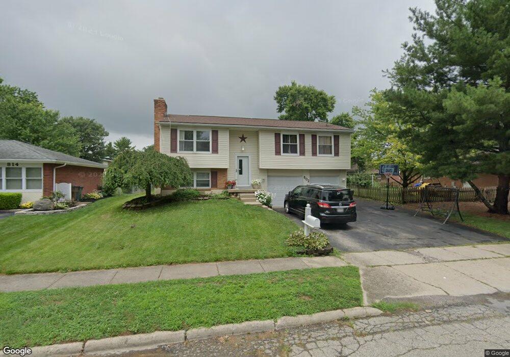
This home is located at 802 Tomahawk Trail, Xenia, OH 45385 and is currently estimated at $210,447, approximately $190 per square foot. 802 Tomahawk Trail is a home located in Greene County with nearby schools including Xenia High School, Summit Academy Community School for Alternative Learners - Xenia, and Legacy Christian Academy.
Ownership History
Date
Name
Owned For
Owner Type
Purchase Details
Closed on
Feb 5, 1999
Sold by
Fidler Stephen J and Fidler Jeanne I
Bought by
Dunn Robert W and Dunn Shannon M
Current Estimated Value
Home Financials for this Owner
Home Financials are based on the most recent Mortgage that was taken out on this home.
Original Mortgage
$100,950
Interest Rate
7.25%
Mortgage Type
VA
Create a Home Valuation Report for This Property
The Home Valuation Report is an in-depth analysis detailing your home's value as well as a comparison with similar homes in the area
Home Values in the Area
Average Home Value in this Area
Purchase History
| Date | Buyer | Sale Price | Title Company |
|---|---|---|---|
| Dunn Robert W | $99,000 | -- |
Source: Public Records
Mortgage History
| Date | Status | Borrower | Loan Amount |
|---|---|---|---|
| Closed | Dunn Robert W | $100,950 |
Source: Public Records
Tax History Compared to Growth
Tax History
| Year | Tax Paid | Tax Assessment Tax Assessment Total Assessment is a certain percentage of the fair market value that is determined by local assessors to be the total taxable value of land and additions on the property. | Land | Improvement |
|---|---|---|---|---|
| 2024 | $2,405 | $57,690 | $12,200 | $45,490 |
| 2023 | $2,405 | $57,690 | $12,200 | $45,490 |
| 2022 | $2,009 | $41,080 | $7,180 | $33,900 |
| 2021 | $2,036 | $41,080 | $7,180 | $33,900 |
| 2020 | $1,949 | $41,080 | $7,180 | $33,900 |
| 2019 | $1,721 | $34,150 | $6,740 | $27,410 |
| 2018 | $1,728 | $34,150 | $6,740 | $27,410 |
| 2017 | $1,566 | $34,150 | $6,740 | $27,410 |
| 2016 | $1,567 | $30,410 | $6,740 | $23,670 |
| 2015 | $1,571 | $30,410 | $6,740 | $23,670 |
| 2014 | $1,503 | $30,410 | $6,740 | $23,670 |
Source: Public Records
Map
Nearby Homes
- 1144 Rockwell Dr
- 1208 Bellbrook Ave
- 1272 Bellbrook Ave
- 1618 Navajo Dr
- 1342 Kylemore Dr
- 1568 Cheyenne Dr
- 1778 Arapaho Dr
- 1653 Seneca Dr
- 1283 June Dr
- 1233 June Dr
- 1391 June Dr
- 1223 June Dr
- 1769 Gayhart Dr
- 1829 Gayhart Dr
- 121 S Progress Dr
- 1866 Roxbury Dr
- 2758 Wyoming Dr
- 1908 Whitt St
- 305-325 Bellbrook Ave
- 219 Kansas Dr
- 814 Tomahawk Trail
- 638 Buckskin Trail
- 628 Buckskin Trail
- 828 Tomahawk Trail
- 664 Buckskin Trail
- 807 Tomahawk Trail
- 821 Tomahawk Trail
- 678 Buckskin Trail
- 833 Tomahawk Trail
- 641 Buckskin Trail
- 619 Buckskin Trail
- 854 Tomahawk Trail
- 655 Buckskin Trail
- 847 Tomahawk Trail
- 690 Buckskin Trail
- 667 Buckskin Trail
- 802 Moccasin Trail
- 866 Tomahawk Trail
- 816 Moccasin Trail
- 679 Buckskin Trail